 |
|
Why has the weather been so cool?
6/12/2008 For many of us in the Northwest, the record cool start to June seemed like the last straw after what felt like an exceptionally dismal spring. Let's check some facts though and then see if we can understand what happened The graph below shows daily temperatures for each day in the last 365 days, compared with the long-term average for each day (=climatology, the smooth curve); blue periods were cooler than "normal" and red periods warmer than normal. For most days since mid-September the temperature has been below average, and the last 360 days were on average 0.49°C (0.8°F) cooler than average. We can also trace a given day's actual temperatures sidewise to find the climatological date that matched it. So for instance, the temperature on the coldest recent day in June resembled a typical mid-April day, and the heat wave in April brought late-June temperatures. Of course, with the usual up and down swings of temperature, temperatures rarely equal climatology, but it's a little unusual to have a day so cold that it's as if it came from 6 weeks ago. 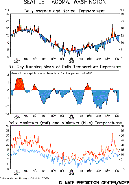
Source: Climate Prediction Center A warm spell in the second half of February, followed by remarkably cool weather in late March and early April, gave the impression of turning the clock back on spring. With all the lowland snow in March, wasn't it a lot like a typical January? The average temperature for March was 43.5°F, 1.65°F below average but still not quite January (average temperature 40.0°F), more like a February (42.8°F). And it was only the 18th coolest March; only one of the coolest 10, March 2002, has occurred since 1976. So although it was on the cool side, March was not even the coldest of the decade. For the statewide average it was only the 30th coolest, about 1.5°F cooler than average. What about April, which brought some unusually late snow to the Puget Sound lowlands? The mean temperature for April was 47°F, 2.3°F cooler than average, the 11th coolest April on record. And it was spiced with that one day that reached 80°F, just as May had a day that hit 90°F. Now, for eastern Washington, April was much more dramatic. In Spokane it was 4.7° cooler than average, the 4th coolest April on record. Statewide it was 4.6°F cooler than average, the 2nd coolest April ever (more than a degree warmer than April 1955). May's average temperature was unremarkable thanks to the warm spell in the middle of the month that offset a generally rather cool period. Statewide Average Temperatures
Source: National Climatic Data Center Statewide February was almost 2°F warmer than average, and was about 25% drier than average. March precipitation was almost exactly average, and April too was about 25% drier than average, the 28th driest April. For most of the state, precipitation in the last 6 months has been much below average: 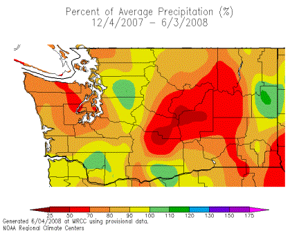 Only the green patches were above average. Most of eastern Washington had 80% or less of the average precipitation. Source: Western Regional Climate Center For the west as a whole, the temperature and precipitation of the past 6 months were below average almost everywhere (the Rockies were somewhat wetter than average). This contrasts with the usual La Nina pattern in which the southwest would be warmer and drier than average, and the Northwest cooler and wetter than average. 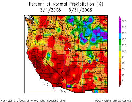
Source: High Plains Climate Center Finally, what caused all this cool weather? We can point to the proximal cause: the atmospheric flow. The two maps below show the anomalies (departures from normal) of the height of the 500 mb surface, roughly 3000 ft above the top of Mt Rainier. For most of the past 6 months (top panel) as well as for the beginning of June (bottom panel) a ridge over the North Pacific, marked by yellow and red, and a trough in the interior US, marked by blue and purple, have pushed cold air from Alaska straight toward the Northwest. 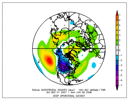 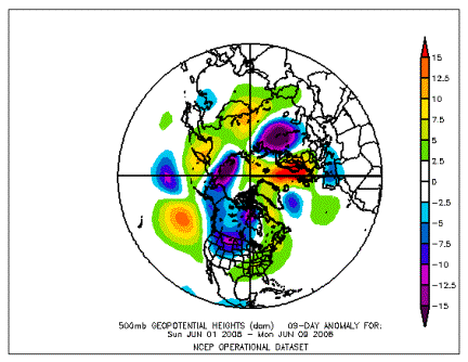
Source: Earth System Research Laboratory But this is what we might call the "proximal" cause, which leads immediately to the question, OK, what made the atmosphere do that? Sometimes we can point to conditions in the tropics that change the likelihood that the flow will be from one direction or another. A "La Ni�a" pattern of tropical ocean temperatures, like the current one that began last summer, often leads to cooler and wetter conditions here. In the soggy winter of 1998-99, for example, La Ni�a helped Mt. Baker break a world record for snowfall (a mind-boggling 100 feet). But wait, the past winter and spring were quite a bit drier than average. Furthermore, while the southwest was considerably drier than average as is typical during a La Ni�a, it defied the La Ni�a pattern and has been cooler than average. So there are aspects of the pattern in the West that don't fit La Ni�a, although it may have contributed to the cool conditions as it probably did also in 1999.
|


 |