 |
|
January 2012 Snowfall
1/26/2012 The period of 14-19 January 2012 featured some heavy snowfall, and significant freezing rain in the lowlands of western Washington. An overview of the meteorology behind this event, snowfall totals, and some of the local impacts of the week of wintry weather are explored in this summary. A comparison is also made with the ice storm of December 1996. Tables 1, 2, and 3 show snowfall totals for locations in the south and central Puget Sound region. The tables are separated based on the meteorological networks that the information came from. Table 1 shows snowfall totals from ASOS instrumentation: the observations are taken from midnight-to-midnight, so the daily amounts listed are for the calendar day. Table 2 consists of cooperative observer (COOP) stations that had snow records for the time period: the time of these observations vary by volunteer observer and are listed in the Table. Table 3 lists observations taken by Community Collaborative Rain, Hail and Snow (CoCoRaHS) volunteers: these are 24-hr observations generally taken between 6 and 9 am on the date that the snow total is listed under. As evident by these tables, lowland locations in Thurston and Lewis County as well as Forks (in Clallam County) received the most snow from this event with some places measuring over 2 feet of snow in a 5-day period. The evolution of this weather event and potential long-term records that were broken are described below. 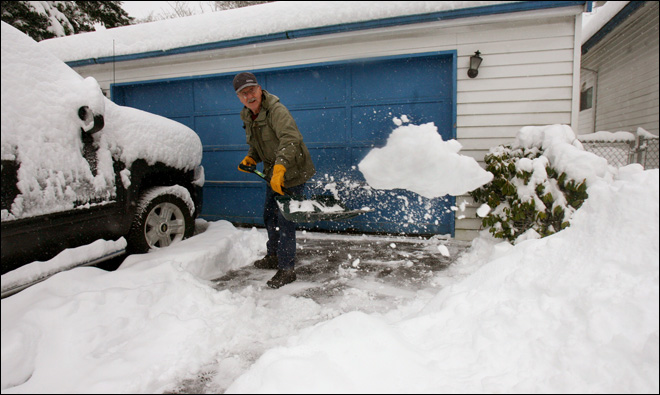 KOMO News photo of an Olympia resident clearing heavy snow from his driveway on 18 January 2012. Snow showers were hit and miss across western WA over the Martin Luther King Jr. holiday weekend (14-16 Jan), with some areas receiving substantial snowfall where a convergence zone developed. For most Puget Sound locations, the most intense of these snow showers were on the 15th (Tables 1, 2, and 3), with accumulation ranging between half an inch to 3 inches. The approach of a low pressure system to the south of WA and northerly winds helped draw cold air down from Canada on the 17th setting the stage for a more widespread snow event. The warm front associated with the low pressure spread precipitation into western WA on the 18th - overrunning the cold air at the surface and causing the precipitation to fall as snow. The heaviest lowland snow fell in the southern Puget Sound with 1-day totals of about a foot in Lewis and Thurston Counties (Table 3). Were the 1-day snowfall totals measured on the 18th record-breakers? Unfortunately, long snowfall records are hard to come by. Often, many years are missing within the record. With these caveats in mind, the 18 January snowfall at Olympia Airport (11.0") ranks as the 3rd most accumulation in a single day since 1948 (not a continuous record). Since the CoCoRaHS observations are relatively new to WA State (since 2008 with new observers added all the time), those records need to be compared to other nearby stations with longer records to get an estimate of whether record snowfall occurred. Those comparisons indicate that the 24-hr snowfall measured on the morning of 18 Jan rank as a record for several locations in Lewis County and one in Grays Harbor County. The Montesano 4.2 ESE (10.2"), Winlock 0.5 W (16.0"), Curtis 1.3 SW (14.2"), and Chehalis 1.4 SSE (14.0") CoCoRaHS stations were compared to the COOP records at Elma, Toledo, Doty, and Centralia, respectively, and all of the 18 Jan measurements are higher than any other 1-day snowfall measurement since records began. Despite the missing years of data, there is still good evidence that the 18 January snowfall was among the top 1-day snowfall amounts in that region. Records began in 1943, 1948, 1979, and 1902 at Elma, Toledo, Doty, and Centralia, respectively. Precipitation continued on 19 January, and with the cold air still in place in the central and northern Puget Sound, much of that precipitation fell as freezing rain or snow. The freezing rain was especially severe south of the Seattle metro area and is perhaps the more unusual aspect of this event. An estimated 250,000 customers lost power in King, Pierce, and Snohomish Counties (Seattle Times, 1/19/12) due to downed trees and power lines. The WA Governor proclaimed a winter storm emergency on the 19th to enable state agencies to use funds for assisting local communities and to ensure that milk was delivered statewide by waiving restrictions on dairy truck driver's work hours. The weather provided relief on the 20th for much of western WA when a deeper warm layer of air moved in changing precipitation to rain. Many WA residents remained without power for several days after the freezing rain ended, however. Freezing rain is a relatively rare weather hazard for western WA except for in the immediate vicinity of the Columbia River gorge. Over the last few decades, there has been one case that resembles the recent event and that is the ice and snow storm of 26 December 1996. The set-up for this storm featured cold but not frigid air of Canadian origin over WA, with a surface low pressure center approaching the mouth of the Columbia River from the west. The precipitation began as snow in the central Sound and freezing rain in the south Sound during the late night/early morning hours on the 26th before transitioning to mostly freezing rain from Seattle southward. Precipitation rates reached as high as 1" in 6 hours in Tacoma. As in the January 2012 case, the cold air was deep enough to yield all snow from Everett north. There are also striking similarities in the contrast between the afternoon conditions at Hoquiam, WA versus those at Astoria, OR. During both events, Hoquiam experienced winds from the east and northeast and temperatures in the low 30s, while a mere 60 miles south Astoria had high temperatures in the low 50s, heavy rain and southerly winds. As might be expected, the freezing rain had implications in terms of tree damage and downed power lines for both events. Airport operations at SEA were hampered, to put it mildly. All in all, the duration, intensity and area covered by the ice storm in December 1996 was greater for the region than any event going back to at least 1928. There are differences between the two cases in the weather that followed. The December 1996 ice and snow storm was followed by about a day and a half of dry, but cold weather before another storm moved in off the Pacific. This later storm was deeper and tracked farther to the north, and produced snowfalls of a foot or more from the evening of the 28th into the morning of the 29th before a changeover to rain of moderate to heavy intensity. While our recent event did not exactly end with a whimper, given the blustery southerly winds on its heels, it was nothing like the bang of the warm up in 1996. The combination of all that ice and snow followed immediately by rain at rates of typically 0.1 to 0.2" per hour caused all kinds of problems including collapses of marinas, carports and other structures, urban flooding and major landslides. The snow and ice storm of January 2012 was one of the highest impact weather events for western Washington in the last few years. It should be recognized that these impacts were minimized by the timely warnings from the National Weather Service and relatively effective and rapid responses by transportation departments and utilities. A small percentage of those that lost power had to wait a number of days for it to be restored. At least in part, that can be attributed to additional outages caused by strong southerly winds after it had warmed. We do not know if all the publicity last fall about a La Niña winter coming up had anything to do with the readiness, but it does seem that the region mostly "weathered" the storm. 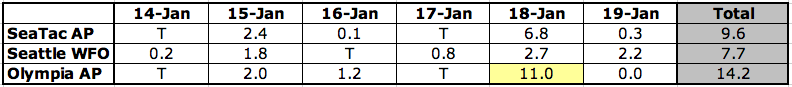
Table 1: Calendar day (midnight-to-midnight) snowfall totals (inches) for SeaTac Airport, the National Weather Service Forecasting Office in Seattle, and Olympia Airport. The highlighted value indicates near-record snowfall. Please click on the table to see the full-size image. 
Table 2: 24-hour snowfall totals (inches) for 5 stations in western WA along with the time that the observation was taken. Note that Cushman Powerhouse is near Shelton, Indian Summer Golf Course is near Olympia, and Mc Millin Rsvr is east of Lakewood. Please click on the table to see the full-size image. 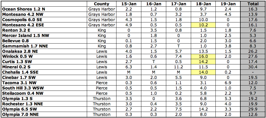
Table 3: 24-hour snowfall totals (inches) ending between 6 and 9 am on the day listed from CoCoRaHS observers. The highlighted values indicate near-record snowfall. Please click on the figure to see the full-size image.
|


 |