 |
|
A Review of Winter 2012-2013
4/22/2013 During September and October 2012, seasonal forecasts were indicating an increased likelihood of a drier and warmer winter than usual in Washington State due to the projected development of an El Niño in the tropical Pacific Ocean. The El Niño fizzled out during fall 2012, but was the winter true to the forecast anyway? This report summarizes the disappearing El Niño, and how Washington State's winter weather played out in terms of temperature and precipitation anomalies and snowpack. Figure 1 shows the sea surface temperature (SST) anomalies from January 2006 through March 2013 in Niño 3.4 region of the equatorial Pacific Ocean. A typical ENSO event looks more like the previous events shown in Fig. 1, where SST anomalies are of the same sign throughout the fall and winter, and peak in December or January. The last two winters, for example, included La Niña conditions. This past winter was classified as neutral and featured warm SST anomalies in the Niño 3.4 region through November and cool SST anomalies since December. Neither of these anomalies was strong enough to be classified as an El Niño or a La Niña. In early fall 2012, the models used to predict ENSO were indicating outcomes ranging from neutral to El Niño, with a consensus of a weak-moderate El Niño, resulting in a seasonal prediction of a winter on the warm and dry side for the Pacific Northwest. That was a flawed forecast, however, since the tropical Pacific cooled off relative to seasonal norms. 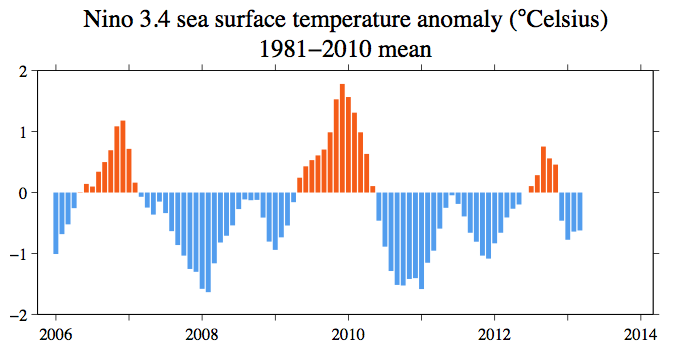
Figure 1: SST anomalies from January 2006 through March 2013 in the Niño 3.4 Region of the tropical Pacific (figure by Todd Mitchell - JISAO). Please click on the figure to see the full-size image. Neutral ENSO conditions do not provide as systematic of a signal in the temperature and precipitation anomalies for the PNW compared to either an El Niño or a La Niña event, so how did this year shape up? Figure 2 shows the mean October through March temperatures compared to the 1981-2010 normal for the entire U.S. Temperatures were near-normal for western WA, but between 1 and 1.5 degrees Fahrenheit warmer than normal for central eastern WA. The northeastern climate division was only 0.5-1 degrees Fahrenheit above normal for the winter, while the "Okanogan Big Bend" and the "Palouse Blue Mountains" division were near-normal. Winter precipitation was also near-normal for most of the state (Figure 3), with some exceptions. The Puget Sound lowlands and northeastern WA received precipitation between 2 and 5 inches above normal for the season. The coast was even wetter than normal with a 5-8" surplus of precipitation. With regards to the timing of the precipitation during last winter, the period of October through December was wetter than normal for most of the state while overall precipitation in January through March was below normal west of the Cascades and near-normal in eastern WA (Figure 4). The precipitation anomalies canceled each other out for most areas considering the winter as a whole. 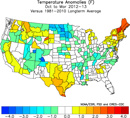
Figure 2: Oct-Mar 2012-2013 temperature anomalies (Fahrenheit) from the 1981-2010 normal (from ESRL). 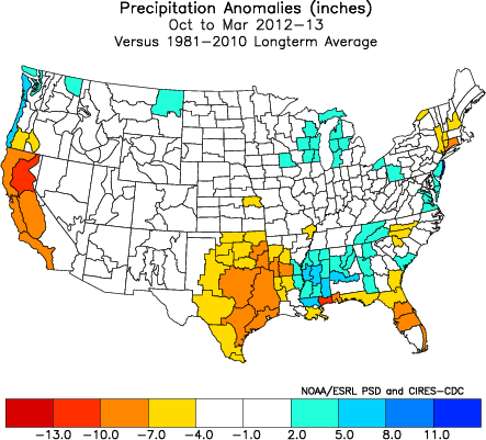
Figure 3: As in Fig. 2, but for precipitation (inches) (from ESRL). 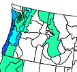 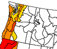  Figure 4: Oct-Dec 2012 precipitation anomalies (top) and Jan-Mar 2013 precipitation anomalies (bottom) (from ESRL). The average winter conditions provide one perspective on the past winter, but it is also worthwhile to consider the progression of the weather over the course of the season. The water year began extremely wet, with some stations recording October total precipitation amounts in the top ten wettest. Temperatures were near-normal to slightly above normal throughout the state; for November, average temperatures were warmer than normal statewide. Total November precipitation was variable throughout the state, and the snowpack lagged slightly behind normal in the central and southern Cascades as well as eastern WA where precipitation was below normal. That was not the case for December, however, as the snowpack built to above normal amounts in part due to heavy snowfalls in the middle of the month. Temperatures remained warmer than normal and precipitation was above normal statewide. As mentioned in the previous paragraph, January brought a shift in weather conditions, with colder than normal average temperatures and drier than normal total precipitation across the state. The drier than normal conditions persisted into February, but there was enough snowfall in the mountains, and a lack of warm high-elevation rains, to keep the snowpack in good shape. March was less consistent throughout the state, with temperatures and precipitation varying. Figure 5 shows the snow water equivalent for WA as of April 1, 2013; early April precipitation has enhanced the snowpack to no lower than 90% of normal at the time of this writing (April 18; Figure 6). The healthy snowpack has aided in a favorable water supply forecast. The National Weather Service Northwest River Forecast Center April through September water supply forecast (Figure 7) projects normal (90-110% of normal) to greater than normal (110-125% of normal) streamflow for most of the state. A few rivers, e.g., near Lake Chelan and Snake River near Granite Dam, are projected to have slightly below normal (75-90% of normal) streamflow through September. 
Figure 5: Snowpack (in terms of snow water equivalent) percent of normal for WA as of April 1, 2013 (from NRCS). Please click on the figure to see the full-size image. 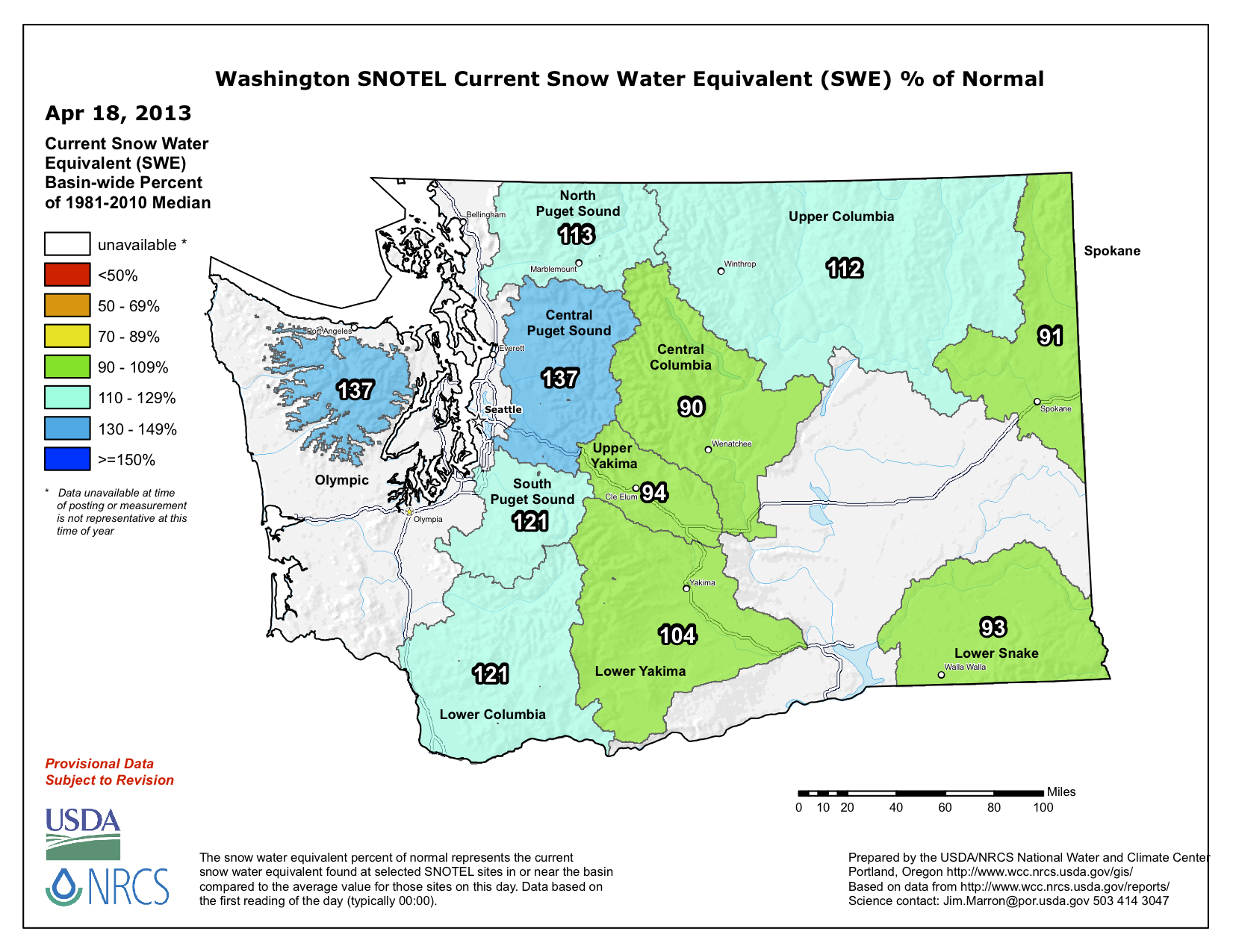
Figure 6: As in Figure 5, except as of April 18, 2013 (from NRCS). Please click on the figure to see the full-size image. 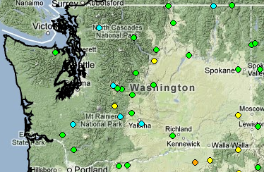  Figure 9: April through September 2013 water supply forecast for WA as of April 16, 2012 from the National Weather Service River Forecast Center. An interesting characteristic of winter 2012-2013 was the absence of large, damaging storm events. There were a number of weather disturbances accompanied by strong winds, as during most winters, but these storms had only modest impacts on the state in an overall sense. While the figures for the whole winter are not yet available, the property damages for October 2012 through January 2013 for WA have been estimated to be about $8.3 million (Storm Data, NCDC). The majority of this damage (about $5.6 million) was caused by the fall of snow-laden trees on the east slopes of the Cascades in mid-December. From the perspective of flooding in western WA, this past winter was quite benign. Table 1 lists the peak winter flow compared to average at six river gauges in western WA (winter flooding is not as common on eastern WA rivers as many of those are snowmelt-dominated). The peak flow this past winter was less than the average value at all of the sites, and much below the typical peak flow on the Queets River near Clearwater and the Snoqualmie River near Snoqualmie. For additional details on the sub-seasonal variations of this past winter, please see past editions of the OWSC monthly newsletter. 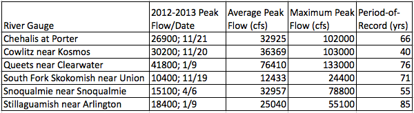
Table 1: The 2012-2013 winter peak streamflow (cfs) and date for 6 rivers gauges in western WA compared to the period-of-record (listed in years) average peak streamflow (cfs) and the period-of-record maximum peak streamflow (cfs). In summary, winter 2012-13 was wetter than normal throughout the Puget Sound, coastal areas, and northeastern WA and warmer than normal in most eastern WA locations. Otherwise, near-normal conditions existed elsewhere in the state over the winter as a whole. Despite the El Niño fizzling out, part of the seasonal forecast made in fall 2012 was correct: there were some parts of the state that ended up warmer than normal. On the other hand, the forecast for drier than normal conditions did not come into fruition. At the same time we did not experience any major flooding west of the Cascade Mountains, as illustrated by the relatively low peak winter flows itemized in Table 1. Additionally, our state snowpack is in good shape heading into summer. We will continue to monitor the state of ENSO and its predictions; by the middle of summer we should have a good idea of its potential to impact the seasonal anomalies for the upcoming fall and winter.
|


 |