 |
|
21 August Thunderstorms in Okanogan County
8/28/2014 Heavy rain occurred in Okanogan County on the evening of 21 August in the region of the Carlton Complex wildfire of earlier in the summer of 2014, leading to flash flooding and mudslides. Based on ground precipitation observations, spotter reports, and radar reflectivity data, storm totals were between about 0.20" to 1.15" in the region, with much of that rain falling in a period of about one hour. Certainly the damage that occurred was exacerbated by the storm happening to hit an area impacted by the recent fire. But how unusual was the storm itself? The Office of the Washington State Climatologist (OWSC) has carried out an analysis of this case based on consideration of historical data from nearby weather stations with multi-decadal records of daily rainfall, examination of imagery from the Spokane, WA NEXRAD radar (OTX) data, site-specific estimates of 2-year and 100-year return periods for 6-hour and 24-hour rainfall totals from the NOAA Atlas 2, and discussion with Ron Miller of the National Weather Service Forecast Office in Spokane, WA and Martin Walther of the WA State Department of Ecology Dam Safety Office. The daily precipitation totals in the vicinity of the thunderstorm are shown in Table 1, and range between 0.20 and 1.15". Examining the stations with the longest records, the Winthrop and Methow COOP weather stations, reveals that 1-day precipitation totals exceeding 1" are fairly common in the summer months of June through September, occurring on average every couple of years. This result is consistent with the return periods from the NOAA 2 Atlas for the location of the origin of the primary slides and floods, which indicate a 24-hour amount of 1.30" can be expected to be met or exceeded every 2 years (on average). The same atlas indicates that an amount of 0.77" in six hours has about a 2-year return period. So if the precipitation fell over 24-hours or even 6-hours, then we can estimate that an event of this magnitude would be between a 2 and 10-year event in the region. However, there is some strong evidence that the intensity of the thunderstorm was much greater, with reports of an inch of rain in 1 hour. 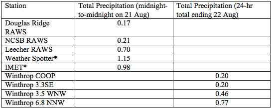
Table 1: Total daily precipitation measurements (inches) in the region. The RAWS sites measure precipitation from midnight-to-midnight so the observations are dated 21 August. The remaining sites are 24-hour precipitation measurements ending on the morning of 22 August, and mostly come from the CoCoRaHS network. The exception is Winthrop COOP which reports at 2 pm. *The observations from the weather spotter and incident-meteorologist were taken over an hour on 21 August, and are not daily totals. The heaviest 1-hour rainfall accumulation from the Spokane (OTX) radar shows an area of about 25 square miles with 1" from 6 to 7 pm local time (Figure 1). Ground observations consist of a Weather Spotter on Beavercreek Road southeast of Twisp with a confirmed report of 1.15", an incident-meteorologist measuring 0.98" a few miles away, and 0.48" at the Leecher RAWS site all in 1 hour. Much less data are available for characterizing the return periods of peak rainfall rates, but at any one spot in the North Cascades, a storm of the intensity of that of 21 August 2014 certainly qualifies as a rare event. Martin Walther (ECY, personal communication) used two separate procedures for calculating return intervals, including using an equation in the NOAA Atlas 2 to estimate 1-hour precipitation totals based on other precipitation intensities, and found that the area of the heaviest precipitation could be defined as a 100-year event. So while the total precipitation for the event was less than impressive when considered over a longer duration, the intensity of the event in a small area was remarkable. Yet, it is important to emphasize that characterizing the event as a 100-year storm may be a bit misleading in the sense that the region experiences occasional summer thunderstorms that have likely had comparable precipitation rates. There are storms north of Wenatchee on Figure 1, for example, that have higher 1-hour precipitation totals associated with them, and not nearly as much damage occurred there. An appropriate compromise may be to consider it a 2 to 10-year event from a total amount perspective, but more like a 100-year event in terms of precipitation intensity over a 1-hour period, for the particular area of about 25 square miles over which the heaviest rain occurred. To be clear, the area of heaviest precipitation did not exactly correspond to the region with the most damage. 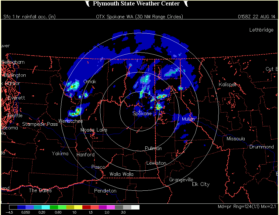
Figure 1: 1-hour rainfall accumulation from the Spokane (OTX) radar ending at 6:58 pm on 21 August 2014. Please click on the figure to see the full-size image. [Image from the Plymouth State Weather Center]. There are concerns that extreme precipitation events may become worse in association with climate change. The direct evidence here based on actual rainfall records is tentative, with some locations showing increases but other locations showing decreases. In an overall sense, there seems to be a slight tendency for an increase in the intensity of extreme precipitation events for the Pacific Northwest. But less is known about the seasonality of this signal. Some preliminary research carried out by the OWSC suggests that there may be a modest increase in the frequency of heavy rain events in eastern Washington state during the summer, but this result is highly tentative. There has been a secular increase in the humidity during the summer over WA during the last few decades, and this kind of change favors more frequent and stronger thunderstorms. Nevertheless, there is a great deal of year-to-year variability, i.e., noise, in a weak signal, and so whether there are robust trends in the observations remains an open question. The projections from climate models suggest that the environment will continue to moisten and hence become more favorable for extreme rainfall. On the other hand, these models, as a group, are indicating somewhat lower precipitation amounts during summer in the mean. It is possible that atmospheric circulation patterns will become less favorable for heavy rain, which would serve to negate the impacts of greater atmospheric humidity. In summary, the storm that hit Okanogan County during the late afternoon of 21 August 2014 was very unusual in terms of its peak intensity, but not unprecedented in its total precipitation amount. It is possible that these kinds of storms will become stronger or more frequent, but that is an issue that is far from settled.
|


 |