A Squall and Possible Downburst
in Northwest Oregon
December 13, 2001

a perspective by

Wolf Read

Image 1, Above. The storm gathers strength off of Washington and Oregon. By this time, 12:00 PST, strong winds and sweeping bands of moderate to heavy rain have already afflicted much of the western Pacific Northwest. Image courtesy of the University of Washington Archives.

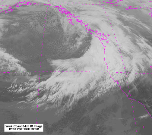
The storm of December 13, 2001 was one of the strongest of the 2001-02 season, producing heavy rain and strong winds across a wide area in the Pacific Northwest, though, overall, a couple of the storms from November 2001 probably had the edge in wind speeds. However, when compared the earlier storms of the season, the December 13th storm had an added feature--as the cold front dove across the Willamette Valley, undercutting a warm, moist sector of air that had been pulled in out of the south by the cyclonic flow, 
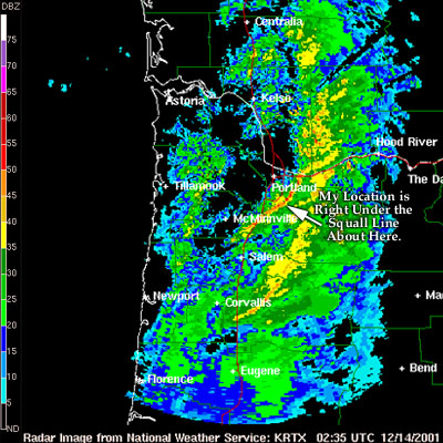
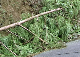
a narrow, but intense, squall line built up and tore through the SE Portland Metro area. The tempest hit my neighborhood dead on, producing the highest winds and heaviest short-duration rains of the storm season. My journal entries, and some images, will show the rest, but before going into the details, a few things should be noted at first.

The squall was spawned by a developing 980 mb cyclone that moved in out of the west. The cyclone's center crossed the Northern Olympic Peninsula and carried a very moist front inland. Heavy rain was reported at most interior stations at various times during the storm. Gusty south winds developed along the front, and in some valley locations approached 50 mph. This storm followed a track that could have resulted in even higher winds than those that were recorded. Interior gradients peaked at about +6.2 mb (+0.18") for EUG-PDX at 19:00 on the 13th and +10.6 mb (+0.31") for PDX-SEA at 01:00 on the 14th. On the coast, the peak ACV-AST gradient reached +23.9 mb (+0.69") at 13:00 on the 13th and the max OTH-UIL was +21.4 mb (+0.63") also at 13:00. These are strong gradients, but not quite at the level typically observed during big windstorms. Another 2 to 4 mb higher for the interior, and 50 to 60 mph gusts probably would have been more common.

The Aurora, OR, (UAO) airport was the closest official observation station to my location at the time of the storm (I have since moved), which is why it appears fairly often in the account below. Compared to my former site, UAO is more centrally located in the Willamette Valley. My location was closer to the foothills among rougher topography, which appeared to make for more turbulent (and weaker) winds in the region around my home.

To get an idea of the magnitude of the precipitation during the actual squall, pay close attention to the entry at 15:07 HRS. The rain rate reported at that time, falling in prefrontal warm air advection conditions, is fairly heavy for low-elevation Pacific Northwest interior locations (0.15-0.30"/hr is going at a really good clip down in the valley). The rainfall rate during the squall was much, much higher.

December 13, 2001: Thursday

07:03 HRS: (Oregon City, OR) Cloudy, stratus. Warm: 49º F. South winds up to 15 mph recently. Rain gauge: 0.43"; 0.33" at 23:00 yesterday. Baro 29.92" S. 07:05 HRS.

08:25 HRS: Big storm already moving in. Possible gusts to 40 mph in the forecast. Rain moving in now. Lots of warm air advection with this one... 08:33 HRS.

12:15 HRS: Rain, south winds gusting 15-24 mph... Winds are already picking up solidly--AST [Astoria] up to 46 mph, UAO up to 33 mph, and Hoquiam up to 50 mph, avg 38 at 11:53. Pressures are plummeting, with Forks already at 29.25", HOQ 29.38", AST 29.43" and PDX [Portland] at 29.59". Gradient is at +17.1 OTH [North Bend]-UIL [Quillayute] and +28.0 ACV [Arcata]-UIL. Getting fairly major. Newport hvy rain, S40G53 at noon. Hvy rain all along the coast. Rain's really starting here. Warm. 12:22 HRS.

14:19 HRS: Rain to heavy rain. Wind gusts have been strong out of the south, but many seem to skip past the anemometer [which has the south vantage blocked by a stand of Douglas-fir]. Highest I've seen lately 18 mph, while UAO has hit 37 mph now. Temp 50.9º F. Barometer falling phenomenally fast at 29.42" now. UAO reported a 0.05" drop in 30 minutes! Rain at 1400 was 0.22" [my gauge]. Newport is gusting to 55 mph. 14:25 HRS.

Figure 1, Above. A complex mosaic of warnings and watches from the National Weather Service had accrued by 15:21, a condition that, on occasion, has been termed "tooty-fruity." Courtesy of the National Weather Service, Portland.

15:07 HRS: We got slammed by a 30 mph gust at 14:44--came in loud. Average 34-sec: 19.7 mph! Rippin! A smallish Doug branch landed right next to the rain gauge in that one--it's maybe 18" long, densely needled and twigged. The rain has been phenomenal: 0.40" at 15:00--0.18"/hr. Sheets--wind tossed. It is very soaked out there. 15:12 HRS.

18:35 HRS: It's dumping! The cold front must be approaching. I mean a cascade of water off of the porch, with gusts to 18 mph. Baro 29.35" steady at last check... Squall! Just had a gust to 29 mph. Still dumping. Radar shows red in band. 18:41 HRS.

Figure 2, Above. Doppler radar image captured right at the time of my journal entry, showing the well-defined band with 35-55 DBZ reflectivity: the squall line caught in its tracks. This was the last piece of information I acquired from the NWS website before the rain attacked my computer. Image courtesy of the National Weather Service, Portland, with additional text added by me.

19:17 HRS: Hosed! The house sprung many leaks. One came through the vent above the computer desk--apparently the product of carpenter ants which Gordon just found upstairs at the base of the west wall, a whole mess of ants, drones, new queens and so on. Getting back to the water--it poured right into the monitor. Fried the monitor in an instant, before I could even move. Zap, cut off from my weather! Right at the height of the storm, with winds roaring and the rain hammering down. So I was trying to deal with the flood--save the computer--while recording winds, which peaked at 32 mph, though it is possible that I missed a few gusts in the minute or so that the video camera wasn't recording when I thought it was; I shut off the surge protector below the computer desk, which the video camera was plugged into--apparently when the power is shut off, the camera shuts off, despite it having a battery! But I was vigilant--didn't really want to miss the peaks, so I think the 32 was the one. The rain was more amazing--it went spillover in the gauge for the first time. At 19:08, it totaled 1.38". By luck, I checked the gauge right after my shower at 18:33 HRS: 0.84" with moderate rain falling--that's 0.54" in about 30 minutes! It'll be awhile before that record is broken. There are a lot more details about this storm that I need to examine. And the pressure is still down: 29.31" about 20 mins ago. Things could still happen. And now, I need a new monitor! 19:31 HRS.

Image 2, above. At 17:00, the cyclone's center surges ashore on the Olympic Peninsula, pulling in a powerful front. Courtesy of the National Weather Service, Portland.

December 14, 2001: Friday

07:11 HRS: Aftermath. I still haven't collected critical weather data from online--can't get it from the Hubbard's computers for their Earthlink account is not working right. So I hope to go to the [ferret] Shelter after dropping Sil off at the bus stop [and get the data from their computer]. Then it'll be time to hit the field and measure. Lots of small branches and twigs on the driveway from this one. Big branches down on Lower South Walker. I went out after 22:00 [yesterday] and did some measuring. Two huge Douglas-fir branches landed on the road. One was 3.75" in diameter at the base and 21' long. The other was 3.5" diameter--didn't get length as branch was tangled with, and underneath, the other. These fell right at the bend. In the Abernethy Hollow area, a dead 3" dia, alder branch crashed down--main stem was 8' long. Lots of small twigs from a variety of trees, especially Doug and alder, all over the road, densely covering it in some places. Looks like the forest is trying to reclaim lost land. And this is all I could see under the headlights. It could be a very busy day. Also, the heavy rain sent a flood down the upper gravel driveway--carried mud and gravel all the way down to the big gray house section (more level) of driveway, past the lone alder in the puddle. 07:24 HRS.

Photo 1, Above. One of two large Douglas-fir, Pseudotsuga menzesii, branches that fell onto South Walker Road. The branches had been subsequently moved to the shoulder before this image was taken. The branch visible was over 20 feet long and had a base diameter of 3.75".

Peak Gusts for the Dec 13, 2001 Storm (some stations peaked on the 14th)
Data courtesy of the National Weather Service, Portland.
Wind speed converted from knots, R = Record

Location

Peak Gust

Gust Direction

Notes

Arcata, CA

43 mph

340º

 
Astoria, OR

49 mph

190º

1.77" rain on 13th: R
Aurora, OR

38 mph

190º

 
Eugene, OR

36 mph

180º

1.15" rain on 13th
Eureka, CA

39 mph

290º

2.01" rain on 13th: R
Everett, WA

39 mph

150º

 
Friday Harbor, WA

38 mph

230º

 
Hillsboro, OR

32 mph

180º

 
Hoquiam, WA

52 mph

290º

 
Kelso, WA

33 mph

300º

 
McMinnville, OR

35 mph

220º

 
Molalla, OR (HAM)

33 mph

MM

 
Navy Whidby, WA

59 mph

260º

 
North Bend, OR

58 mph

190º

 
Olympia, WA

40 mph

260º

2.12" rain on 13th: R
Portland, OR

38 mph

220º

0.76" rain on 13th [1]
Port Townsend, WA

38 mph

210º

 
Quillayute, WA

50 mph

290º

 
Renton, WA

35 mph

180º

 
Salem, OR

45 mph

170º

1.41" rain on 13th: R
Sea-Tac Airport, WA

40 mph

220º

1.63" rain on 13th: R
Troutdale, OR

38 mph

200º

 
Vancouver, WA

40 mph

200º

[2]

[1] A public information statement issued by the NWS, Portland at 17:50 HRS on December 13, 2001 indicated a peak gust of 47 mph for the Portland Airport at 14:00 HRS. The 38 mph listed is what was reported on the Daily Summary report for December 13th, 2001. I don't know the reason for the discrepancy.

[2] Reading is for the airport. According to the same statement as in [1], a spotter in the Vancouver area reported a peak gust to 50 mph.

20:18 HRS: The survey was quite an eye-opener. In some places, like the Lower Hubbard Woods and North H. Woods, there was some extensive Douglas-fir branch damage. At least 6 primary branches broke from trees in the NHW, one of which was 1.5" in diameter and 14' long. None made the 2"+ cutoff to be included in the Major Damage tally, but I've noted their measurements. Also note that I studied the Doug-firs very closely and couldn't see any branches much bigger than the 1.5"-er that fell--it seem that the Dougs in the NHW are still too young to produce Maj Dam-like results. I may have to reconsider my cutoff at some point. Maybe the next study. 20:38 HRS.

Photo 2, Above. One of six large Douglas-fir, Pseudotsuga menzesii, branches that fell in the North Hubbard Woods during the December 13, 2001 storm. This one was the largest to fall in the woodlot, with a basal diameter of around 1.5".

22:20 HRS: The bigger damage was in the Lower H. Woods where no less than 3 separate instances of Major Damage happened to Douglas-firs--in one case a 3" diameter, 14' long branch fell on a 2.75" dia 19.5' L branch and broke it; then the two took out a dead 2.5" dia 14' long branch before all crashed into the ground in a big mess by the boulders at the north end. The Lower H. Woods had escaped Major Damage all the way up to this storm. And this one, it took some severe blows.

Photo 3, Above. One of three very large Douglas-fir, Pseudotsuga menzesii, branches that broke in the Lower Hubbard Woods during the squall's moderate gale. This one had a basal diameter of around 2.5", and was part of a 3-branch pileup triggered by an even larger limb that snapped from higher up the tree.

A large 5" dia and over 20' long (est) bigleaf maple branch also fell from a large tree near the upper end of Lower South Walker, not too far from the road's junction with S. Maple. The base of the branch had some rotting, or heartwood exposure at the point of breakage, so this one was waiting to go.

Rain: We had a total of 1.59" by the 07:00 reading, highest 7AM-7AM to date! Some showers followed, totaling 0.04" by 15:00. Cold, cold rain. Evidence of stream flooding was seen along Abernethy Creek where some fields had their grass laid flat, pointing downstream. Water surged across S. Maple Lane in a couple of places, leaving mud debris, and our local tributaries where flowing high all day.

The squall built as the cold front raced across the Willamette Valley, and hit us at high intensity. I saw lightning after it had passed. Most local stations did not get the wind or rain that we did. UAO was the closest, with 0.31" of rain in the hour of the squall. Most locales, including UAO, only saw gusts in the 20-25 mph range, SW-W. I didn't check wind direction during the squall [for my site], but it seems to have been out of the SW by the way the gusts slammed the SW-facing wall [also known as the "west" wall]. West winds followed. Radar also showed the squall to be mainly a SE Metro Area event, moving into the Cascade Foothills. Yellow to orange pixels indicating heavy rain. Probably Gladstone to Molalla got the worst of the squall. 22:40 HRS.

December 13, 2001 Squall, Notes & Recollections:

During the height of the squall, arcing was witnessed from the substation on S. Maple Lane. The same person also had to dodge a number of large Douglas-fir branches on the road, and pass through the streams of water rushing across the blacktop.

I witnessed at least one longish brownout during the squall. No complete loss of power, though. The heaviest tree damage in the region seemed confined within 1-2 miles of my home, making suggesting that the region suffered the effects of a local downburst. The highest gust at my location, with an average of 21 mph and a peak at 32 mph, may not seem that fast compared to other stations. But it is significant relative to my site: those were the highest winds I witnessed on the Maximum Nor'Easter at my wind-sheltered location.

Also, the Maximum Nor'Easter anemometer samples at a rate of once every 3.4 seconds. Higher velocities could be easily contained between such widely spaced records. I later set up a Maximum Vigilant continuous-reading analog anemometer with the Nor'Easter as a repeater on the same sensor. During a Gorge outflow wind event in March of 2002 at Portland, a sudden gust of 42 mph on the Vigilant only registered 31 mph on the Nor'Easter--the latter device caught the blast on the upsurge, missing the peak velocity by only a fraction of a second. But it was enough to indicate a difference of 11 mph! Experimentation and correlation between the two gauges reveal that the peak instant readings of 29 to 32 mph indicated on the Nor'Easter during the December 13, 2001 squall suggest the possibility that brief gusts of 40 to 44 mph may have occurred. Considering the frequency of large branches broken from nearby Douglas-firs, gusts into the lower 40s seems a reasonable conclusion.

Last Modified: March 5, 2003
Page Created: January 12, 2002

You can reach Wolf via e-mail by clicking here.

| Back |