December 27, 2002 Minor Windstorm

compiled by

Wolf Read

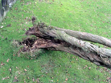
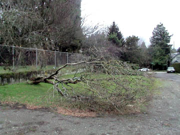
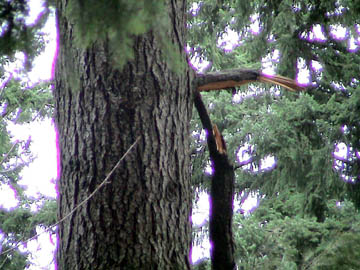
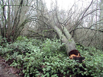
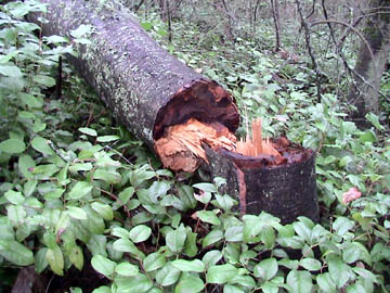
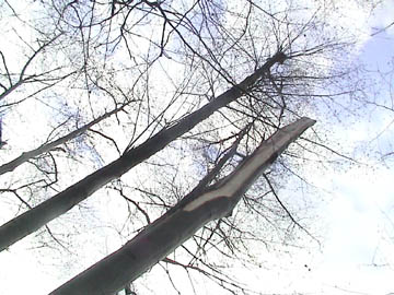
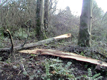
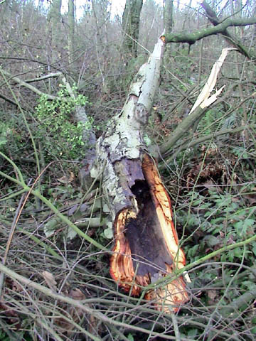
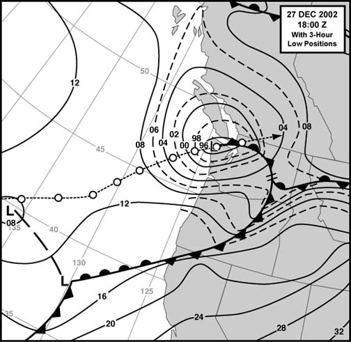
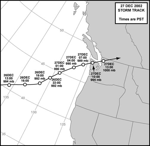
A fairly strong cyclone developed far off of Northern California on December 25 to 26, 2002, and then raced generally northeastward toward Washington's Olympic Peninsula. The track is detailed in Figure 1, above. With a minimum pressure of about 989 mb (29.21"), the low's center made landfall between 09:00 and 10:00 PST on December 27. Winds escalated south of the low's track as the storm swept inland, with south to southwest gusts reaching 50 to 65 mph at many locations on the coast, and 40 to 55 mph at many places in the interior.

According to National Weather Service storm spotter reports, damage to structures and trees occurred in coastal communities, with scattered power outages. From personal contacts in the region, power was also lost at isolated locations in the greater Seattle area, including Bellevue. I saw some trees and large branches down in the Portland Metro area, with brief brownouts occurring at my home during the gale. A wooden fence was smashed by a large limb on E. Burnside near 39th.

According to the Oregonian, an Olympia boy was electrocuted to death from a fallen powerline [1]. Outages were reported in Gresham, Cedar Hill and Banks. Two Gresham women were injured when a large branch broke from a tree and landed on them. Highways in the Coast Range, such as heavily-travelled 26, were blocked by fallen trees.

The Seattle Times reported that the storm cancelled power to about 260,000 customers in the greater Puget Sound Area [2]. Most outages were in East King County. Two people were injured--one by a pickup canopy that took to the air in the gale. A wind gust threw a tractor-trailer rig onto its side on the Tacoma Narrows Bridge, forcing closure of the important commuter link. The Lake Washington floating bridges remained open.

Here's what I noted about this storm in my journal:

December 26, 2002: Thursday

20:37 HRS: (Portland, OR) Rain is approaching heavy--this just escalated. Precip began at 14:20 during the Tabor walk, held steady for awhile, then faded by 17:03, after 0.06" had fallen with generally calm winds. Now the rain is thudding on the window, and gusts are reaching 10 mph out of the east. The baro is 29.81" falling, temp 41.3 F, digirain 6.7020" [for the month] (0.07" since 19:58 HRS). This is the leading precip of a deepening low that was at 42 N 135 W around 14:00, 994 mb, and is expected to make landfall on the Olympic Peninsula as a 985-990 system. This could very well be a windstorm, even for us. There's a chance the low could track further south, say over the mouth of the Columbia, which could really mean wind for us. So the weather folk are watching this one very closely. I'll be getting the latest update from the web soon. 20:39 HRS.

21:44 HRS: OK, according to the 03:00 Z (19:00 PST) surface analysis, the low was down to 992 mb and was located at 43 N 131 W still heading on a NE track. Tight gradients are starting to pack across NW CA at this time, and local barometers are starting to fall more quickly. Gradients like OTH-AST and AST-UIL are going negative right now (-0.9 mb and -1.5 respectively), the mark of a low still off the southern coast and beginning to influence Oregon conditions more strongly. ACV-OTH grad starting to pick up: +8.8 mb, up from +3.3 four hours ago. NWS, Portland, 20:05 forecast discussion says this low is right on track for that WA landfall--surface conditions are falling in line with the model runs. Looks like some fun weather for tomorrow morning! Currently: 29.74" falling rapidly, 39.3 F (and falling, too!), rain w/stratus, 6.8320", and E winds up to 13 mph at times, doing 3-5 right now. 21:53 HRS.

December 27, 2002: Friday

03:30 HRS: We're getting brief heavy showers imbedded in light, misty precip now. Winds are SE gusting to 10 mph, with a 1-min velocity of 7 at 03:11. The temp is slowly rising at 43.1 F. A warm front is approaching as the low continues to race toward the Olympic Peninsula. Temps on the coast have risen into the mid-50s, and winds have escalated significantly. Gusts to 58 mph at Newport this hour, with steady SW 40. Light east winds at Astoria and 43-45 F switched to S at 24 mph gusting to 36 at 01:55, with a temp climb to 55. The 02:55 OBS shows a peak to 41 mph and 56. The warm front has also struck Eugene. At 22:54, the temp was 42 F and it was calm. Winds shot in out of the S at 23:54 and the temp rose to 48; now, at 02:54, S winds are 23 mph gusting to 30 and the temp is 52 (High 53 01:53). The warm front hit Salem around 01:56, and now they're gusting to 30 mph with 50 F. Hasn't reached Aurora yet--calm and 43 F there at 02:53. The low center is nearing the coast--baro at 29.37" at the Columbia River Bar Buoy 46029. Still falling. South winds 34 mph gusting to 40, max 45 at 02:00.

Hmmm... After reaching 29.56" about 15 mins ago, the baro is now reading 29.58" here. Back to 29.57" again (03:45). I think the warm front is nearing. Digirain is at 7.1384" now (03:49).

I'm printing out the latest surface charts... 09:00 Z (01:00 PST) North America shows the low at 45 N 128.5 W now, with a 990 mb (29.23") center. I'd expect the Columbia River buoy to get close to this minimum pressure as the system makes landfall. Strong gradient south of the low, shallower north. Interestingly, Olympia's METAR showed a north gust to 29 mph last hour. What's going on there? A spotter reported strong winds at Sedro Wooley, too.

Things are getting active, it seems. Baro is now at 29.54", digirain 7.1580" with light rain still falling, temp 43.1 F, winds SE at 5 mph. 03:58 HRS.

Photo 1, below: Base of a tree that fell over during the windstorm near 62nd and East Ankeny. Saturated soil from nearly 7.50" of rain during the previous 2.5 weeks, and a dead, rotting root system, probably contributed to this windfall.

04:18 HRS: The low is now decidedly going into Washington. At 04:00 OBS, Forks was at 29.34" F, and Astoria 29.41" F, so the AST-UIL gradient went positive in the last hour. What a contrast--south winds 35 mph gusting to 54 at Astoria now, with 56 F. At Hoquiam, E 23 mph gusting to 30 with a cold 37 F (and rain). Looks like the warm front went through Aurora, as they're at 47 F now with light south winds. That pressure change (at 03:45) may indeed have been the front. The cold air may be deeper here at the mouth of the [Columbia River] Gorge, and will take longer to erode. East winds still strong at Troutdale--20 mph gusting to 28. At the rate things are progressing, it looks like whatever wind event we get will be a mid-morning affair.

Temp 43.3 F, baro 29.53" F, digirain 7.2436" with a solid, saturating moderate rain still falling. Wind still around 5 mph. 04:27 HRS.

Photo 2, below: Wide view of the same tree shown in photo 1, above.

06:04 HRS: The south winds have begun, and with some force. The gust register is now at 27.7 mph and the Nor'Easter (NER) has hit 28 so far. Some of these gusts are rattling the screen doors. This wind picked up suddenly around 05:42, with gusts to 20 mph. The temp has warmed! Now 49.1 F--was 43.1 not long ago. We had one long sustained gust that did 26-26-27-25 [26 mph average for 10 seconds] on the NER, shoving the Vigilant (VNT) gust register ever higher!

High wind warnings are up all over Western Washington, and the Oregon Coast/Coast Range. Winds are expected to quickly escalate to 30 to 40 mph with gusts to 60 mph mid-morning. This includes Kelso, Toledo and north to Seattle and Bellingham. The Willamette Valley is in a 20 to 30 mph with gusts to 45 forecast, which is fairly standard for lows diving into the NW tip of the Olympic Peninsula.

Looking at the 06:00 official OBS: Astoria S 35G49 mph and 29.40" R, Newport SW 38G58 29.64" R... Aurora S 22G33 29.56" and...and Corvallis SW 30G46! Slamming the Mid Valley. Salem S 20G31 29.56" R. With that Corvallis reading, it looks like there's some potential here. In WA... Forks SE 8 but baro 29.26" F, and Hoquiam joined the southerly club with S 26G39 and 29.35" F. For here, current, 49.6 F, 29.54", 7.3792", and recent gusts to 27 mph. 06:19 HRS.

Photo 3, below: Typical branch broken by the windstorm. This plume, which had a 1.75" base diameter, fell at the top of Mt. Tabor. Limbs such as this rained down at many points in the park, with larger ones crashing into the children's play area and on the mountain's southwest side.

12:18 HRS: Wow, we had ourselves a genuine minor windstorm. My peak gust was a slamming 45 mph at 09:44. We've had many gusts of 30-36 mph, some sustained for long periods. The next highest gust was 39.5 mph at 08:47. 'Twas fun, though I'm quite worn out. Not much sleep!

The low, which deepened to 989 mb as it landed on WA, came ashore between Hoquiam and Quillayute, and then raced between Everett and Bellingham. Nothing but north winds at Bellingham, with gusts in the 50s out of the SE at Everett. The winds have just escalated in the past few hours in the Puget Lowlands. At 12:00 Sea-Tac had S winds at 31G48 mph, Renton S 28G49, and Boeing Field S18G40. Sea-Tac reported a peak of 52 mph that hour. Looks like gusts of 45-55 up there, while we had 35-45. Max EUG-PDX gradient was +5.8 mb, and the PDX-SEA has reached +10.3--fairly strong for the latter. Peak ACV-UIL was around +23.9 mb. A decent storm!

I'll summarize in more detail probably tomorrow. I'll be going up Tabor for a damage assessment around 14:00. Before closing, it should be mentioned that this system was a wet one, with 0.82" of rain by 07:00 [24-hr]. Rain rates were in the 0.11"-0.14"/hr range from 19:58 to 04:58 for many of those hours.12:35 HRS

Photo 4, below: A large Douglas-fir branch, with a 3" base diameter, landed next to a trail on the southwest side of Mt. Tabor.

20:05 HRS: A recent isolated shower kicked the digirain to 7.5532" by 19:33 HRS, dropping 0.13" in the hour leading up to the OBS. The rain total is starting to look interesting.

Damage on Mt. Tabor was generally limited to twigs and small branches. Quite a few Douglas-fir limbs fell, most of the larger ones "falling" in the range of 0.5" to 1.5" base diameter with lengths of 3 to 6 feet--not my 2" minimum diameter requirement for "major damage" category. Four Doug-fir branches rated major damage, two of which were just barely there with 2" diameters. One long branch still hung from its parent tree by a strand of bark--this one was at least 3" in diameter and about 25 feet long. There was another with a 3" diameter that struck ground and broke in two. I sense brittleness with much of the damage--many a Doug-fir branch, even the smaller ones, broke into 2 or 3 sections upon hitting the ground. Other major damage included a partially uprooted hawthorne above the lower reservoir, and an uprooted dead ornamental from a yard on East Ankeny between 61st and 62nd. Both these trees may have been victims of the heavy rain, which probably weakened the trees' footholds in the ground. It is interesting that this strongest-of-windstorms of the season so far didn't really cause significantly more damage than earlier, weaker, events. Seems like the earlier storms cleaned out much of the material waiting to go. 20:20 HRS.

Photo 5, below: This large branch, broken in the gale, still managed to cling to its parent tree.

Damage in Western Washington

December 31, 2002: Tuesday

07:15 HRS: Today I'm going to Renton, to see if any damage occurred in the [Puget Power] Powerlines.

10:42 HRS: (Scatter Creek Rest Area, south of Olympia, WA, on I-5) Windstorm damage up the I-5 corridor was almost nil in Vancouver (I-205), with scattered broken limbs--willow, alder and Douglas-fir--up to about Kelso. Some dead trees from recent drought [and related fires on the freeway's shoulder] broke along the first 50 miles, and beyond. Near Exit 59, a large two-posted highway sign was shoved over (wooden posts), and from that point, a few live trees were broken, usually alder along the narrow greenways. Maybe two or three total from MP 59 to here. On big Doug-fir fell to the right side of the road just a few miles south of here (MP 88 roughly). This is the largest tree that I've seen down, maybe 20-24" diameter, quite tall, green. Its base shattered. A small road sign was also down near Centralia at an on-ramp. Lots of small branches broken here at the rest stop, mastly Doug-fir. 10:56 HRS.

Photo 6, below: This large birch broke in a Renton, WA, woodlot located in the eastern highlands.

12:13 HRS: (Phillip Arnold Park, Renton, WA) On I-5, there was heavy branch damage in the Fort Lewis area, then surprisingly little up to about Federal Way. A two-poster highway sign was blown down near MP 147. The single-poster "Entering Sea-Tac" sign was also blown down near MP 151. Both these signs had wooden posts. Wet soil conditions probably contributed to their toppling. I saw one broken alder on the hill just north of the Sea-Tac sign along I-5, and a Doug-fir that had dropped several large branches just ahead of the sign down near MP 147. Maybe a small alder down along the Renton exit from 167. Looks like some tree damage in the Powerlines. I'm going to check that out on foot. 12:20 HRS.

Photo 7, below: This is the same birch as in Photo 6. Close inspection of the base reveals discolored wood reaching into the heart right along the tree's braeak. This tree had been dead for some time before the windstorm struck, compromising the trunk's strength.

15:01 HRS: Back to the car from a fruitful trip through the Powerlines. The Northern Woodlot [which borders Phillip Arnold Park] lost two big birches. One snapped at the base, one uprooted. The snapped one was of ill health, with the heartwood breginning to rot. The uprooted tree also appeared recently dead, with brittle roots. Of course, the soil is also saturated. A small birch uprooted next to the bigger--their branches may have been entangled. A large very dead alder also broke near the Phillip Arnold tennis courts. Among the trees that line the rugged (south) road that goes to Phillip Arnold Park, a very large, but dead, birch uprooted and crashed across a mountain bike trail. Next to it, a smaller dead willow also crossed the trail on its way down. These are on the west side of the road, near the Northern Woodlot. On the east side nearby, an alder lost part of its top, and a large branch. The tree was alive, but not in the best of health. Not much more tree damage elsewhere along the road, and the gravel Puget Power road to the Southern Woodlot.

Photo 9, below: This fairly healthy alder, in a Renton highlands woodlot, lost its top in the gale.

The Southern Woodlot itself had tree damage. The most memorable was two alder trees that broke in close proximity to each other. One was fairly healthy, and it broke high up, maybe 20-25' off the ground. A massive "alder spear," a pointy wedge of wood from the base of the broken bough, maybe 8-10 feet long, sheared off and crashed to the ground with the top. The shattered tree blockaded the main mountain bike trail right near some serious jumps--new ones, in fact, made after my last visit. As I was photographing this windfall, two mountain bikers showed up and needed the tree out of the way of their jumps. We all got together and yanked the massive bough from the trail as best we could.

Photo 10, below: This is the same alder as in Photo 8. A large wedge of wood, a fairly common occurrence when alders break that I term an alder spear, sheared off the tree when the top snapped. Close examination of the middle of the spear shows discolored (darker brown) wood, again right in the break. This tree had previous injury, which appears to have compromised the tree's wind resistance.

The other alder also lost its top, a big chunk, but it was clearly diseased and ready to go. A dead, rotting, alder covered in ivy also went down. A dead birch lost its top, as did a live willow, at the west (lower) end of the woodlot. 15:33 HRS.

Photo 11, below: This large alder, near the tree depicted in Photos 9 and 10, was likewise beheaded by the windstorm. A clear hollow in the middle of the trunk, and degrading bark, reveal that this tree had passed its prime, and had become more wind-prone. It appears that a windstorm from many years ago--perhaps January 20, 1993 or December 12, 1995--broke this tree's original top off, exposing the heartwood to the elements. Over the years, the tree grew a substantial new top, seen to the lower left of the trunk, which added increasing weight to the tree. Simultaneously, the main trunk had weakened from heartwood rot. Finally, in appears conditions had reached a point where a marginal windstorm like December 27, 2002 could break the tree.

17:30 HRS: (Olympia, WA) On southbound I-5, again in the Sea-Tac area, a triple-post highway sign was down near MP 151. This one had metal posts. Looks like the bolts securing the sign to its foundation sheared off. Then, down at MP 143, another sign was down--triple-poster again, but wood. That area seemed to be the hardest hit on my route (MP 143-151). 17:33 HRS.

Photo 12, below: A broken, dead, scouler willow from the Renton Highlands. Human homes aren't the only ones that can suffer the consequences of a windfall. In this case, what appears to be a squirrel nest was thrown into some shrubs.

December 27, 2002: Meteorological Details

The surface map for 10:00 HRS PST is shown in Figure 2, below. These are the conditions at approximately the time of my peak gust of 45 mph (09:44), and when winds just began reaching gale force in the greater Seattle area. Note the closely-packed isobars reaching from central Oregon to northern Washington. The isobars are oriented almost west-east over the region, a nearly ideal situation for strong ageostrophic (jumping the gradient) winds in the south-to-north trending valleys, such as the Willamette and the Puget Lowlands. The pressure gradient was strong, but a number of storms on record have exceeded this storm's highest values (more on gradients below).

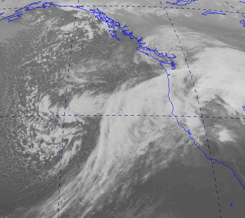
The 8-km resolution infrared satellite picture, Figure 3, below, shows the cloud conditions at the same time as the surface map above. The dry slot had become somwhat ill-defined by this time, which the storm's center in the gray area over the Olympic Peninsula. This cyclone didn't have a strongly developed bent-back occlusion, as evidenced by the warmer (darker) cloud tops north of the storm's center, when compared to say, the February 7, 2002 South Valley Windstorm and the December 16, 2002 storm. The bent-back was of moderate strength at best, though Bellingham did report brief heavy rain out of this feature from 11:08 to 11:10, then moderate rain up to 12:00, which totalled 0.15" from 11:53 to 12:00. Wind gusts out of 290 reached 18 mph at 11:53 HRS.

Source: Satellite photo is courtesy of the University of Washington Archives for weather data. Bellingham's rain data is from the National Weather Service, Seattle office, METAR reports.

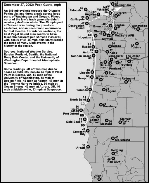
The peak gusts for this windstorm are shown in the map below, Figure 4. This cyclone lashed the immediate coastline of Oregon and Southwest Washington with 55 to 75 mph gusts, the Willamette Valley and Southwest Washington Interior with 30 to 45 mph gusts, the Eastern Puget Sound region with 45 to 60 mph gusts and Washington's North Interior, San Juans and Strait of Juan De Fuca with 20 to 35 mph gusts. The cyclone's track, which carried the center south of Bellingham, spared Washington's northern regions the strong winds seen in the Puget Sound. For interior sections, the Sound was in the ideal location for high winds with this storm, being south of the center, and very close, where gradients were at their steepest.

Source: Peak gusts are primarily from the National Weather Service, Eureka, Portland and Seattle offices, METAR reports, plus some from spotter reports, and National Data Buoy Center, realtime meteorological data.

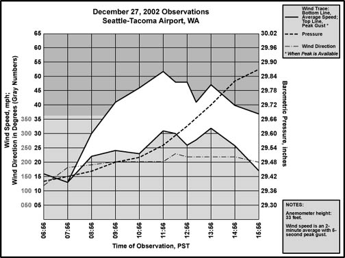
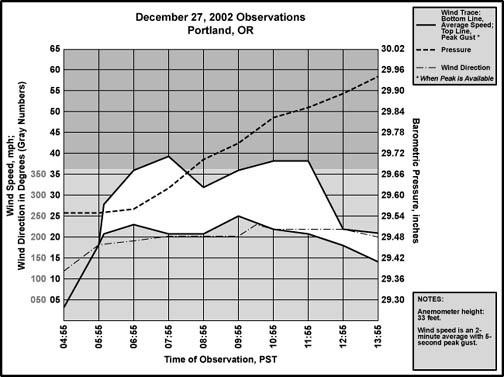
Examination of Some Interior Stations

Wind and pressure conditions are plotted for Sea-Tac and Portland in Figures 5 and 6, below. Conditions were quite similar between the two observation sites, indluding wind duration and direction. The differences are in lower pressures at Sea-Tac, with faster winds. And Seattle's barometer climbed at a faster rate as the low pulled away. These differences were probably due to Sea-Tac's closer proximity to the cyclone's center.

Source: Hourly data are from the National Weather Service, Portland and Seattle offices, METAR reports.

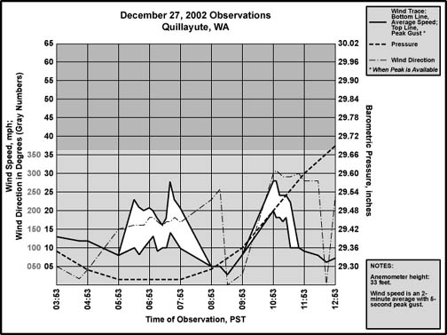
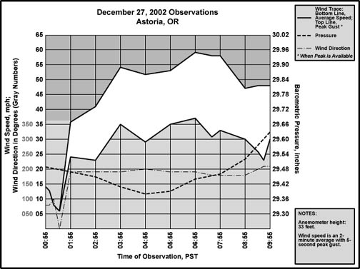
Examination of Some Coastal Stations

Wind and pressure conditions are plotted for Quillayute and Astoria in Figures 7 and 8, below. Conditions were dramatically different between the two observation sites. Astoria experienced a long period of southerly winds which quickly escalated to 25 to 35 mph with gusts of 50 to 60 as the barometer began to climb. Quillayute underwent a brief period of southeast to south winds which could barely manage 10 to 15 mph with gusts of 15 to 30 at the bottom of the pressure curve. These southerly winds died down as the pressure began to climb. Not shown on the meteograms, the temperature at Astoria climbed from 39 F at 23:29 HRS on the 26th to 56 F by 02:55 on the 27th during the maximum southerly winds, while at Quillayute it escalated from a low of 37 F at 23:53 HRS on the 26th to 49 F by 08:53 HRS on the 27th. Heavy rain accompanied the southerly winds at Quillayute, amounting to 0.19" between 06:53 and 07:53, strongly suggesting that the storm's leading occlusion was to blame for the southerly winds. Astoria, being further south, appears to have been south of the triple-point, and experienced the classic warm-front cold-front scenario outlined in the Norwegian model of cyclogenesis. In other words, Quillayute got a brief diluted taste of the warm air racing northward around the east side of the storm before the center made landfall around 10:00. Landfall, with the storm's center just south of Quillayute, is marked by the brief period of low wind between 08:53 and 09:53. The barometer started rising before this, suggesting that the low had already begun to weaken from terrain interference even before it made landfall. The 10:53 time period is marked by a sudden escalation of west-northwest winds to sustained values of 20 mph gusting to 28. A pressure surge of about 0.12" per hour for two consecutive hours accompanied this wind, and the temperature fell back to 39 F by 11:00. Quillayute was overrun by the cyclone's bent-back occlusion. Astoria's wind shifted to nearly westerly by 10:55, and this continued up to 12:55 with a lowering of temperature to 45 F by 11:55, all the mark of the storm's trailing cold front.

Source: Hourly data are from the National Weather Service, Portland and Seattle offices, METAR reports.

Wind Measurements at My Home in East Portland

A Maximum Vigilant anemometer with a Nor'Easter set as a repeater was used to take wind readings at my home. The sensor is about 26 feet above ground level, with a 250 foot site elevation. The methodology was simple: During a 4-minute observation window starting at the time of record, a set of 20 consecutive Nor'Easter readings were noted, usually during minute one to two, to calculate a single 1-minute average. The Nor'Easter samples every 3.4 seconds, so an average of 20 samples is actually a [(20-1)*3.4] 64.6-second value. Peak gusts on the Vigilant were also noted for the 4-minute period, as well as temperature, pressure, cloud and rain condtions. Between the main observation times, which were typically done each half hour, the Vigilant was monitored nearly continuously, with all gusts of 30 mph or more, and their times, noted. There was no attempt to calculate 1-minute averages between the main observations. Since many of the highest gusts occurred outside the regular obs, the highest 1-minute speeds were not masured. One-minute winds probably reached 22 to 25 mph during times of sustained 30-35 mph gusts, which sometimes lasted 5 to 10 seconds. Wind direction was determined by observing a string--tied to the anemometer mast at 23'--during a brisk wind period, and by the sway of nearby trees. In Table 1, below, the format is similar to the NWS x G y P z notation, with x being the 1-minute wind (NWS 2-minute), y being the peak instant gust in the 4-minute window (NWS peak 5-second gust in a 10-minute window) and z being the peak gust since the last observation. Winds tend to be particularly gusty at this location, especially when compared to the official sensors located among the open runways of airports. Mt. Tabor, who's peak is to the south-southeast, and who's forested western shoulder stretches out to the south, probably accounts for some of the turbulence, as do local trees, homes, powerlines and businesses.

December 27, 2002
Winds at the NW Foot of Mt. Tabor, in Portland, OR
Sensor Elevation 276' MSL, 26' AGL
Wind Speed in Miles Per Hour

Time, PST

Direction

1-Minute Wind
With Gust

Peak Instant Gust
For the Day

00:59

E

4 G 10

15.3

03:11

SE

7 G 10

15.4

05:42

S

13 G 20

20.5

05:48

S

13 G 24

24.3

05:58

S

14 G 27

27.5

06:28

S

15 G 28

28.4

06:55

S


30.0

07:00

S

18 G 30

30.7

07:08

S


31.5

07:30

S

11 G 20 P 30


07:38

S


32.0

07:57

S

16 G 27 P 29


08:02

S


36.0

08:27

S

16 G 32 P 35


08:47

S


39.5

09:00

SSW

10 G 31


09:29

SSW

13 G 29 P 35


09:42

SSW

G 37


09:44

SSW


45.0

09:57

SSW

14 G 28 P 35


10:29

SSW

11 G 27 P 35


10:58

SW

15 G 31 P 32


11:28

SW

13 G 35


11:58

SW

12 G 27 P 36


12:53

SW

10 G 18 P 25


14:00

SW

7 G 17


A Look at the Forecasts

The NWS forecast for the Portland area as early as 09:40 on December 26, 2002 was for winds of 20 to 30 mph with gusts to 45 by the morning of the 27th, almost 24 hours ahead of the actual event. I'd say this excellent job of forecasting verified quite nicely at my home. As did the forecasts for many areas of the Pacific Northwest for this storm.

What follows is a brief look at some of the National Weather Service forecast discussions about the December 27, 2002 storm. These were collected from the Portland and Seattle offices as the storm progressed. For the sake of brevity, material that wasn't directly related to the cyclone's development has been cut from these forecasts.

NORTHWEST OREGON AND SOUTHWEST WASHINGTON FORECAST DISCUSSION
NATIONAL WEATHER SERVICE PORTLAND OR
330 AM PST THU DEC 26 2002
 
.DISCUSSION...06Z GFE AND MESO ETA AGREE ON TIMING AND POSITION OF NEXTSYSTEM COMING IN THU NIGHT/FRI...HOWEVER, MESO ETA IS STILLSIGNIFICANTLY DEEPER THAN THE GFE. THE INTENSE STORM IS EXPECTED TOMOVE E OF 130 W OFF OF THE WA COAST AS IT MOVES NE BY 12Z FRI. WILLWAIT ON HIGH WIND WARNING AT THIS TIME DUE TO DIFFERENCE IN WINDSBETWEEN GFE AND ETA...WILL CONTINUE HIGH WIND WATCH ALONG THE COASTAND OVER COASTAL RANGE AND SW WA. HOPEFULLY 12Z MODELS WILL CONVERGEON ONE SCENARIO. LIKENS

The above prognostication shows awareness of the storm's threat, with an uncertainty about the exact storm track that would persist for some time. This is even more evident in the analysis from Seattle:

AREA FORECAST DISCUSSION
NATIONAL WEATHER SERVICE SEATTLE WA
315 AM PST THU DEC 26 2002
 
.SYNOPSIS...A DEEP LOW PRESSURE SYSTEM DEVELOPING IN THE PACIFIC WILL TRACK NORTHEAST TONIGHT...MOVING OVER THE SOUTHERN PART OF VANCOUVER ISLAND MIDDAY FRIDAY. THE LOW WILL TRACK INTO SOUTHERN BRITISH COLUMBIA FRIDAY AFTERNOON AND BRING THE POTENTIAL OF DAMAGING WINDS TO MUCH OF WESTERN WASHINGTON.
 
FRIDAY...NOGAPS AND CANADIAN MODELS RELATIVELY WEAK WITH THE INCOMING STORM WHEN COMPARED TO THE GFS AND ESP THE MESOETA. TRACK OF ALL MDLS RANGE FROM SRN VANC ISL TO CENTRAL WA COAST. NRN TRACKS WOULD BE IDEAL EVEN IF SFC PRES ISN'T AS GOOD AS WOULD WANT...HOWEVER SRN TRACK FORECAST BY CANADIAN REGIONAL AND SOMEWHAT BY THE NOGAPS RUN ARE WORRYSOME AS THIS WOULD CAUSE STRONGEST WINDS TO BE CONFINED SOUTH OF OUR AREA. NOW HAVE SOMEWHAT DISTURBNG TREND OF THE GFS IN WEAKENING THE LOW 5MB FROM 00Z RUN TO 06Z RUN WITH A SLIGHT SHIFT OT THE SE. WAS ALL SET TO JUMP ON A WARNING FOR THE COAST FOR FRIDAY TO GIVE A GOOD AMOUNT OF LEADTIME AND MATCHUP WITH SRN OFFICES...BUT THINK I'LL BACK AWAY AND LEAVE AS A WATCH AT THE MOMENT AND LET THE DAYSHIFT THROW UP THE WARNING LATER THIS MORNING AFTER A LOOK AT THE 12Z RUNS. STILL THINK WARNING WINDS A GOOD BET...JUST NOT QUITE 80% AT THIS TIME. WILL LEAVE THE WIND WATCH ALONE FOR THE REMAINDER OF THE FA AS WELL AS STILL UNSURE ON STRENGTH OF WINDS AND TIME OF OCCURANCE IS A BIT TOO FAR OUT THERE.

The tracks for the computer-model low were all over the Washington coast. In a general sense, the models were producing reasonable depictions of events on December 27, 2002, with a low moving onto the Washington coast. But the fine details of storm track can make a big difference for specific forecast regions. A low tracking over Astoria would mean much lower winds on the South Washington Coast compared to a low tracking across Quillayute. The southern track would tend to spare places like Long Beach and Hoquiam from damaging winds. The northern track would leave the two locations exposed to the low's southern side, the zone of highest risk for damaging winds during these cyclone events. Thus the reluctance to jump on a wind warning for the Washington Coast at this time. The Portland forecasters were in a better position, as the models were showing the storm moving north of Oregon, allowing for better confidence in issuing coastal warnings.

AREA FORECAST DISCUSSION
NATIONAL WEATHER SERVICE SEATTLE WA
900 AM PST THU DEC 26 2002
 
.SYNOPSIS...A DEEP LOW PRESSURE SYSTEM DEVELOPING IN THE PACIFIC WILL TRACK NORTHEAST TONIGHT...MOVING OVER THE SOUTHERN PART OF VANCOUVER ISLAND MIDDAY FRIDAY. THE LOW WILL BRING THE POTENTIAL OF DAMAGING WINDS TO MUCH OF WESTERN WASHINGTON.
 
.DISCUSSION...ALL EYES ARE ON A DEVELOPING 997 MB LOW LOCATED ABOUT 50 MILES EAST OF BUOY 46006...AT 41N/137W. WHILE MODELS APPEAR A MB OR TWO WEAK WITH THE CENTRAL PRESSURE AND ABOUT 30-40 KT WEAK WITH THE STRENGTH OF THE 300 MB JET...THE MESOETA AND GFS APPEAR RATHER WELL INITIALIZED. WATER VAPOR IMAGERY SHOWS GOOD DARKENING TAKING PLACE 41N/139W. WIND DIRECTION ALIASES FROM QUICKSCAT 12Z PASS APPEAR INCORRECTLY APPLIED PER BUOY OBS. BEST TRACK/STRENGTH WITH SOME DEVELOPMENT AS SEEN BY LOOP...MODEL...OBS WOULD TAKE CENTER OF LOW TO NEAR CAPE FLATTERY 18Z FRI AT 985 MB.
 
BUT THERE IS A GOOD DEAL OF UNCERTAINTY. WHILE I DISCOUNT THE VERY WEAK CANADIAN SOLUTIONS THAT TRACK THE SYSTEM INTO THE MOUTH OF THE COLUMBIA RIVER AT 995 MB...THE 12Z GFS SHOWS SECONDARY DEVELOPMENT AT THE BASE OF THE 500 MB TROF ALONG 140W AS ANOTHER LOW TRACKS INTO THE MOUTH OF THE COLUMBIA RIVER AROUND 998 MB SAT. THIS APPEARS TO BE STEALING ENERGY FROM THE LEAD SYSTEM OF INTEREST AND INHIBITS PRES RISES BEHIND THAT WEAKER SYSTEM AS IT TRACKS INTO BRITISH COLUMBIA.
 
GIVEN UNCERTAINTIES...WILL MAINTAIN THE HIGH WIND WATCH FOR ALL OF WWA FRI. WILL MAKE FUTURE DECISIONS ON WARNINGS BASED ON OFFSHORE BUOY OBS AND SATELLITE IMAGERY.
 
KEY WIND THREATS CONTINUE TO BE IN THE FOOTHILLS OF THE CASCADES LATE TONIGHT AN FRI MORNING...HENCE THE EXTENSION OF THE HIGH WIND WATCH TO LATE TONIGHT FOR THE FOOTHILL ZONES AND CASCADES...AS THERMAL PROFILES AND ELY PRES GRADIENTS LOOK SOMEWHAT FAVORABLE FOR MOUNTAINWAVES -- FOR THE NORTH INTERIOR AND COAST AS THE LOW PASSES TO THEWEST...AND ALL AREAS FRI AFTN AS THE LOW PASSES TO THE NORTH. ALBRECHT

The mid-morning Seattle discussion doesn't show much change in the uncertainty for the Washington forecasters, though a track into Southern Vancouver Island was favored, and the extreme southern track suggested by the Canadian model was thrown away.

NORTHWEST OREGON AND SOUTHWEST WASHINGTON FORECAST DISCUSSION
NATIONAL WEATHER SERVICE PORTLAND OR
230 PM PST THU DEC 26 2002
 
.SYNOPSIS...A SERIES OF PACIFIC STORMS WILL MOVE THROUGH THE FORECAST AREA INTO THE MIDDLE OF NEXT WEEK. A WARM FRONT WILL MOVE NORTH THROUGH THE FORECAST AREA TONIGHT...FOLLOWED BY A COLD FRONT FRIDAY...THE ASSOCIATED LOW PRESSURE AREA WITH THIS WEATHER SYSTEM WILL PRODUCE STRONG WINDS ALONG THE COAST AND COAST RANGES TONIGHT AND FRIDAY. A PARADE OF ADDITIONAL PACIFIC FRONTAL SYSTEMS WILL FOLLOW INTO NEXT WEEK.
 
.DISCUSSION... .SHORT TERM... PRECIP WILL INCREASE IN THE CASCADES AS SNOW LEVELS RISE SO WILL ISSUE A SNOW ADVISORY ABOVE THE 5000 FOOT LEVEL WITH LESSER AMOUNTS DOWN TO 4000 FEET. MODELS DISAGREE ON THE DEVELOPMENT OF THE SURFACE LOW ASSOCIATED WITH THE COLD FRONTAL SYSTEM THAT WILL MOVE INLAND FRIDAY. THE AVIATION LOOKS BEST ON TRACK AND STRENGTH WITH THE ETA TOO STRONG...AVIATION CATCHES THE IDEA THAT THE LOW WILL WEAKEN A BIT AS ANOTHER LOW DEVELOPS FARTHER SOUTH...THAT HAS BEEN THE PATTERN RECENTLY. WILL UPGRADE TO A HIGH WIND WARNING FOR THE COAST FOR TONIGHT AND FRIDAY COAST AND KEEP A HIGH WIND WATCH OUT FOR THE COASTAL MOUNTAINS...TIL THE STRENGTH OF THE LOW BECOMES MORE SURE. THERE WILL BE PROSPECTS FOR SNOW ADVISORY AMOUNTS AGAIN FOR THE CASCADES LATE FRI AFTERNOON/EVENING AS THE SNOW LEVELS DROP FOLLOWING THE COLD FRONT. WILLSON

During the afternoon of the 26th, the exact strength of the low was becoming a bigger issue than track, as a wave on the storm's frontal system threatened to sap some of the energy from the lead storm. Oregon, assuming a track into Southern Vancouver Island, would be on the periphery of the storm's strongest gradients. A deeper low could put Oregon under a stronger gradient situation, which could make the difference for high winds being limited just to the coast, or having broader coverage into the Coast Range. A really big storm moving on the Southern Vancouver Island track could even bring damaging wind to the Willamette Valley, but in the case of the December 27th low, this had been determined to be unlikely.

AREA FORECAST DISCUSSION
NATIONAL WEATHER SERVICE SEATTLE WA
215 PM PST THU DEC 26 2002
 
.SYNOPSIS...A DEEP LOW PRESSURE SYSTEM DEVELOPING OFF THE SOUTHERN OREGON COAST WILL TRACK NORTHEAST TONIGHT...MOVING TO NEAR CAPE FLATTERY MIDDAY FRIDAY. THE LOW WILL BRING THE POTENTIAL OF DAMAGING WINDS TO MUCH OF WESTERN WASHINGTON.
 
.DISCUSSION...ALL EYES CONTINUE TO BE ON A DEVELOPING 994 MB LOW LOCATED NEAR 41.5N/136.5W. MODELS CONTINUE TO SHOW CONSIDERABLE SPREAD ON THE TRACK AND STRENGTH OF THE LOW WITH THE MM5/MESOETA SOLUTIONS TAKING THE LOW INLAND NEAR DESTRUCTION ISLAND THEN NE TO S OF KBLI AND INTO CANADA...AND THE GFS MAINTAINING A TRACK INTO S CNTRL VRISL. THE SYSTEM CONTINUES TO ORGANIZE SLOWLY AS WHAT APPEARED TO BE DARKENING ON THE WATER VAPOR IMAGERY HAS RUN AHEAD OF THE SFC FTR...AND ANOTHER JET STREAK TO THE W APPEARS TO BE CATCHING UP WITH THE IT. OBS...SATELLITE IMAGERY AND MODEL SPREAD ALL POINT TO HANGING ONTO THE WATCH...AND LETTING THE SWING SHIFT MAKE A DECISION ON WARNINGS AFTER SEEING MORE OBS AND SATL IMGRY. ALBRECHT

In the Seattle Area Forecast Discussion, the MM5/MESOETA model struck gold, as thie actual path of the December 27th storm was very close to the one suggested during this model run. Of course, the forecasters didn't know that this MM5's track was close to the eventual real one, and the synopsis still suggests that the low would pass over Cape Flattery and into Southern Vancouver Island.

NORTHWEST OREGON AND SOUTHWEST WASHINGTON FORECAST DISCUSSION
NATIONAL WEATHER SERVICE PORTLAND OR
805 PM PST THU DEC 26 2002
 
.SYNOPSIS...A SERIES OF PACIFIC STORMS WILL MOVE THROUGH THE FORECAST AREA INTO THE MIDDLE OF NEXT WEEK. A WARM FRONT WILL MOVE NORTH THROUGH THE FORECAST AREA TONIGHT...FOLLOWED BY A COLD FRONT FRIDAY.
 
.DISCUSSION... .SHORT TERM...BUOY REPORTS AND S OREGON COAST METARS INDICATE MODELS APPEAR TO BE ON TRACK WITH THE LOW EXPECTED TO TRACK NE TO THE OLYMPIC PENINSULA BY FRI MORNING. CENTRAL PRES AT 46002 DOWN TO 995 MB BY 03Z WITH THE LOW CENTER TO THE W. WINDS AT K4S1 UP TO 41G61KTS S OF THE WARM FRONT THIS EVENING. OVERALL WINDS FORECAST APPEAR TO BE ON TRACK...AND WITH THE WARM FRONT MOVING UP OVERNIGHT THROUGH THE N AND CENTRAL OREGON CASCADES...WILL UPGRADE THAT AREA TO A HIGH WIND WARNING.

During the night, conditions at offshore buoys and coastal stations all pointed toward the cyclone moving into Washington's Olympic Peninsula as the models advertised, lending confidence to the wind forecasts. As supported by the Seattle forecast:

AREA FORECAST DISCUSSION
NATIONAL WEATHER SERVICE SEATTLE WA
940 PM PST THU DEC 26 2002
 
.SYNOPSIS...A DEEP LOW PRESSURE SYSTEM DEVELOPING OFF THE SOUTHERN OREGON COAST WILL TRACK NORTHEAST TONIGHT...MOVING TO NEAR CAPE FLATTERY MIDDAY FRIDAY. THE LOW WILL BRING THE POTENTIAL OF DAMAGING WINDS TO MUCH OF WESTERN WASHINGTON.
 
.DISCUSSION...HIGH WIND SCENARIO STILL ON TRACK THIS EVENING. WATER VAPOR SATELLITE IMAGERY THE LAST FEW HOURS SHOWS SUBSIDENCE BEHIND THE LOW INTENSIFYING AS EVIDENCED BY THE DARKENING OF THE DRY SLOT BEHIND THE LOW. GFS SLIGHTLY BETTER AS FAR AS INITIALIZATION GOES BUT AT 06Z DEEPER MESOETA WILL VERIFY BETTER. ONLY SMALL DIFFERENCES IN THE TRACK OF THE LOW WITH THE GFS TAKING THE LOW INLAND JUST A LITTLE FURTHER NORTH THAN THE MESOETA. EITHER WAY TRACK STILL KEEPS THE POSSIBILITY OF STRONG WINDS ACROSS WESTERN WASHINGTON TOMORROW. MODEL CROSS SECTIONS CONTINUE TO INDICATE GOOD FLOW REVERSAL EARLY FRIDAY MORNING IN THE FOOTHILLS. EAST TO WEST CROSS CASCADE GRADIENT INCREASING RAPIDLY TONIGHT. THIS TREND WILL CONTINUE WITH THE TRACK OF THE LOW. IN ADDITION THERE IS THE POSSIBILITY OF MOUNTAIN WAVE ACTIVITY. WILL UPGRADE TO HIGH WIND WARNING FOR THE FOOTHILLS WITH THE HIGH WINDS EXPECTED TO BEGIN AROUND 12Z FRIDAY MORNING.
 
NEXT CHANGE IN THE FORECAST IS FOR THE NORTHWEST INTERIOR. TRACK OF THE LOW WILL SWITCH THE WINDS TO NORTHEAST OVERNIGHT. DEW POINT TEMPERATURES ALREADY NEAR FREEZING AT 05Z WITH THE NORTHEAST WINDS BRINGING MORE COOL DRY AIR INTO THE AREA. ONSET OF PRECIPITATION WILL OVERRUN THIS SHALLOW LAYER OF COOL AIR FRIDAY MORNING. WILL GO FOR RAIN AND SNOW MIXED IN THE MORNING NORTH OF MOUNT VERNON. LAYER OF COOL AIR WILL BE SCOURED OUT QUICKLY ONCE THE WINDS TURN SOUTHEASTERLY. FOR THE REMAINDER OF THE AREA THE WATCH WILL REMAIN IN EFFECT.
 
COAST IS A TOUGH CALL TONIGHT. IF THE MESOETA TRACK IS CORRECT WOULD EXPECT STRONG WINDS ONLY FROM GRAYS HARBOR SOUTHWARD BUT IT IS STILL TOO EARLY TO CALL. WITH THE LOW DUE WEST OF THE SEATTLE METRO AREA FRIDAY MORNING...12Z-15Z TIMEFRAME...EXPECT LITTLE IN THE WAY OF WINDS OVER THE INTERIOR EARLY IN THE MORNING...LITERALLY THE CALM BEFORE THE STORM. MODELS CONTINUE TO SHOW RAPID PRESSURE RISES BEHIND THE LOW SO EXPECT THE WINDS TO PICK UP QUICKLY MIDDAY...BEYOND THE 12 HOUR TIME FRAME FOR A WARNING. PRESSURE GRADIENTS RELAX BEHIND THE LOW FRIDAY NIGHT AS THE NEXT MUCH WEAKER LOW DEVELOPS OFF THE SOUTHERN OREGON COAST. HAVE ISSUED LATE DISCUSSION TO GET AS MUCH DATA AS POSSIBLE. DARKENING ON THE WATER VAPOR PLUS BUOY 2 AT 05Z REPORTING SW WIND 35G49 KNOTS...AND IT IS NOT NEAR THE LOW CENTER...INCREASING CONFIDENCE IN HIGH WINDS FOR THE INTERIOR MIDDAY FRIDAY. felton

The timing of the high wind period for Seattle in the above discussion would pretty much verify. Seattle's strongest winds occurred right around noon, with light winds in the 04:00 to 07:00 PST (12Z-15Z) time frame when the cyclone was due west. So, 12-15 hours before the actual gale event, forecasters in Portland and Seattle had pretty much worked out the scenario and issued wind forecasts that would pretty much verify. Which led to:

HIGH WIND WARNING
ADMIRALTY INLET AREA-EASTERN STRAIT OF JUAN DE FUCA- EVERETT AND VICINITY-HOOD CANAL/KITSAP PENINSULA-NORTHWEST INTERIOR- OLYMPICS-SAN JUAN-SEATTLE METROPOLITAN AREA-SOUTHWEST INTERIOR- INCLUDING THE CITIES OF... TACOMA... SHELTON... SEQUIM... SEATTLE... PUYALLUP...PORT TOWNSEND... PORT ANGELES... OLYMPIA... OAK HARBOR... MOUNT VERNON... MONTESANO... MARYSVILLE... LYNDEN... KENT... FRIDAY HARBOR... FEDERAL WAY... EVERETT... EDMONDS... CLALLAM BAY... CHEHALIS... BREMERTON... BLAINE... BELLINGHAM... BELLEVUE AND ANACORTES
445 AM PST FRI DEC 27 2002
 
...HIGH WIND WARNING TODAY...
 
NORTHEAST WINDS WILL SWITCH TO SOUTHWEST MID MORNING OVER THE SOUTHWEST INTERIOR AND MIDDAY ACROSS THE STRAIT AND NORTHWEST INTERIOR. WIND SPEEDS WILL QUICKLY INCREASE TO 30 TO 40 MPH WITH GUSTS TO 60 MPH AFTER THE WIND SHIFT. THE STRONG WINDS WILL THEN BEGIN TO SUBSIDE FROM SOUTH TO NORTH. WINDS WILL CONTINUE TO QUICKLY DIMINISH THIS EVENING...BECOMING LIGHT OVERNIGHT.
 
THE WIND IS EXPECTED TO BE STRONGER THAN WHAT OCCURRED ON CHRISTMAS DAY IN THE INTERIOR AREAS. HOWEVER...THE DURATION WILL BE SHORTER THAN ON CHRISTMAS...WITH STRONG WINDS LASTING ONLY A FEW HOURS RATHER THAN MOST OF THE DAY. SOME TREE DAMAGE AND POWER OUTAGES ARE EXPECTED ACROSS THE WARNING AREA TODAY.

There were two regions covered by this high wind warning where the heavy winds did not occur. Washington's Southwest Interior, including Kelso, Chehalis and Olympia, experienced peak wind gusts in the 30 to 40 mph range. This despite the fact that nearby places such as Shelton, with a peak of 47 mph, and Tacoma, with a peak of 51 mph, had gusts more in line with the forecast. The lack of high winds in this region is hard to explain when gusts across the Willamette Valley were equally as high, if not higher, and just to the north, in the Puget Sound region, the high wind warning fully verified.

The other region missed by this cyclone's gale winds was Washington's Northwest Interior, including Bellingham, Friday Harbor, Port Townsend, Port Angeles and Sequim. These places appear to have had peak gusts in the 20 to 35 mph range, due to the fact that the low tracked just south the region. This exemplifies the difficulties in wind forecasting--a track difference of just 25 miles either north or south would have altered conditions enough to have changed the actual results, putting new areas under the gun, and sparing others.

Overall, despite the nitpicks, the forecast in the 30 hours leading up to the storm were clearly well done.

General Storm Data

Table 2, below, lists the barometric minimums for the December 27, 2002 storm at selected sites. Many Pacific Northwest windstorms have produced lower readings. The most depressed pressures during this storm were near the Washington shore, and included 29.22" at 07:00 at Buoy 46041 near Cape Elizabeth, and 29.24" at Destruction Island from 05:00 to 07:00.

Sources: National Weather Service, Eureka, Portland and Seattle offices, METAR reports, and the National Data Buoy Center, realitime meteorological data.

Location

Lowest
Pressure

Approx Time
of Lowest Pressure

California:    
Arcata

29.92"

01:00 HRS, 27th

Oregon:    
North Bend

29.62"

02:00 HRS, 27th

Astoria

29.38"

05:00 HRS, 27th

Medford

29.83"

01:00 HRS, 27th

Eugene

29.62"

03:00 HRS, 27th

Salem

29.54"

04:00 HRS, 27th

Portland

29.55"

04:00 HRS, 27th

Washington:    
Quillayute

29.26"

06:00 HRS, 27th

Olympia

29.41"

08:00 HRS, 27th

Seattle (Sea-Tac)

29.40"

07:00 HRS, 27th

Bellingham

29.39"

08:00 HRS, 27th

     
AVERAGE

29.54"


Table 3, below, lists the maximum gradients for some standard measures during the December 27, 2002 cyclone. Compared to big storms in the past, none of these readings are particularly extreme. The PDX-SEA measure of +10.7 mb approached some of the more extreme values in history, but still fell short of storms such as January 20, 1993 with an astounding +15.4 at 10:00, January 16-17, 1986 with +11.7 at 00:00 HRS, November 24, 1983 with +12.6 at 12:00 HRS, December 14, 1977 with +12.3 at 17:00 HRS, March 25-26, 1971 with +11.1 at 11:00 HRS, and November 3, 1958 with a strong +13.6 at 20:00 HRS.

The December 27, 2002 storm did, however, exceed the November 15, 1981 storm, which produced a peak PDX-SEA gradient of +9.7 at 15:00 HRS, and the major windstorm of November 13-14, 1981, which produced a peak of just +10.4 mb due to the storm center's distance offshore. Other storms that weren't quite at the level of the December 27, 2002 event include February 12-13, 1979 with a peak PDX-SEA gradient of +7.9 mb at 01:00 HRS, January 19-20, 1964 with +7.2 at 17:00 HRS, and even October 12, 1962 with +9.9 at 20:0--the latter probably for reasons similar to November 13-14, 1981.

Sources: National Weather Service, Eureka, Portland and Seattle offices, METAR reports, the National Data Buoy Center, realitime meteorological data, and the National Climatic Data Center, unedited surface observation forms (for historical storm pressure data).

Location

Max Gradient, mb

Approx Time
of Max Gradient

Coast:    
ACV-OTH

+11.4

02:00 HRS, 27th

OTH-AST

+13.4

09:00 HRS, 27th

AST-UIL

+9.2

10:00 HRS, 27th

ACV-AST

+18.3

05:00 HRS, 27th

OTH-UIL

+21.2

09:00 HRS, 27th

Interior:    
MFR-EUG

+7.6

04:00 HRS, 27th

EUG-PDX

+6.0

10:00 HRS, 27th

PDX-SEA

+10.7

11:00 HRS, 27th

SEA-BLI

+2.5

13:00 HRS, 27th

AST-DLS

-11.2

02:00 HRS, 27th

Another measure for storms that track across the Olympic Peninsula and/or South Vancouver Island is the longer PDX-BLI gradient. Table 4, below, ranks a number of memorable, and not-so-memorable, storms by this measure. The December 27, 2002 storm ranks a meager 14th place in this incomplete list of windstorms from 1934 to present. Some of this has to do with the fact that the storm's center tracked south of Bellingham, which probably had a reducing effect on the peak gradient. The PDX-BLI gradient might have reached +13 to +14 mb if the track had been more ideal, with the low center passing right over Bellingham. The +22.7 mb for the October 21, 1934 storm was taken from spotty pressure data, and could have been higher--the mark of one of the top most powerful storms of the 20th century.

Sources: National Weather Service, Eureka, Portland and Seattle offices, METAR reports, and the National Climatic Data Center, unedited surface observation forms (for historical storm pressure data).

PDX-BLI Gradients For Big Storms in History

Storm

Peak Grad, mb

Time/Day

Oct 21, 1934

+22.7

15:00 HRS, 21st

Dec 12, 1995

+22.0

21:00 HRS, 12th

Jan 20, 1993

+21.5

11:00 HRS, 20th

Nov 24, 1983

+17.8

14:00 HRS, 24th

Oct 12, 1962

+17.7

00:00 HRS, 13th

Nov 13-14, 1981

+17.0

11:00 HRS, 14th

Jan 16-17, 1986

+16.9

23:00 HRS, 16th

Mar 25-26, 1971

+15.1

12:00 HRS, 26th

Feb 12-13, 1979

+15.0

05:00 HRS, 13th

Jan 19-20, 1964

+14.3

17:00 HRS, 19th

Dec 14-15, 1977

+14.0

17:00 HRS, 15th

Oct 26-27, 1950

+13.8

04:00 HRS, 27th

Dec 22, 1955

+13.2

15:00 HRS, 22nd

Dec 27, 2002

+12.1

11:00 HRS, 27th

Nov 15, 1981

+12.1

17:00 HRS, 15th

Apr 13-14, 1957

+11.3

18:00 HRS, 14th

Dec 21, 1955

+10.2

20:00 HRS, 21st

Table 5, below, lists the peak wind and gust for eleven key stations in the Pacific Northwest, their direction, and their time of occurrence. "Peak Wind" is a 2-minute average, and "Peak Gust" is a 5-second average. By my own personal methodology, a wind event rates the term "windstorm" when the average peak gust of these eleven stations reaches 39.0 mph (gale force) or higher. The December 27, 2002 cyclone just barely made the cut, and is a minor windstorm. Moderate windstorms have an average of 45.0 to 54.9, and major windstorms are those that reach or exceed 55.0. Only a handful of storms have made the majors, including December 12, 1995, November 14, 1981 and October 12, 1962.

Bellingham was the big loser during the December 27, 2002 wind event. The highest gusts occurred with the pre-storm northeasterlies five hours before the cyclone made landfall. Sea-Tac stands out strongly among the interior stations for top winds, and the Oregon Coast clearly took the brunt of the storm. Interestingly, the averages for this event are almost exactly one-half of the average 49.7 mph 1-minute wind and 80.5 peak instant gust velocities achieved by the for the Columbus Day Storm. The Big Blow of 1962, on average, struck with about four times the force!

Note, however, that the newer 5-second gust adopted by the NWS muddies the kind of comparison that I describe here. See "Adjustments to Modern Storms."

Sources: National Weather Service, Eureka, Portland and Seattle offices, METAR reports.

Location

Peak
Wind
mph

Direction
Pk Wnd
degrees

Obs Time of
Peak Wind
PST

Peak
Gust
mph

Direction
Pk Gst
degrees

Obs Time of
Peak Gust
PST

California:            
Arcata

17

160

23:53 HRS, 26th

32

160

23:53 HRS, 26th

Oregon:            
North Bend

41

190

03:55 HRS, 27th

61

190

01:35 HRS, 27th

Astoria

37

190

06:55 HRS, 27th

59

190

06:55 HRS, 27th

Medford

20

150

17:43 HRS, 26th

30

160

22:53 HRS, 26th

Eugene

28

220

07:54 HRS, 27th

39

220

07:54 HRS, 27th

Salem

25

210

05:33 HRS, 27th

37

200

05:56 HRS, 27th

Portland

25

210

09:55 HRS, 27th

39

210

07:55 HRS, 27th

Washington:            
Quillayute

20

300

10:53 HRS, 27th

32

310

11:00 HRS, 27th

Olympia

25

240

12:22 HRS, 27th

40

190

11:21 HRS, 27th

Sea-Tac

32

220

13:56 HRS, 27th

52

200

11:56 HRS, 27th

Bellingham

14

030

04:53 HRS, 27th

22

030

04:53 HRS, 27th

             
AVERAGE

25.8

193


40.3

187


References

[1] Information for this sentence, and those following, is from "Winds roar over region, toppling trees," Oregonian, December 28, 2002, Metro/NW, pages E1 and E6.

[2] Information in this paragraph is from the Seattle Times article, "Windstorm whips region: 10-year-old killed; gusts litter area with debris," from the newspaper's online archives.

Last Modified: March 19, 2004
Page Created: December 28, 2002

You can reach Wolf via e-mail by clicking here.

| Back |