February 6, 1999: Saturday
0812 HRS: (Freshwater, CA) I'm back on the couch, with the storm going
full. Wind speeds are occasionally reaching 30 to 40 mph as far as I can
tell. Out of the south. Rain, heavy at times, is tapping on the greenhouse
window. It's been raining all night. The sky is periodically getting dark
and light--relative, of course, for it's a uniform gray, as heavier bands
roll through. Imagine my shock, after the sky began to lighten at sunrise,
when things became dark again.
I gathered info over the internet. Winds have been 40 to 55 mph on the
coast, with a tight gradient: at one point, 0500, Crescent City's barometer
was reading 29.57", while down in Arcata, it was 29.72" (low so
far 29.69"). Cloud tops are reaching 30,000 feet in some of the heavier
cells, and it looked like quite a broad field of precipitation was yet to
move through.
As the low deepened off of Oregon, pressures really fell to the north.
As low as 29.29" on the Washington coast. Some places in western Oregon
had pressure falls of 0.1" an hour. Bay Area locations experienced
1 millibar-an-hour for several hours until things leveled off at about 0600.
This rain's still coming down hard, with gusty winds. I recently heard
some birds singing. And earlier I saw some crows flying about, skiring along
the redwood grove behind our home. I wonder if they are senseing an end
to the storm, or were just hopeful--maybe the barometer's recent rise threw
them off.
It's getting dark again. Time to go watch the storm. 0834 HRS.
February 7, 1999: Sunday
1416 HRS: (Freshwater, CA) The weather has broken into a showery regieme
today, with another storm due tomorrow. Not before dumping 1.5 to 2.5 inches
of rain in the lowlands, and 3 to 7 in the highlands around here. The Bay
Area had 1 to 3 inches as moderate to heavy rain fell overnight and into
the morning. Winds peaked around 33 mph in Arcata and 52 mph at Crescent
City, with San Francisco airport seeing a gust to 43 mph.
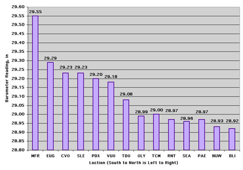
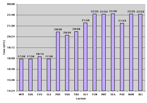
The low bombed out off the Washington coast, dropping the central pressure
to 978 mb before turning inland over the Olympic Peninsula. SeaTac Airport
saw 28.96" before the low cut to the north and east, bringing a short
bout of high winds up to 50 mph. Other barometric readings bottomed out
at 28.84" at Quillayute and about 28.92" at Bellingham. Port Townsend
saw 28.89". Peak gusts in eastern/central King County reported by spotters
were in the 58 to 64 mph range. Olympia saw 46 mph, Everett 52 mph and Portland,
OR, about 43 mph. Rain totals to north were lighter than here, in general.
1434 HRS.
1700 HRS: (Rest stop south of Laytonville on Hwy 101, CA) Impressions
of this drive so far (the mark of a recent heavy rainstorm):
A young, 2' diameter over 80' tall, redwood fell across 101 south, had
been sawed up and shoved onto the shoulder of the road. Freshly paved patches
of 101 north of Garberville, repairs from last year's El Nino rains,
cracked and sliding again. The Eel River muddy and turbulent, spilling over
onto the flood plains and swirling around the bases of alders, black cottonwoods,
and willows, even small redwoods in cases. White water cascading down from
rocky cliffs along the second biway section (counting north to south), pouring
down dozens of locations, spattering onto the narrow inside shoulder of
the road, beautiful waterfalls that weren't there before. Piles of rocks
in the same location, foreboding, bespeaking the danger of driving 101 in
the winter. Further south, in more open country, numerous mudslides beginning,
too many to county, some huge, over 25 meters wide, many small, little sections
of hill that liquified and poured down; many new rivulets in what were once
pristine hillsides. The biggest slides were the most foreboding, bulging
out, threatening to pop and spill their insides all over the road, some
with half-meter to meter high slump "cliffs", marking the fault
from which they began sliding, standing starkly from their tops: red brown
lines of clay-mud striking against the fresh green grass. Slides were most
evident in areas of recent highway construction, places without trees and
only a thin coast of new grass. A creek just north of Laytonville rushing
bankfull, surging over boulders and around alders; one Douglas-fir leaned
over the creek precariously, its roots having been exposed. A large mudslide
on a densely forested, very steep, hill, another red gash on verdant green.
The Eel River encroaching upon the "Reggae by the River" stage,
and getting frightfully near the lowest portions of 101.
And more and more--the mark of 3 to 7 inches of rain in less than 24
hours, with blustery winds. One more storm like that could shut down 101
with big mudslides and more flooding. 1730 HRS.
1838 HRS: (Ukiah, CA) A Douglas-fir was blown down just a half mile south
of the rest stop I wrote at last entry--the tree fell across south 101,
but was cut and carried out of the way. Also, the farm fields just north
of Willits were flooded--oaks standing among a shallow lake of muddy water.
The flooded fields went on for miles . . . mostly to the east of 101.
More wind and rain on the way tonight according to the radio KPIX 740
AM. A few stars are shining through high clouds: beautiful striated plains
of altocumulus looking like giant gray fileds ploughed overhead. The sun
melted away behind the clouds, looking like a headlight in the fog, long
before it set over the forested coastal mountains. Signs of an incoming
storm. The wind is calm. The air is cool. A brief respite before the next
event? 1845 HRS.
February 8, 2001: Monday
2140 HRS: (Lafayette, CA) A pine tree blew over Wildcat Canyon Road along
the eastern crest of the main ridge of the Berkeley Hills during this weekend's
storm. It completely crossed the road, and was sawed up & shoved out
of the way by the time of my commute this morning. A woman died in Marin
County when a 100-foot tree fell and crushed her car--the dange inherent
in these strong storms. Hopefully this house wont start sliding down the
hill and end up in the Happy Valley!
Finally, just off the west end of the San Rafael bridge, I saw a highway
construction sign: "TO HECK WITH THE RAIN." It was one of thse
big flashing trailer-born ones, though not flashing this time. The attitude
reflects the typical Bay Area opinion, but not mine! 2154 HRS. |