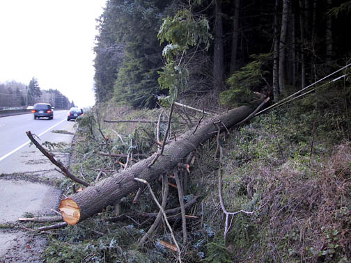
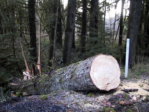
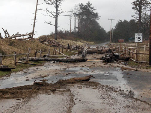
February 3 - 4, 2006 Windstorm

compiled by

Wolf Read

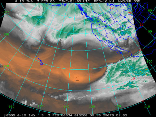
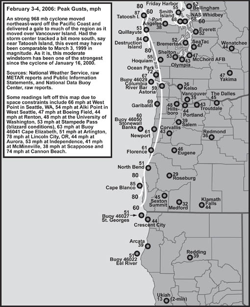
From February 3, 2006 into the afternoon of February 4th, at approximately 40 N latitude, a low deepened rapidly to about 968 mb (28.58") between 140 and 130 west longitude, and then moved northeast-ward fairly far off the Oregon and Washington coastline. This extratropical cyclone then hooked north just inside 130 W into the upper end of Vancouver Island as it degraded to 985 mb. In some ways, this system resembled the powerful March 3, 1999 cyclone, though the 2006 event tracked further west and hooked more sharply north, which likely contributed to a less forceful gale. Nevertheless, for some regions, including parts of Whidbey Island, the San Juans, the Northwest Interior of Washington, the north Oregon coast and Washington's entire Pacific coast, the 2006 event resulted in some fairly widespread damage.

Here are my journal notes:

February 2, 2006: Thursday

18:44 PST: (Mt. Vernon, WA) We’re close enough in time now that I feel compelled to note a possible windstorm for late Friday night into Saturday. Looks like a very deep, sub-970 mb, low will spin up far offshore and steam right toward the Olympic Peninsula and Vancouver Island. Some model runs have put the low at 963 mb, and, given that models like the GFS tend to under-represent the strength of these midlatitude cyclones, this one could go sub-960. A major system.

Right now, the National Weather Service has issued a high wind watch for most Western Washington Counties. According to this alert, for  the Seattle area, average winds could approach 40 mph with gusts approaching 60 mph by mid-Saturday morning when the filling low moves into British Columbia. Winds of this magnitude are possible across much of the Southwest Interior, the coast, and the Northwest Interior. Indeed, for the NW Interior, there could be a double round, with strong winds setting up as the cold front moves inland, and then surging again as the low passes inland to the north. The National Weather Service has suggested that this could be the biggest and most widespread wind event in years, perhaps since March 1999 or January 2000. Which means, it bears close watching. And such a significant weather event also means that all my weekend plans--including watching the Superbowl--could be dramatically changed!


The low is already forming NE of Hawaii, as this 16-km resolution WV satellite photo shows:

Figure 2: Water vapor satellite image showing the early stages in the development of the February 4, 2006 cyclone. The center has reached 150ºW along about 33ºN. Time is 17:00 PST on February 2, 2006.

The budding storm is that smallish-looking comma-shaped feature at about 35ºN/150ºW. It’s tapped into some tropical moisture, though not a lot, and has a good dry slot. The models suggest that the cyclone will deepen rapidly over the next 24 hours, so the wait to see what actually happens won’t be too long.

Figure 3: Satellite image of the deepening cyclone taken at 05:30 PST on February 3, 2006. The low shows strong development by this time.

February 3, 2006: Friday

 06:20 PST: (Mt. Vernon, WA) The cyclone is developing nicely and its center has now reached 140ºW. NWS Portland pointed out that the models track this low in a very similar fashion to 03 Mar 1999, which was a significant event. Official 5-second wind gusts in the Willamette Valley ranged from about 43 to 52 mph, which support the possibility of shorter bursts to about 60. A high wind watch has been posted for the Willamette Valley for about Marion County north. The watch has been elevated to a warning for coastal Oregon and Washington. Given fairly consistent computer model runs, confidence in how this event will unfold is pretty high among NWS officials both at Portland and Seattle.

This cyclone has a well-developed dry slot, with an enhancing leading cloud shield and a nicely-formed bent-back occlusion. Right now, this system looks like the real deal. Could be the strongest event of the winter season, in the least.

Although, I have to note that, based on a comparison of satellite photos, the above low seems to be tracking a bit further north than even 03 Mar 1999, at least right now. If the current system has a more easterly track, then this may not be a big factor. 06:29 PST.

Figure 4: The storm's center reached 135ºW by 10:00 PST.

10:38 PST: The low center appears to be at about 42ºN and 135ºW. Apparently central pressure is down to at least 980 mb (28.96”), probably even lower now. This system is moving at quite a good clip, as the two satellite photos [above], taken 5.5 hours apart, can attest to.

Warnings and watches for high wind are still up. The current MM5-GFS model runs suggest a peak EUG-OLM gradient of about 18 mb, which, when using a standard formula developed by the BPA, (EUG-OLM)*3.12, results in an expected peak gust of 56 knots (64 mph) at PDX. So, yeah, this is a storm to take seriously. 10:43 PST.

12:20 PST: The cyclone is still developing and moving along nicely. Buoy 46006, 600 nm west of Eureka, CA, has experienced some mean weather conditions. This includes a low pressure of 28.78” at 09:50 with winds shifting from S to WNW and accelerating to 59 mph gusting 75 by 10:50, with a pressure surge to 29.10”, or 0.32” in one hour. In other words, 10.8 mb/hr. That’s a serious storm. I just checked into the data a bit deeper. Peak gust at buoy 46006 was 39.0 m/s, which is 87 mph! Wow!!! This is a major cyclone, without a doubt. Too bad buoy 46005 is out of commission--this low is heading right into that region. 12:35 PST.

22:26 PST: (Beaverton, OR) Too much happening too fast! Here’s the latest WV image of this powerful cyclone:

Figure 5: The storm's 970 mb (28.64") center neared 130ºW by 22:00 PST, with its well-developed cold-front about to hit the Oregon and Washington coastlines.

With the front driving inland already, its raining lightly outside now, and the Davis shows 51.1ºF, down from about 54ºF just 30 minutes ago. Winds here are still light. Barometer at 29.54” now, up from a low of 29.51” also about a half-hour ago. Daily rain up to 0.08”.

On the coast, heavy rain struck Astoria as the front rolled in and S winds reached 35 mph gusting 51 at 21:55, during current pressure minima of 997.6 mb (29.46” alt). At Hoquiam, E winds of 14 mph at 21:05 had shifted to S 39 mph gusting 56 by 21:50, with moderate rain, and a barometer at 997.3 mb (29.44” alt). According to the NWS, Portland, forecast discussion, a peak gust of 72 mph has already been reported by a spotter in Ocean Park, WA, with 59 mph at Clatsop Spit and 55 mph at the Newport Jetty.

High wind warnings are up for all of interior Western Washington now, and the north half of the Willamette Valley along with the coastal and Coast Range areas of the two states. For here, the forecast is for S winds of 25 to 35 mph with gusts to 60 to begin after midnight and continue to about 18:00 tomorrow, slowly diminishing in the afternoon and evening. The strongest winds are anticipated to occur post-front, because the steepest gradients at a good orientation perpendicular to the Valley should move in as the low tracks into Southern Vancouver Island. Talk about this storm has been increasing on various radio stations, which I listened to on the way down. I heard an interview with a NWS, Seattle, forecaster who described this storm as dangerous.

Here’s the latest KRTX Doppler radar image, for 22:46 PST:

Figure 6: The storm's cold front sweeps into the Pacific Northwest. This Doppler view reveals a narrow line of moderate to heavy rain sweeping through McMinnville and Hillsboro, and soon to reach Beaverton, where the author resides.

This Doppler image reveals a narrow front. For this area, it likely won’t be a big rain producer. Not atypical of windstorms. Many tend to be a bit “dry” compared to other types of storm events.

My drive to Seattle, then Beaverton, went smoothly. The cyclone’s warm front lifted north of Seattle during my meeting, so I didn’t encounter much rain, and what precipitation I did encounter tended to be mist, drizzle and light showers. Some gusty wind greeted me as I headed ever further south, and especially around the Columbia river, where SE winds seemed to be reaching 15 to 20 mph at times. Lots of traffic in Seattle slowed me down quite a bit, however. I left the UW around 17:00 (the meeting started around 14:45). On a Friday, this is especially not the best time to travel the superslab through the Emerald City. In places, traffic flow stopped. I persevered. 22:57 PST.

February 4, 2006: Saturday

00:11 PST: (Beaverton, OR) OK, the front has pushed through. I met my partner at the gate as the main rain band arrived just after 23:00. Brief heavy rain and gusty winds accompanied us on our walk back to the apartment. Sheets of mist blasted over the driveway, and water surged down gutters. Both of us got a bit damp, but we endured.

Here’s the latest Doppler image:

Figure 7: The storm's cold front leaped across the I-5 corridor and into the Cascades by 00:03 PST February 4, 2006.

Winds got fairly strong in places during frontal passage. Hillsboro experienced a peak gust of SW 41 mph at 23:36, Portland WSW 36 mph at 23:34, McMinnville SW 38 mph at 23:47, Salem WSW 39 mph at 11:10, Corvallis SW 43 mph at 23:35 and Eugene SW 30 mph at 22:49, though, for Eugene, it seems like the anticipated post-frontal wind surge is beginning with S 33 mph gusting 40 at 23:54, with a peak gust of 46 mph at 23:44. This could be the first real sign that the anticipated high winds are starting to develop in the Willamette Valley. 00:23 PST.

09:19 PST: Looks like the low took a more northward track, and then shifted more ENE as it crossed the north tip of Vancouver Island. Thus, Oregon took a glancing blow—but it was strong enough, with some of the highest readings of the winter so far. I’ll get to this in a moment. The track was close enough to western Washington that winds in the Puget Lowlands have reached higher levels than down here, at least in some places.

Apparently, about 140,000 people in Washington have lost power as of now. This compared to about 36,000 in western Oregon. Peak winds so far in the interior sections of Washington include: S 37 mph G 47 at Everett at 05:50, with a SSE 25 mph G 51 at 07:25. SeaTac SSW 37 mph gusting 47 at 07:20. Boeing Field S 25 mph gusting 43 at 08:20 with a peak gust of 47 at 07:13. Renton S 23 mph gusting 44 at 08:10. Arlington was up to SSE 38 mph gusting 46 at 09:10. Skagit Regional showed S 28 mph gusting 43 at 08:30, with a gust to 47 mph around 05:50. Bellingham’s last report was at 23:50, with SSE 29 mph gusting 43. Don’t know what happened up there. Friday Harbor SSE 33 mph gusting 52 at 07:50 with a peak gust of 55 at 07:32. Hmmm… Quillayute also stopped reporting after 23:50. Hoquiam stopped reporting at 00:50, but then came back on line at 06:25. Bent-back feature seems to have moved through, with the barometer rising from 997.0 mb at 06:50 to 1000.1 mb at 07:50 and 1003.4 mb at 08:50, and winds tearing along at WSW 40 mph gusting 52 at 07:50 and WSW 41 mph gusting 51 at 08:50, and peak gusts of 54 mph at 07:33 and 07:58. Getting back to the interior, Olympia seems to have dodged the bullet, with peak winds of S 30 mph gusting 40 at 06:30 and a peak gust of 43 at 06:37.

Here’s the latest WV satellite photo:

Figure 8: The cyclone moves across northern Vancouver Island during the morning of February 4, 2006, as this satellite photo from 09:30 shows. The system's large bent-back occlusion is clearly rolling into Oregon and Washington at this time, bringing with it cold rain and, in some places, powerful winds.

The low center is moving into mainland BC now, with the large bent-back feature dragging through the region as I write these words. A gentle, but cold, rain is falling outside, with the temperature around 43.5ºF. A bit of a breeze stirs the sycamores, but nothing like the buffeting gusts from earlier this morning. The highest winds arrived in pulses that seemed to correspond to various rain bands that moved through the area. There seemed to be at least three surges of this nature, if not one or two more--I slept through some of this! Peak gust on the Davis, with its limited vantage [6' above ground level], was 26 mph on at least two occasions.

Hillsboro seemed to have the highest [official] gust in the valley--a rare event. The highest regular report was SW 21 mph gusting 32 at 06:50, but the peak gust was SW 48 mph at 05:03, probably convectively-related. Astoria reported thunderstorms on two occasions, and lightning detection equipment showed some strikes in various parts of the valley, especially around Corvallis. Portland has SW 26 mph gusting 32 at 04:55, with a peak gust of SW 40 mph at 04:40. I’ve heard reports of some local damage, including a large tree that fell on Bancroft at Barbur Boulevard that took out some power lines and cable TV. KXL lost power at 06:25 and went on backup generators.

In other parts of the valley, a spotter reported a 53 mph wind gust in Independence, with power failures in the vicinity. At Blodgett, a 45 mph wind gust was reported, with many half-inch diameter branches down. The peak gust at Corvallis was associated with the cold front, and wind velocities reached SW 24 mph gusting 43 at 23:50, with a secondary surge of SSW 28 mph gusting 41 at 02:55 and SW 31 mph gusting 39 at 03:15. Salem had a thunderstorm at 07:25, and 0.16” of rain in the hour ending 07:55. Peak winds were associated with the thunderstorm at SW 24 mph gusting 33 at 07:25, though the cold front produced a higher gust with SW 23 mph gusting 36 at 23:55 and peak gust of 39 mph at 23:10. Toppled trees near mile post 17 on Highway 22 resulted and downed powerlines and road closure. Max winds at Eugene, like at Corvallis, were associated with the cold front, with S 33 mph gusting 40 at 23:50, and a peak gust of 46 mph at 23:44. Though, like Salem, a thunderstorm rolled through the area between 07:00 and 07:35, with S winds reaching 21 mph gusting 35. Tree-falls on highway 58 east of Eugene resulted in road closure for two hours.

The north Oregon and south Washington coasts were lashed pretty hard based on official and spotter data, but not to the magnitude anticipated. NWS Portland had forecast gusts approaching 90 mph in places. This did not happen. The highest gust I see in the spotter reports was 75 mph at Lincoln City around 01:00. At about the same time, a gust to 72 mph was reported at Florence. Garibaldi showed 56 mph gusting 69 at 23:00. Much of Seaside lost power. Officially, at Astoria, peak winds reached S 37 mph gusting 55 at 00:55 with a peak gust of 58 mph at 00:37. This gust was later superceded by a blast to 59 mph out of the SSW at 04:19. At Newport, winds reached SW 43 mph gusting 58 at 02:30 and SW 37 mph gusting 61 at 03:50. Down in North Bend, the morning west surge resulted in maximum velocity for this storm with W 43 mph gusting 51 at 07:15--perhaps tied into the thunderstorm development seen in the Valley around this time.

Wow, I see that winds have just picked up in Bremerton, with SSW 33 mph gusting 49 at 09:55. And Navy Whidbey has been getting slammed! SSE 43 mph gusting 59 at 05:15 and SSE 36 mph gusting 68 (!) at 05:55. Gusts that high can be devastating! Low pressure 993.5 mb (29.33” alt) at 05:55. Arlington reached SSE 33 mph gusting 51 at 09:35. S 24 mph gusting 47 at Skagit Regional at 09:30. This could reflect the main event in the NW Interior. To the south, Tacoma, McChord, reached S 30 mph gusting 47 at 07:55, with a peak gust of 48 at 08:36.

This storm definitely didn’t equal 03 Mar 1999 or 16 Jan 2000, but it certainly has been quite forceful in many places. 10:38 PST.

12:56 PST: The wind appears to be fading rather quickly across western Washington. I’ve taken a look at some of the C-MAN stations, and here are a few more details: At West Point, in Seattle, S winds reached 49 mph gusting 60 at 09:00. Earlier, according to the continuous winds data, a maximum gust reached 29.3 m/s, which is 65 mph. At Tatoosh Island, S winds reached 67 mph gusting to 78 at 04:00, during pressure minimum of 29.01”. WSW winds arrived at 08:00, with the barometer climbing at 0.10” to 0.11” an hour, and peaked at 56 mph gusting to 66 by 10:00. Looking at continuous winds data, at 01:02, a maximum gust of 39.1 m/s, or 87 mph, was achieved out of 190º. Average winds were at 29.3 m/s at the time!

On the ASOS, Bremerton’s peak gust occurred around 10:35, with SSW 29 mph gusting 52.

Currently, we have a rain shower moving through with gusty WSW wind. Sunbreaks greeted us earlier. Though the sunshine was fleeting, I enjoyed the spell of warm, yellow light.

February 5, 2006: Sunday

08:55 PST: Sunshine is shining in my face right now through the patio door. A thin, high overcast adds a milky color to the sky, and calm winds contrast sharply against the buffeting gusts of yesterday. Dew glitters on the grass. High pressure has moved in.

By the way, January monthly rain totals, which were quite high in the region, include: 11.89” at Hillsboro, 10.92” at Portland, 10.59” at Troutdale, 13.37” at Salem, 12.68” at Eugene, and a whopping 24.10” at Astoria with five days having more than 2.00”. In Washington, Sea-Tac had 11.65” and Olympia 15.86”. 08:59 PST.

Figure 9: A pine tree shattered under strong gusts on 04 Feb 2006. This is at the Washington Department of Natural Resources office in Sedro-Woolley. A severe weather spotter in the region reported a gust of 78 mph at 01:48 in the morning.

February 6, 2005: Monday

20:57 PST: (Mt. Vernon, WA) During the 04 Feb 2006 windstorm, two trees blew down at the Sedro-Woolley DNR office! Here’s a photo of a pine that snapped under the force of the gale [above]. A Sitka spruce at the office also lost its top. Branches, mainly Douglas-fir, were strewn all over the parking area. On our drive down Hwy 9 to get to the Pilchuck Mountain area, I noticed at least five other treefalls, including a large conifer, and two alders. Near Granite Falls, a home with a metal roof had at least one sheet peeled off and distributed onto the yard, a big bent-up mess. A wood fence in Sedro-Woolley had been knocked over by the wind. Many large Douglas-fir branches were down on the first mile or so of the Pilchuck Mainline road, and my colleague cleared a small tree that had dropped across the auto-path some miles beyond that. A larger hemlock had also fallen across the road, but was suspended high enough that we could drive underneath the tree. 21:08 PST.

Figure 10: A western hemlock rests on power cables along Highway 12 east of Aberdeen, Washington. At 03:00, an unofficial gust of 67 mph was reported just north of Aberdeen.

February 8, 2005: Wednesday

14:31 PST: (Mt. Vernon, WA) The event of 04 Feb 2006 appears to be the strongest windstorm since 16 Jan 2000, but not on par with that event, or 03 Mar 1999. Interestingly, the Evergreen Point Floating Bridge was closed due to wind for the first time since Jan 2000, an indicator that the recent gale did approach some standard windstorm-related thresholds. Based on my 11-station average (ACV, OTH, AST, UIL, BLI, SEA, OLM, PDX, SLE, EUG and MFR), the 04 Feb 2006 cyclone ended up at 46.8 mph for 5-second gust (55.7 mph for 1-second gust, using a conversion of 1.19). For comparison, 03 Mar 1999 reached 51.5 mph (61.3 mph 1-sec), 16 Jan 2000 reached 52.5 mph (62.5 1-sec) and the 01 Jan 2006 event reached 45.2 mph (53.8 mph 1-sec).

For better clarification in regards to the damage I’ve seen locally, the drive to my Pilchuck Mountain survey site for the DNR is via Hwy 9 from Sedro-Woolley, then over to Granite Falls. I rode as passenger yesterday and got a better look than I did as driver on Monday. I counted at least seven additional treefalls along the route, including three alders that snapped clean, fell down a steep roadcut and nearly landed in eastbound lane of the highway to Granite Falls. Also, two alders were broken about 20 feet off the ground near the Sedro-Woolley DNR office.

Officially, the peak 5-second gust at Bellingham was 62 mph, which translates to potential 1-second gusts as high as 74 mph! A severe storm spotter in Sedro-Woolley noted a gust to 78 mph at 01:48. Another spotter near Bellingham reported a gust to 55 mph. Gusts reached 68 mph at Smith Island, 67 mph near Aberdeen around 03:00, and 72 mph at Ocean Park. Destruction Island was battered with an 84 mph surge. Cape Blanco, the usual high-wind spot in Oregon, received a gust to 85 mph. Cannon Beach was blasted with 74 mph, and the Siuslaw Jetty in Florence received a lashing 61.

Seas reached 35 to 40 feet at some monitoring sites. 14:52 PST.

Figure 11: A large Sitka spruce twisted off its base and then dropped across the entire breadth of Highway 101 about sixteen miles south of Aberdeen, Washington. Between 21:00 on 03 Feb and 12:00 on 04 Feb, over much of the Southwest Washington and Northwest Oregon coastal strip, wind gusts of 55 to 70 mph were typically recorded at official and unoffical weather stations.

Figure 12: The force of surf and wave disrupted this road at Cape Lookout State Park on the Oregon coast. Photo generously contributed by Robin Cook, who endured a harrowing night as the storm raged northward.

February 3 - 4, 2006: Comparative Meteorological Details
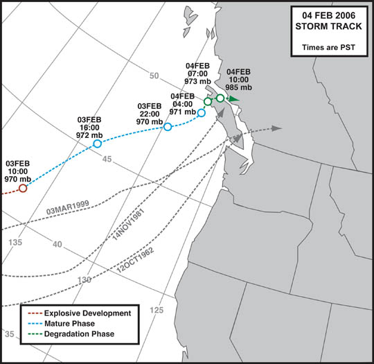
Storm Track

Figure 13: Track for the February 3 - 4, 2006 windstorm, displayed next to the paths taken by past high-wind-generating cyclones. Track and central pressure values are based on maps from the National Weather Service Ocean Prediction Center.

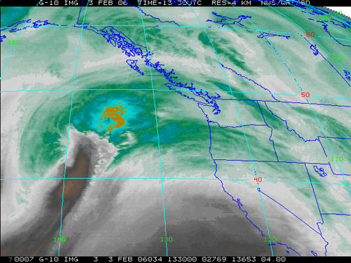
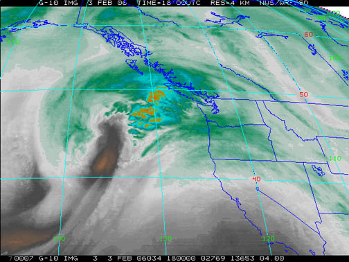
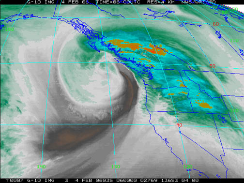
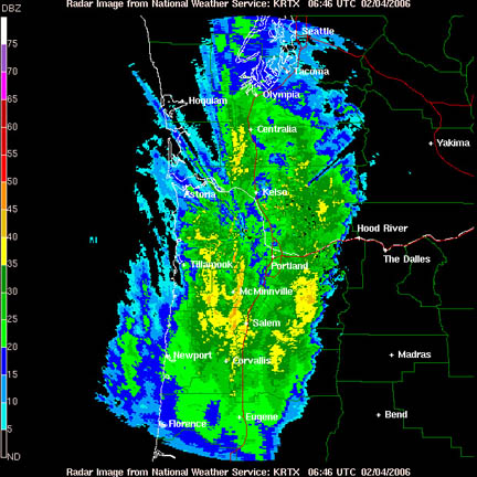
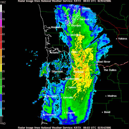
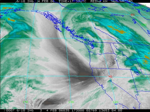
The February 3 - 4, 2006 cyclone developed rapidly outside of 135ºW, deepening from 985 mb (29.09") at 04:00 to 970 mb (28.64") by 10:00 on the 3rd. These rates of fall easily fit within the ~1 mb (0.03") per hour or greater that defines explosive cyclogenesis. After reaching about 970 mb, the cyclone's central pressure reduction more-or-less stopped, and the storm spent about 18 hours hovering around 968 to 972 mb. Upon nearing the shores of Vancouver Island, the low's forward movement slowed significantly, and the system filled rapidly, two factors that likely resulted in lower wind velocities over the Northwest.

But perhaps the biggest factor in mitigating a potentially devastating windstorm was the system's track far offshore, and the sudden hook north near Vancouver Island, which carried the low center even further from Washington. The cyclone's center did not cross inside 130ºW until it had passed beyond 47ºN. Had the track been even a little further to the west, this system may not have amounted to much at all.

The paths of some significant windstorms are included in the above figure to help demonstrate just how far offshore the 2006 storm traveled. It is interesting to note that strong winds didn't really start picking up in Oregon and Washington until after about 20:00 PST on the 3rd, which is approximately when the low reached the 130ºW line, a well-known benchmark for estimating a cyclone's high wind potential in the Pacific Northwest.

General Storm Data

Barometric Minima

Table 1, below, lists the barometric minimums for the February 3 - 4, 2006 storm at selected sites. Many Pacific Northwest windstorms have produced significantly lower readings. Like many aspects of the 2006 event, these values are similar to the strong March 3, 1999 and January 16, 2000 gales, but maybe more so to the December 27, 2002 event. The most depressed pressures during the 2006 storm were along the tip of the Olympic Peninsula, and included 29.01" (982.4 mb) at 04:00 on the 4th at Tatoosh Island, and 29.15" (987.3 mb) at Destruction Island at 07:00 on the 4th.

For much of Oregon and some sections of Washington, pressure minima occurred during the arrival of the cyclone's leading cold front. In parts of northwest Washington, further depression of barometric readings occurred as the cyclone's center passed just offshore and into Vancouver Island.

Sources: National Weather Service, Portland and Seattle offices, METAR reports, and the National Data Buoy Center, real-time meteorological data.

Location

Lowest
Pressure

Approx Time
of Lowest Pressure

California:    
Arcata

29.87"

21:53 HRS, 3rd

Oregon:    
North Bend

29.64"

19:55 HRS, 3rd

Astoria

29.45"

00:55 HRS, 4th

Medford

29.69"

22:53 HRS, 3rd

Eugene

29.59"

20:54 HRS, 3rd

Salem

29.55"

20:56 HRS, 3rd

Portland

29.53"

21:55 HRS, 3rd

Washington:    
Quillayute [1]

29.27"

23:53 HRS, 3rd

Olympia

29.45"

22:54 HRS, 3rd

Seattle (Sea-Tac)

29.44"

22:56 HRS, 3rd

Bellingham [2]

29.33"

23:50 HRS, 3rd

     
AVERAGE

29.53"


Table 1 Notes:

[1] Quillayute METAR reports stopped arriving for many hours after 23:53 report, presumably due to power outage. Based on readings at Destruction and Tatoosh Islands, which had their minima occur between 04:00 and 07:00, the value for UIL is likely a bit high.

[2] Bellingham METAR reports missing between 23:50 and 16:50 PST, which likely covers the time period of minimum pressure. The noted value is likely a bit high.

Pressure Gradient Maxima

Table 2, below, lists the maximum gradients for some standard measures during the February 3 - 4, 2006 cyclone. This cyclone had a strong showing on the coast, with the long measure, ACV-TTIW reaching +37.4 mb (+1.10") at 08:00 on the 4th, one of the highest values for any West Coast gradient measure within the period of official weather record. The north coastal section clearly fell under the region of strongest gradient, this the result of the cyclone's far north track.

Gradients for the interior sections weren't unusually strong, save perhaps over northern Washington. Unfortunately the Bellingham data is missing for the critical part of this event. An important measure for estimating the wind velocity potential for the Northern Willamette Valley, the EUG-OLM, gradient, reached +13.7 mb (+0.40") at 07:00 on the 4th.

Cape Arago (CARO) sits in for North Bend, and Tatoosh Island (TTIW) is used in place of Quillayute, which has missing weather observations from the height of the storm.

Sources: National Weather Service, METAR reports, and the National Data Buoy Center.


Location

Max Gradient, mb

Approx Time
of Max Gradient

Coast:    
ACV-CARO

+10.0

02:00 HRS, 4th

CARO-AST

+12.5

05:00 HRS, 4th

AST-TTIW

+20.8

08:00 HRS, 4th

ACV-AST

+20.1

05:00 HRS, 4th

OTH-TTIW

+30.1

08:00 HRS, 4th

Interior:    
MFR-EUG

+6.8

21:00 HRS, 3rd

EUG-PDX

+5.7

06:00 HRS, 4th

PDX-SEA

+10.2

07:00 HRS, 4th

SEA-BLI [1]

MM

MM

AST-DLS

-10.3

20:00 HRS, 3rd

Table 2 Notes:

[1] Data for Bellingham missing for the critical hours of the windstorm.


Pressure Tendencies

Table 3, below, lists the maximum hourly pressure tendencies recorded at eleven key stations during the February 3 - 4, 2006 event. None of these tendencies stand out next to past windstorms. Barometers moved more sharply in Washington, as the cyclone's center passed closer to this state, with some readings fairly strong. The Oregon values aren't particularly uncharacteristic for a typical winter storm.

Sources: National Weather Service, METAR reports, and the National Data Buoy Center.


Maximum Pressure Tendencies for the February 3 - 4, 2006 Storm

Location

Max
Hrly
Fall
mb

Time of
Max Fall
PST

Max
Hrly
Rise
mb

Time of
Max Rise
PST

California:        
Arcata

-1.5

21:00 HRS, 3rd

+2.1

01:00 HRS, 4th

Oregon:        
North Bend (Cape Arago)

-2.7

19:00 HRS, 3rd

+1.9

12:00 HRS, 4th

Astoria

-2.8

20:00 HRS, 3rd

+2.6

08:00 HRS, 4th

Medford

-1.7

22:00 HRS, 3rd

+2.6

02:00 HRS, 4th

Eugene

-1.7

15:00 HRS, 3rd

+1.8

09:00 HRS, 4th

Salem

-1.8

21:00 HRS, 3rd

+2.6

00:00 HRS, 4th

Portland [1]

-2.0

21:00 HRS, 3rd

+2.2

09:00 HRS, 4th

Washington:        
Tatoosh Island

-3.6

15:00 HRS, 3rd

+3.6

10:00 HRS, 4th

Olympia

-3.7

21:00 HRS, 3rd

+3.2

10:00 HRS, 4th

Seattle (Sea-Tac)

-2.9

21:00 HRS, 3rd

+2.7

09:00 HRS, 4th

Bellingham [2]

-3.7

21:00 HRS, 3rd

MM

MM

         
AVERAGE

-2.6


+2.5


Table 3 Notes:

[1] The -2.0 mb fall is the last of two hourly occurrences, the other having happened at 16:00 HRS on the 3rd.

[2] Pressure data missing for a critical part of the storm. The -3.7 mb hourly fall is likely the fastest declension for this wind event, based on trends from other stations. The maximum hourly rise likely occurred during the data hole; +2.1 mb/hr occurred at 20:00 on the 4th, to place a lower bound on what may have actually occurred.


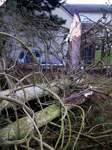
Peak Wind and Gust

Table 4, below, lists the peak wind and gust for eleven key stations in the Pacific Northwest, their direction, and their time of occurrence. "Peak Wind" is a 2-minute average, and "Peak Gust" is a 5-second average. By my own personal methodology, a wind event rates the term "windstorm" when the average peak gust of these eleven stations reaches 39.0 mph (gale force) or higher. The February 3 - 4, 2006 cyclone, even in the new era of 5-second gust (see below), blew strong enough to be considered a moderate windstorm. Moderate windstorms have an average of 45.0 to 54.9, and major windstorms are those that reach or exceed 55.0. Only a handful of storms have made the majors, including December 12, 1995, November 14, 1981 and October 12, 1962.

Of particular interest is how this windstorm compared to some of the others in recent memory. More specifically, how much time has passed since an event of equal or stronger magnitude occurred. With an average peak gust of 46.8 mph, the February 3 -4, 2006 windstorm has been the strongest event since January 16, 2000, which had an average peak gust of 52.5 mph at the eleven key stations used in this comparative data section. The March 3, 1999 windstorm, often cited as the strongest since December 12, 1995 in the modern ASOS era, wasn't quite as powerful wind-wise as its 2000 cousin with an average peak gust of 51.5 mph. Interestingly, a fairly vigorous wind event on January 1, 2006, with an average peak gust of 45.2 mph, had been the strongest gale since January 16, 2000--but the New Year's storm only hung on to this title for a little more than a month!

In the ASOS era, the windstorm that the February 3 - 4, 2006 event most closely approximates is the January 1, 1997 gale that followed a major flood-and-mudslide-producing Pineapple express that wreaked havoc over the New Year's holiday. The 1997 event also had an average peak gust of 46.8 mph, though this system's impact was felt more strongly on Oregon's central coast and generally less so on the Washington coast and in the greater Seattle area. Adjusting to the earlier 1-second gust records of the pre-ASOS era, 46.8 mph is about equivalent to 55.7 mph. Other storms of history that generated a similar 11-station average gust include: January 7, 1953 (55.1 mph), October 26, 1950 (54.9 mph), December 4, 1951 (54.5 mph) and January 19, 1964 (54.1 mph). The 1964 storm followed a similar track to the 2006 event.

For more explanation on how the 5-second and 1-second gust measures play into the kind of storm ranking system I describe here, see "Adjustments to Modern Storms."

Also, peak wind is the highest value noted in the regular and special reports, and may not reflect the true maximum 2-minute average. For example, Portland's actual peak 2-minute wind was 35 mph on the 4th, as noted by the ASOS automatic recording capability. Before ASOS, there wasn't always a means to witness the actual maximum wind, and it was often taken from the regular and special observations. The methodology is done similarly in this table to provide information that is more comparable to the storms that occurred before ASOS (pre-mid-1990s).

Sources: National Weather Service, Eureka, Portland and Seattle offices, METAR reports, and Public Information Statements.

Location

Peak
Wind
mph

Direction
Pk Wnd
degrees

Obs Time of
Peak Wind
PST

Peak
Gust
mph

Direction
Pk Gst
degrees

Obs Time of
Peak Gust
PST

California:            
Arcata

26

220

00:37 HRS, 4th

39

140

20:42 HRS, 3rd

Oregon:            
North Bend

43

270

07:15 HRS, 4th

51

270

07:15 HRS, 4th

Astoria [1]

37

250

07:55 HRS, 4th

59

210

04:19 HRS, 4th

Medford

22

140

22:53 HRS, 3rd

32

250

02:09 HRS, 4th

Eugene

33

190

23:54 HRS, 3rd

46

180

23:44 HRS, 3rd

Salem [2]

24

220

07:27 HRS, 4th

39

260

23:10 HRS, 3rd

Portland

26

220

04:53 HRS, 4th

44

230

00:00 HRS, 4th

Washington:            
Quillayute [3]

25

160

21:01 HRS, 3rd

53

160

23:08 HRS, 3rd

Olympia [4]

30

170

06:34 HRS, 4th

43

170

06:37 HRS, 4th

Sea-Tac

36

200

07:21 HRS, 4th

47

190

07:14 HRS, 4th

Bellingham [5]

29

160

23:53 HRS, 3rd

62

?

08:26 HRS, 4th

             
AVERAGE

30.1

200


46.8

206

 
[1] Peak wind at Astoria is the last of several occurrences, including out of 180 degrees at 00:55 PST.

[2] Peak wind at Salem accompanied by a thunderstorm.

[3] Maximum wind and gust for Quillayute may have been higher. Reports stopped being received from the station for several hours after the 23:53 observation, near the time that winds had started gusting above 50 mph.

[4] Peak gust for Olympia is the last of two occurrences, the other having occurred out of 220 degrees at 23:52 on the 3rd, likely the result of cold-frontal passage.

[5] Bellingham METAR reports missing between 23:50 and 16:50 PST, which covers the time period of maximum winds. Given the maximum gust noted by the NWS, peak 2-min wind was likely significantly higher than 29 mph. It was probably more like 40 - 45 mph.

Peak Gusts in the Seattle Area: 04 Feb 2006 Not as Strong as Recent Events

Table 5, below, lists Seattle-area peak gusts, in mph, for recent storms. The data reveal that, for the greater Seattle area, the February 4, 2006 windstorm didn't quite have the punch of some other events in recent memory. The December 27, 2002 cyclone struck much of the area considerably more strongly, save at West Point. And, of course, the January 16, 2000 and March 3, 1999 windstorms are a significant cut above even the December 27, 2002 event.

Storm
Tacoma McChord
SeaTac Airport
Renton
Boeing Field
West Point
U of W ATG
Everett Paine
Average
04FEB2006
47
47
44
47
66
48
52
50.1
01JAN2006
41
49
40
40
54
40
45
44.1
25DEC2005
40
38
38
35
48
35
48
40.3
27DEC2002
51
52
49
48
59
56
58
53.3
16JAN2000
60
52
53
54
69
55
60
57.6
03MAR1999
55
60
51
52
68
MM
57
57.2

For Washington's Northwest Interior, however, the story was quite different. Because the December 27, 2002 low center tracked over the region, winds weren't particularly strong during this event, so a look further back in time is required to find a comparable event to the 2006 storm. With a peak gust of 62 mph at Bellingham, the February 4, 2006 windstorm was a close match for the 63 mph recorded on March 3, 1999 and somewhat behind the 66 mph burst on January 16, 2000.

Last Modified: February 23 2006
Page Created: February 6, 2006

You can reach Wolf via e-mail by clicking here.

| Back |