Two Weeks of Storms, November 10-24, 1983
and the Thanksgiving Day Windstorm

a perspective by

Wolf Read

Introduction

November, 1983, in general, was stormy. In a pattern typical for windstorm generation, a series of atmospheric waves developed to the southwest of Oregon, raced northeastward, and raked the Pacific Northwest with high winds and rain roughly every 3 to 4 days, starting November 10th. From November 10th to 24th, there were four main events. From my Renton, Washington, perspective, the storms generally grew in strength over those two weeks, with the coup de grace delivered on Thanksgiving day. However, the local effect is pronounced in some of these storms, and this sample of the four windiest storms of November 1983 offers a nice example of the idea that one region's big storm can be another's minor one. Indeed, the storm system of November 10th--the first in the series--may have been the strongest of them all, but it stayed far offshore compared to others, weakening its effects inland.

Figure 1, below, shows the daily peak gust at SatTac airport. This clearly shows a gradual progression to stronger windspeeds over the series of storms for the region that was my former home (as the crow flies, my residence was about 5 miles due west of the SeaTac Aiport, at the most). Locations further south that fell under the influence of these storms have different profiles. See Table 7 in the Appendix at the end of this document, for more discussion on the variance typically seen in Pacific cyclone wind speeds. Source: National Climatic Data Center.


The November 10, 1983 Storm

After enduring a December, January and February that largely weren't interesting wind-wise (save maybe the strong easterly winds of December 23-24), I longingly wrote a few details about the Novermber 1983 storms in my weather journal on February 27, 1984. Here's what I recalled about the November 10th storm:

"The wind blew a very large branch off of a birch [in the greenbelt out back, called "The Forest"] and when it crashed on the ground it shattered across the rocks and across the carport to have its tip land in the road. It caused no damage.

"Lots of birch and alder branches cracked off and covered the road and the trailers parked there. Hundreds of cottonwood leaves ripped off and coated roofs and streets. Three or four large cottonwood branches snapped off, but did no damage. Large alder branches were lying all over the trail and a few landed in the road.

"During the height of the gale, you could watch birch and alder branches sail off of the trees and land on condo roofs or in the grass and on the road. Some of the branches hit the trailers, making loud popping and banging sounds when they hit.

"Two Douglas firs hit a house [in the wider neighborhood in SE Renton, WA]. One caved in the roof partially and the other flattened a garage, taking a pickup with it. A branch shattered a skylight, doing $500.00 in damage [this was my 9th grade math teacher's skylight--she told the story in class the following morning].

"That's about all the damage I found out about.

"The pressure fell rapidly in the storm, and dropped to a low of 29.19" and the temperature stood at 50º during the whole gale. The wind probably gusted within the 40-55 mph bracket, thus causing lots of damage. But here are the gusts I saw--I missed a lot because I went outside during the gale:

"I saw one blow past 40, but I was half asleep and couldn't tell exactly where it went. I mainly saw gusts between 30 and 40 mph--here are some I remember: a couple of 35 & 36s, a 37, and lots of gusts between 30 and 34.

"There wasn't much rain during the gale, but it did rain after and it rained heavily when it did."

 I still remember that trip outside to The Forest--I had decided that being glued to an anemometer every time a storm hit was only part of the fun. Sometimes, I wanted to go out and experience the full force of a Pacific gale.

Dawn had just broken, and ragged, low clouds were illuminated a deep blue. I climbed upon the rock berm [the condominum complex was incised into a hill--the rocks held the soil, and The Forest, in place, and this wall of andesite reached about 15' high in spots] in the unusually warm gusts, and stood on the edge of the woodlot as the wind ripped over me. The trees roared in the gale, bending like reeds, and bounced against each other. Branches broke and fell. A piece of dead birch slammed against a carport roof behind me. I jumped, the crash was so loud.

Then I heard a tell-tale roaring in the distance, almost a hum: the sound of a gale ripping through miles and miles of powerlines that surrounded the condominum complex. The roar became a scream, and the entire woodlot moved as one. Twigs rained down around me. The gust wrapped itself around me, and pulled hard. It very nearly yanked me off the rocks. I crouched to keep my balance.

After the strong blast, I wondered how high it registered on my anemometer. I climbed down and ran home as the trees again roared around me. I couldn't stand the thought of missing any more wind readings!

November 10, 1983: Storm Data

Table 1, below, lists the peak winds for the November 10, 1983 storm for eleven key stations. Due to a track fairly far offshore, this system generated peak winds with a strong easterly component. Such storms are sometimes called "southeast sucker" type systems. The strongest winds during these storms tend to favor those locations with good exposure to southeast winds, such as Bellingham. Portland and Sea-Tac, which are exposed to easterly "gap" winds, were favored early, as the storm moved up the coast, and their maximum winds were from a southeast to east direction. Many Cascades foothills locations are also subject to these winds, including the Renton Highlands, Enumclaw and North Bend, WA. Arcata had a decent winter storm from this cyclone, with a heavy-rain producing front at the time of maximum winds.

Source: Data is from the National Climatic Data Center, unedited surface observation forms.

Location

Peak
Wind
mph

Direction
Pk Wnd
degrees

Obs Time of
Peak Wind
PST

Peak
Gust
mph

Direction
Pk Gst
degrees

Obs Time of
Peak Gust
PST

California:            
Arcata

37

220º

10:26 HRS, 10th

46

210º

10:27 HRS, 10th

Oregon:            
North Bend

29

160º

13:55 HRS, 10th

39

160º

13:55 HRS, 10th

Astoria

28

190º

21:50 HRS, 10th

46

180º

20:58 HRS, 10th

Medford

31

130º

10:53 HRS, 10th

47

130º

10:52 HRS, 10th

Eugene

17

170º

13:50 HRS, 10th

31

170º

09:39 HRS, 10th

Salem

18

170º

19:50 HRS, 10th

32

180º

19:34 HRS, 10th

Portland

28

110º

03:55 HRS, 16th

35

090º

04:18 HRS, 10th

Washington:            
Quillayute

23

040º

02:56 HRS, 10th

52

160º

20:11 HRS, 10th

Olympia

22

190º

20:52 HRS, 10th

33

190º

20:50 HRS, 10th

Sea-Tac

22

110º

10:51 HRS, 10th

36

130º

13:36 HRS, 10th

Bellingham

23

150º

23:52 HRS, 10th

60

160º

23:07 HRS, 10th

             
AVERAGE

25.3

149º


41.5

160º


The November 13, 1983 Storm

This storm was missed in the bustle of life, and I have no record of it in my journals. Apparently, it just wasn't exciting enough in Renton to keep me interested. Maybe I was distracted by a role-playing game, or the TV, and didn't notice wind gusts high enough on the anemometer to keep my interest. In terms of tree damage, it apparently wasn't that impressive, probably because the November 10th storm had stripped the trees of most of their weak branches and twigs, as well as the leaves from the deciduous species, making them have less resistance to the wind.

November 13, 1983: Storm Data

Table 2, below, lists the peak winds for the November 13, 1983 storm for eleven key stations. North Bend's peak gust occurred during a band of heavy rain with imbedded thunderstorms that rolled through between 02:43 and 04:51. Total rain midnight to 03:48 was 0.44". These thunderstorms also generated a peak 1-minute wind of 23 mph. Later in the day, another round of thunderstorms struck, and produced the final peak wind of 23 mph for the day (there were five occurrences on the 13th), with a gust to 38 mph, and a possible funnel cloud north of the station. Arcata had a very similar sequence to North Bend, with the peak gust occurring during early morning thunderstorms, and peak winds during a second round of thunderstorms in the afternoon. Astoria had a thunderstorm at 11:32, which produced southeast winds of 23 mph gusting to 32. Eugene's strong peak gust occurred during a brief heavy rain episode that dumped 0.47" at the station between 05:00 and 06:00--this was probably from the same band of rain that contained North Bend's thunderstorm two hours earlier. The thunderstorms and heavy showers seems to have given this storm its punch. The concentraiton of strongest convection south of Quillayute-to-Seattle seems to have spared a much of Western Washington stronger winds.

Source: Data is from the National Climatic Data Center, unedited surface observation forms.

Location

Peak
Wind
mph

Direction
Pk Wnd
degrees

Obs Time of
Peak Wind
PST

Peak
Gust
mph

Direction
Pk Gst
degrees

Obs Time of
Peak Gust
PST

California:            
Arcata

30

280º

13:30 HRS, 13th

38

260º

04:33 HRS, 13th

Oregon:            
North Bend

23

210º

16:39 HRS, 13th

46

170º

03:10 HRS, 13th

Astoria

35

230º

17:05 HRS, 13th

55

170º

13:29 HRS, 13th

Medford

18

140º

01:50 HRS, 13th

33

140º

03:26 HRS, 13th

Eugene

26

170º

13:01 HRS, 13th

48

180º

05:04 HRS, 13th

Salem

28

180º

06:52 HRS, 13th

44

180º

06:44 HRS, 13th

Portland

31

190º

15:48 HRS, 13th

39

190º

17:38 HRS, 13th

Washington:            
Quillayute

15

230º

23:29 HRS, 13th

29

140º

11:27 HRS, 13th

Olympia

31

190º

16:56 HRS, 13th

49

190º

16:55 HRS, 13th

Seattle

22

220º

22:34 HRS, 13th

39

180º

17:30 HRS, 13th

Bellingham

17

160º

20:52 HRS, 13th

30

160º

14:53 HRS, 13th

             
AVERAGE

24.6

200º


40.9

178º


The November 19, 1983 Storm

On February 27, 1984, I recalled this storm as happening on Nov 20th, probably because it hit during the night of the 19th. Note the fairly high gust of 43 mph on Nov 20th at the SeaTac in Figure 1 above--the mark of the storm's fading winds in the early morning hours. Interestingly, I felt that it was weaker than the Nov 10th storm, probably for the same reasons cited during the Nov 13th storm: the first event had knocked down most of the tree parts waiting to go. It would take a very significant storm to produce as much tree damage as occurred on November 10th. Here's what I wrote in my journal:

"The gale wasn't as strong as the other one, but it's worth recording.

"Gusts to 50 mph were reported at Hoquiam and the Evergreen Point Floating Bridge. The highest gusts I saw were:

"One 38, three 37s, four 36s and seven 35s. There were a whole lot of gusts between 30 and 35 mph. The wind probably gusted to 40 or 45 in The Forest [estimation due to the fact that my anemometer, though it was on a 2nd story roof, was still below the height of many of the trees, thus it was obstructed to a degree].

"Damage was minimal: only broken branches off of alders, birches and cottonwoods.

"There was lots of rain in this gale. The pressure dropped to 29.10" and at Hoquiam it dropped to 29.02". I don't know why, but the second storm in a group of storms almost always seems to be the weakest.


If this was the "second" storm this month, then it obviously wasn't the last...

November 19, 1983: Storm Data

Table 3, below, lists the peak winds for the November 19, 1983 storm for eleven key stations. Astoria's peak winds arrived during a strong pressure surge, with the barometer leaping from 29.12" (986.0 mb) at 18:00 PST to 29.24" (990.2 mb) at 18:50. Judging by the peak wind velocity and direction for Quillayute and Bellingham, this particular cyclone dove ashore in Washington, and passed south of the two northern stations, thus sparing them the strong winds seen in Olympia and Seattle. The low center moved in just north of, if not right over, Hoquiam, where the barometer fell to 29.04" (983.4 mb) by 18:58, and, after a bout of southerly winds, a heavy surge of west to west-northwest winds roared in at 19:31 and quickly escalated to 64 mph in gusts by 19:51. The temperature fell from 51º F at 18:58 to 46º by 19:51, and the pressure surged from 29.08" (984.8 mb) at 19:51 to 29.21" (989.2 mb) at 20:52. It appears that Hoquiam suffered the assault of a strong bent-back occlusion at this time, another sign that it was near the low's center.

In terms of path, but not in the strength of the bent-back occlusion, a similar situation to the November 19, 1983 event happened on December 27, 2002, with approximately equivalent wind speeds among all the stations below. For a reference to the journal notation of a 29.10" minimum on my personal barometer during the 1983 storm, the minimum pressure at Sea-Tac was 29.12".

Source: Data is from the National Climatic Data Center, unedited surface observation forms.

Location

Peak
Wind
mph

Direction
Pk Wnd
degrees

Obs Time of
Peak Wind
PST

Peak
Gust
mph

Direction
Pk Gst
degrees

Obs Time of
Peak Gust
PST

California:            
Arcata

17

270º

14:52 HRS, 19th

24

240º

18:50 HRS, 19th

Oregon:            
North Bend

35

260º

16:24 HRS, 19th

48

240º

16:28 HRS, 19th

Astoria

40

250º

18:40 HRS, 19th

61

250º

18:47 HRS, 19th

Medford

14

310º

19:50 HRS, 19th

20

310º

19:59 HRS, 19th

Eugene

29

180º

10:47 HRS, 19th

39

180º

10:44 HRS, 19th

Salem

28

210º

14:38 HRS, 19th

38

180º

16:38 HRS, 19th

Portland

25

190º

17:50 HRS, 19th

38

180º

18:54 HRS, 19th

Washington:            
Quillayute

13

310º

20:54 HRS, 19th

25

310º

20:17 HRS, 19th

Olympia

25

190º

18:39 HRS, 19th

44

210º

21:07 HRS, 19th

Seattle

29

190º

23:46 HRS, 19th

47

210º

22:58 HRS, 19th

Bellingham [1]

15

020º

19:53 HRS, 19th

20

020º

19:53 HRS, 19th

             
AVERAGE

24.5

216º


36.7

212º


Table 3 Notes:

[1] The wind wasn't strong enough in Bellingham for gust to be noted. A peak was estimated from the maximum 1-minute wind using the standard 1.3 gust factor.


The Thanksgiving Day 1983 Windstorm

For Western Washington, the Thanksgiving Day storm of 1983 was a fairly powerful event. But in sheer wind strength, this storm does not quite match the bigger blows of 1962, 1981, 1993 and 1995. And, indeed, for those who endured the November 10th storm in SW Oregon, they'd probably balk at the idea that the Thanksgiving Storm was the more promenant one of the month.

The Thanksgiving Day windstorm stands out sharply in my memory because of the day that it happened. Many Thanksgiving dinners were ruined as electricity quit at hundreds of thousands of households across the Pacific Northwest. Disruption to the power distribution system was so great that power even failed at Wenatchee, where winds were light [1]. Also, it was the only storm of the series to strike in the daylight, making its entire progression visible, instead of being cloaked in the sleepy dark of night.

Not only did the Thanksgiving Day windstorm get mention in my journal, it also got its own hand-made book. In other words, this storm stood out above all the rest that November. Here's a trimmed-down version of my little "book" (originally written February 28, 1984):

The Windstorm of Thanksgiving 1983

Chapter # 1: The Beginning

Out in the Pacific sat a low that was rapidly moving toward the Oregon Coast and was supposed to raise hell down there when its front hit.

The problem with this is that the low decided [heh] it would rather go through Washington, and it veered northward. And boy, that sucker almost moved right over us.

At 5 AM (the time I woke up) the pressure was reading 29.18" and falling rapidly. In fact, the pressure was falling so fast I could watch the needle move, just barely. That was the fastest pressure drop I have ever seen.

I wonder if the weathermen thought that the rapid pressure drop would mean that a windstorm was going to strike? They must've figured that the low was still heading into Oregon because the weather report at the time called for rain in the afternoon and winds of 10-20 miles per hour. But, something at the time told me things would be different.

Well, at the time, the wind was gusting to 30 mph with occasional gusts higher. The highest gust was about 33 mph. There seems to be an eerie calm before one of our windstorms, like the one I remember that occurred before the windstorm of Nov 14, 1981. Since it wasn't calm and the pressure was falling I figured that if there was a storm, it wasn't going to hit quite yet.

The sky at 5 AM was very dark, so I really couldn't tell what kinds of clouds were up there, but I saw some clearings between the fast moving clouds.

I waited for awhile, listening to the weather-radio from time to time to see if the report had changed. Nope. It hadn't., It was the same old 10-20 mph.

I wondered what they [the weather officials] were doing down there as I watched the pressured drop to 29.10" at 6 AM.

The winds were still gusting to 30 mph, which meant their report was wrong, even then.

When I looked at the sky in the very feeble light of dawn I saw some stratus with larger clearings between them scudding across the sky. The wind was roaring through the trees pretty loudly too.

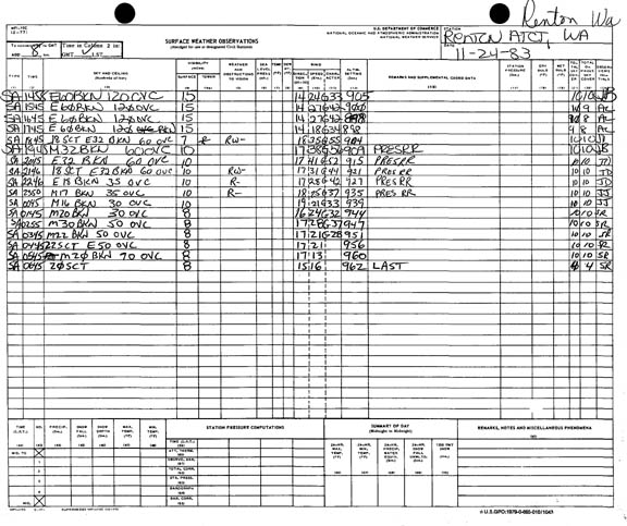
The pressure was reading 29.00" at around 7 AM. It was the lowest I had seen in more than a year and as things turned out, it would drop lower.

Finally there was light outside. I could see scraggly, fast-moving, stratus clouds blowing toward the NE. They were really torn up and a blue sky showed between them. Sometimes a large clearing would reveal high, fast-moving cirrus clouds. The clearings were getting bigger as time progressed and the wind didn't seem to be dying either.

The weather report was still the same.

Sometime between 8 and 9 two things happened.

The first thing that happened was that the pressure dropped to its lowest and steadied at 28.94." Sea-Tac had 28.97" so I accept that as the actual low because my barometer was probably a little off at the time. Quillayute had a low of 28.80" and Astoria dropped to 28.88". I'm sure when this happened the weathermen got a little worried.

The second thing that happened (I think at 9 or 9:30) was the weather-radio alarm went off.

They gave us high wind warning for the western half of Washington.

That meant we were supposed to get winds of 20-40 mph with occasional gusts higher within 12 hours. It was going to hit much sooner than 12 hours.

Finally they warned people and they were almost too late.

At the time the sky was mostly clear with occasional fast moving stratocumulus clouds flying by with lots of white wispy cirrus clouds overhead. To the south and west were more clouds but no sign of the front that I figured should be moving on us fast.

The winds were still occasionally gusting past 30 mph so I figured I had a long wait. But I stayed by my anemometer just in case there were any surprises.

I noticed the air had a different quality to it. It seemed foggy or murky, but it couldn't be foggy with this wind blowing. Another thing was that the sun shone clearly and brightly through the clearings and it gave a weird feeling around the place. There were no seagulls flying over to Lindburgh High School or any other animal was not to be found. It was completely strange and I will never forget it.

Chapter # 2: Strike!

At 10:00 AM I was sitting on the couch waiting for the windstorm to strike. This was one of those rare time in which the windstorm occurred in the day, not in the night, so I wouldn't fall asleep waiting and I could see what was happening to the trees.

At this time, the skies and the winds were the same: partly cloudy and gusts to 30 mph. The pressure stood at 28.94" and occasionally fluctuated up to 28.95" or down to 28.93" every once in awhile.

It did not take long for me to find out another thing that was rare about this windstorm.

There would be no calm before the storm.

At 10:10 the skies got cloudier. So I jumped up and ran to the master bedroom and looked out the west-facing window. There were a bunch of small stratocumulus clouds to the SW, a bit more packed together than the ones over us and some high cirrus clouds were moving rapidly above the house. The fronts usually came from the southwest and were usually proceeded by a lot of altostratus clouds and I could only see one patch of it moving rapidly to the north. I should've took this as a warning because this is how I thought it would look like before a windstorm and I had even written it down.

I ran back into the living room and listened to the weather report to see if anything had changed: but nothing had. I noticed that it was darker outside.

I got up and walked to the anemometer and looked out the window. A thickening layer of dark stratus was overhead and it was moving fast.

I knew I would only have to wait just a little bit now. It seemed to be upon us now.

At 10:15 AM the first part of the storm struck. It came in fast and deadly (for insects) with the first two gusts at 37 and 36 miles per hour. A very heavy rain poured down just as the gusts hit.

This happened very quickly and I was almost caught by surprise.

The rain poured down more heavily than any thunderstorm that I had seen. It reminded me of a hurricane because the drops of rain were extremely large and they whipped about in great white sheets that drenched everything in seconds. Rain spattered all over the window [which was protected by a deep eave] and the sheets blocked vision pretty well. Water was pouring everywhere not too long after the storm hit.

While the rain came down from the medium grey sky, the wind did not blow that strong. It mainly gusted between 30 and 40 mph.

Not too long after the 37 and 36 mph gusts I saw a 38 and then a 35 mile per hour gust. About five minutes after the rain started two 39 mph gusts and a 40 mph gust blew past. Then it gusted to 42.

For some people 42 mph may not sound like much, but any wind of 39 mph or above is gale force and can cause damage (mainly to trees).

The trees had gone mad with all their leaves ripping off in great swarms and branches bouncing and clashing noisily. Sometimes a large branch would crack off and slam into the ground or on a roof.

The hemlock was swaying and bobbing about with all its south facing branches pointing east and west as the wind hit them.

Between 10:20 and 10:30 AM the above weather continued, but with a little more intensity. There wasn't any lull in the wind or rain and things were weakening fast.

Around 10:30 something interesting happened: the power went out.

This did surprise me. The only other time a windstorm had knocked the power out was on February 19, 1981, and that one was a powerful one, knocking down four trees in our forest, one falling on a fence. Enough talking about that one now, after all this is the Nov 24, 1983 windstorm.

The other problem about the power going out is that we had two pies in the oven, and the question, "Can the work crews restore the power in time to cook the turkey?" This was a major windstorm and the work crews would be busy.

The wind continued to buffet the area and the rain continued to pour down with its increased intensity until 10 to 15 minutes after the power zonked out. That's when the rain started to stop, the clouds started to thin, and the winds started to increase. A new peak gust roared by. It was 45 mph.

Then, the sky partially cleared and the stronger, steadier winds set in. There was going to be some strong gusts now!

When the sky cleared, I tapped the barometer and it was 28.99" and rising. Here come the winds, I thought.

We had all kinds of gusts into the forties which included a 44 mph gust. Things began to get crazy now.

The cottonwoods were bent so far they looked like they were going to fall. Their branches bent, snapped and clashed about in the gale.

The birches were doing the same, but they were a little straighter (because the were smaller, had no leaves at the time, and were less flexible). But they were losing twigs as fast as Dad spends money.

The alders just swayed and bounced about, occasionally losing a branch in the gusts.

The hemlock was bent like a whip and all its south facing branches were pointing north with the east and west facing branches. It looked as if someone had sawed all the branches off but the north-facing ones.

After a while more of the brief gusty clearing grey stratus clouds set in to cover the sky in a thick blanket. The winds continued strongly and they were going to be at their strongest point soon. The power was still out.

Since it was almost completely quiet because of no power, I could clearly hear the wind roar through the trees like a jet. When the wind whistled and whined past the house, it roared through the chimney like a lion. The house creaked and cracked in the gusts and the balcony door shuddered in the near 50-mile-per-hour gusts.

Every one in a while, the whole house would shudder as a long, steady gust blew by. The windows would pulsate inward sometimes as if they were going to shatter.

Leaves and twigs occasionally flew by the windows and a few landed on our balcony.

I saw two 43 mph gusts and looked at the swaying trees and decided to go to The Forest.

Chapter # 3: The Forest

I whipped on my coat, grabbed my air rifle (just in case), and picked up that ol' tard, Alec [my small-standard dachshund]. Then I took one more look at the anemometer as a large gust blew past. It reached 38 mph. I turned around and headed for the door, quickly so I wouldn't want to run back to the anemometer as another gust hit.

When I opened the door the wind blew in with a strong, cold gust. I walked out and had a little trouble closing the door as the wind continued at gale force. I finally yanked it closed.

When I got to the bottom of the stairs and turned south toward the low rocks that lead to The Forest, the gusts hit me at their fullest and it was very hard walking in the wind. At least it wasn't raining because if rain was coming down in that kind of wind, it would sting like hail.

The small trees that were planted in front of the buildings swayed and bounced in the gusts. The small brown street lamps bounced back and forth, making little ticking sounds as they did so. Cottonwood leaves flew high in the sky, swirling, flipping. Some of the leaves stuck to my coat.

When I reached the rocks I stopped and stared at the three cottonwoods at the corner of the fence. Their tops were point directly northwest, and they were whipping up and down like a sea-serpent moving through the water, unbelievably. The only other time I had seen them sway like this was in the gale of the 10th. Leaves tore off of the trees like birds, one by one, or a while warm of them all at once.

I dropped Alec on the grass above the rocks and checked to see if my air rifle was loaded. It was.

So I climbed up the rocks and saw Alec running up the hill, with his ears down, of course (because of the roar). Then I turned east and walked along the rocks, toward The Forest.

The apple tree (not too far from the edge of The Forest) was doing a weird jig in the howler and the larger--if not biggest--cottonwoods were in a steady, roaring sway as another of the many gusts whipped by.

Leaves and twigs blew by me as I approached closed to the forest. Already trees were swaying to my right. Alec followed closely, running.

I entered the southern part of The Forest just as a huge gust hit. This part of the forest had mostly birches and they bounced back and forth with their branches clashing, some even snapping off to fly through the air and land on the forest floor or into the street nearby. Some of the branches sailed far enough to slam into one of the condo's roofs.

The nearby large cottonwoods continued to sway with a branch or two cracking off now and then. One large one landed into a leaf pile. Another larger branch smashed into a carport roof with a loud bang. Twigs landed silently.

I walked along the trail and noticed that a birch lost a huge branch that was 5-6" in diameter and more than 10' long. It was lying in a small sticker bush patch.

No trees had fallen--only large branches had cracked off. I had not checked the northern part of the forest and I decided not to go yet. I could see what happened later. So I turned around, with the wind a-roarin', and walked home. Alec half walked half ran.

When I got home, I started to watch the anemometer and record various 40 mph gusts. Then one gust thundered across our roof. It registered 47 mph, the peak gust that I saw. I suspect the wind gusted higher--I had missed some gusts when I went to The Forest, and Sea-Tac had a peak gust of 54 mph.

Another thing happened when I came home, too. The power zapped back on at 11:45 AM. One hour and fifteen minutes later. We were going to have turkey.

After a while longer of watching the 40 mph+ gusts on the anemometer, I decided to do another forest check.

This check revealed a few more large branches down and a birch tree snapped in half in the northern part of the forest. It landed on a cedar wood fence, doing no damage.

After that, I watched the dying gusts of the windstorm. The winds gusted to and over 40 mph for four hours more and then it almost calmed down completely. After about an hour of dead calmness, two blasting gusts struck. These would be the last strong gusts of the storm. They registered 37 and 36 mph on the anemometer. Interestingly, the storm had also started with a similar set of gusts.

Chapter # 4: Destruction

Here are some of the things that happened during the windstorm:

First, around here:

An alder one and a half feet in diameter snapped at two feet above the ground and landed on the eastbound lane of Puget Drive, doing no damage. It just blocked the lane for an hour or two. Another smaller alder fell nearby, but it did nothing.

A medium-sized alder in the Power Lines lost its top in the gale. When the top hit the ground, it sank one foot into it, throwing mud every which way, and then cracked in two.

Also in the Power Lines, a willow split at the four-foot-level and sheared two other trees of some of their branches as it fell. Thus, only tree damage was done.

During the wind, boards and such were blown about at the new construction site at the Power Lines.

At my condo complex, an alder with huge branches lost one in the gale. The branch was well over 30 ft long and about one foot in diameter. It almost hit one of our condos and it split in three sections when it slammed into the ground.

Second, other places...

At the [Renton Public] library huge 10-20 foot branches snapped off of the nearby cottonwoods in the height of the storm. The branches slammed into the roof of the library and landed all over the sidewalk, making ominous crashes as they hit. There was a little fence damage.

One rather large alder came down at the Cedar River Park. It fell into the swollen Cedar River and floated down stream.

At Seward Park [in Seattle], four trees fell along the nature trail. One was a Douglas fir which snapped about 30 feet off of the ground. Another one was a hemlock and one was a cedar. A silver maple did not fare too well either. Along a branch in the trail a large birch gave way and smashed a fence. So much for the fence.

At west Seattle, where the winds topped 60 miles per hour, there was a lot of window damage and shingle damage. Most of the damage occurred to the houses that were along the water front because the wind whipped 6-10' swells which, of course, slammed into the houses.

At a nearby construction site, lots of boards were thrown about and got imbedded into the ground or slammed into nearby houses. This did not help the houses' windows either.

In some places in West Seattle the power was out for a day and a half.

At Seattle, a madrona--a very large one--fell and smashed a garage into splinters and crushed a car. Some of its branches got imbedded into the car's trunk and engine.

Also at Seattle, a Douglas fir cut a mobile home in two as it came crashing down. No one was injured.

At Sea-Tac, where the winds gusted to 54 mph, a helicopter fell to its side.

The Toledo airport had a hangar get damaged and three planes flipped over. The winds there gusted to an estimated 70 mph.

All along the Sound telephone poles blew down and stop lights blew off of wires. Lots of billboards were bent and twisted out of shape by the 60 mile-per-hour winds and a tree went down on almost every block.

The End

The peak gust of 54 mph that I mentioned in the above account for Sea-Tac was actually the peak fastest mile. Sea-Tac had a maximum instant gust of 62 mph. This is considerably higher than the 47 mph that I witnessed on my anemometer, which was located maybe five miles due east of Sea-Tac, at nearly the same site elevation. A peak gust of 64 mph struck the Renton Airport, which was even closer to my location, but down in the Kent Valley. Peak winds were due south, if not a bit to the south-southeast, at the official locations. Trees, a small hill and a two story building stretched south and southeast of my wind sensor, and probably contributed to slowing the wind at my anemometer site. My clearest vantage was south-southwest to west. Of course, I missed a fairly large window of wind readings--probably 30 to 45 minutes, during the peak wind times at the official locations. I left after 10:30 and didn't get home until about 11:45. Below is a copy of Renton's surface observation form. Times on the form are in GMT, which is +8 hours from PST. Renton's peak gust of 56 knots (64 mph) happened at or before 19:45 GMT, or 11:45 PST (wind speeds are in the middle of the form; the first number represents direction times ten in degrees, the next is a 1-minute average in knots and the final is gust in knots). Sea-Tac's peak was at 11:02. Note the peak 1-minute wind of 41 knots (47 mph) at 12:45 PST for the Renton Airport--that sustained reading was equivalent to the peak gust that I observed on my own anemometer!

Some Photographs of Thanksgiving Day 1983 Windstorm Tree Damage

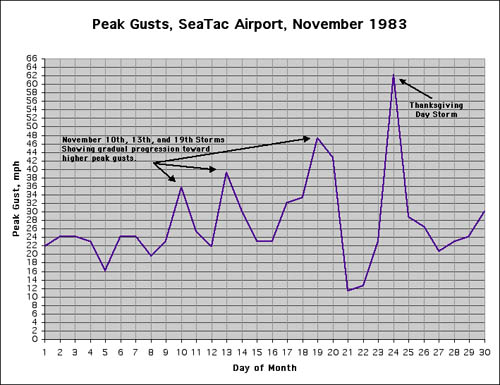
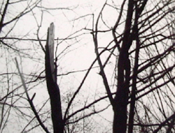
The photo to the left shows a red alder tree, Alnus rubra, from the Power Lines region that lost its top in the gale. This was a healthy tree. In a manner not atypical of alders, when this tree broke, a large, pointed chuck sheared from of both the top and bottom sections, then speared the ground--or, quite possibly, the top struck the ground with such force that it caused its pointed end to shear off. The spear was so firmly planted in the ground that I couldn't remove it. This chunk, or "alder spear" as I often called them, is depicted in the photo below.

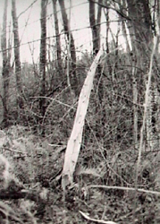
I've seen these spears a number of times--alders broke similarly in the December 22, 1982 storm (which one day will be detailed on this website), and the January 16, 1986 windstorm (in the latter case, the poor tree produced two chunks!), for instance. I suspect the creation of these spears must be a product of the nature of alder wood, for I have not seen the development of these spears in birch, cottonwood, nor any of the softwoods. It occasionally happens to bigleaf maples.

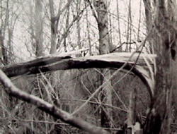
The photo at the lower right shows a broken scouler willow, Salix scoulerana, from the same woodlot in the Power Lines as the broken alder. Other nearby woodlots had no damage. It is not too unusual to find broken trees concentrated in small regions, with little damage between. Whether this is due to localized higher wind speeds, less obstructed wind exposure, or a general weakness of the trees in one spot due to disease or insect attack, I haven't determined. Though, it is conceivable that all three of these ideas, and probably others, each play a role in different storms. I'll write more about this when I cover the tree damage from the January 1986 train of storms, for these systems produced some of the most striking examples of damage localization I have seen, save maybe for the December 28,1990 northerly gale in the Puget Lowlands (which will also deal with this topic).

General Storm Data

Minimum Pressures and Maximum Gradients

Table 4, below, lists the lowet barometric pressures achieved during the Thanksgiving Day Storm for 11 Pacific Northwest locations. The close association in time of pressure minimums is the signature of a low with a NE motion as it made landfall in Washington. Note that the minimums at Astoria, Olympia, Seattle and Bellingham are lower than those recorded during the great November 14, 1981 windstorm. The 29.08" 11-station average minumum pressure marks a fairly deep system. This value is lower than the 29.24" average minimum produced by the Inauguration Day storm of 1993, and the 29.37" average produced by the November 15, 1981 event, two systems that followed similar paths to the Thanksgiving Day gale of 1983.

Source: Pressure data is from the National Climatic Data Center, unedited surface observation forms.

Location

Lowest
Pressure

Approx Time
of Lowest Pressure

California:    
Arcata

29.53"

04:00 HRS, 24th

Oregon:    
North Bend

29.15"

05:00 HRS, 24th

Astoria

28.82"

08:00 HRS, 24th

Medford

29.39"

06:00 HRS, 24th

Eugene

29.16"

06:00 HRS, 24th

Salem

29.11"

06:00 HRS, 24th

Portland

29.08"

07:00 HRS, 24th

Washington:    
Quillayute

28.81"

10:00 HRS, 24th

Olympia

28.92"

09:00 HRS, 24th

Seattle (Sea-Tac)

28.97"

09:00 HRS, 24th

Bellingham

28.96"

11:00 HRS, 24th

     
AVERAGE

29.08"


Table 5, below, lists the maximum pressure gradients achieved during the Thanksgiving Day Storm for 10 Pacific Northwest measures. These are all strong readings, but none are records. Gradients across Washington generally peaked several hours after pressure minimums, which generally resulted in a surge of strong winds long after the initial frontal passage as described in my above anecdote.

The EUG-PDX gradient of +10.0 mb (+0.30") is one of the strongest in history, but falls short of the +13.7 mb (+0.40") produced by the cyclone of October 2, 1967, the +11.4 mb (+0.34") value from the January 10-11, 1988 storm, +10.5 mb (+0.31") from the December 22, 1955 cyclone, and the +10.3 mb (+0.305") gradient achieved during the December 15, 1977 windstorm.

Source: Pressure gradient data is calculated from hourly readings obtained from the National Climatic Data Center, unedited surface observation forms.

Location

Max Gradient, mb

Approx Time
of Max Gradient

Coast:    
ACV-OTH

12.9

05:00 HRS, 24th

OTH-AST

23.3

08:00 HRS, 24th

AST-UIL

14.3

11:00 HRS, 24th

ACV-AST

30.1

08:00 HRS, 24th

OTH-UIL

27.2

10:00 HRS, 24th

Interior:    
MDF-EUG

9.0

07:00 HRS, 24th

EUG-PDX

10.0

09:00 HRS, 24th

PDX-SEA

12.6

12:00 HRS, 24th

SEA-BLI

8.2

15:00 HRS, 24th

AST-DLS

-16.4

08:00 HRS, 24th

Pressure Tendencies

Table 6, below, lists the maximum hourly pressure falls and rises achieved during the 1983 Thanksgiving Day storm for 11 Pacific Northwest stations. The +4.4 mb (+0.13") 11-station-average peak hourly climb is among the highest ever for the 1950-to-present era. Only the December 20, 1961 windstorm with an average max climb of +4.6 mb (+0.14") and the Columbus Day Storm of 1962 with +6.2 mb (+0.18") have produced values that are higher. The December 12, 1995 windstorm equalled the average peak climb for the 1983 storm.

Despite the strong pressure surges during the storm across the region, the leading pressure declensions weren't particularly noteworthy. The -2.3 mb (-0.07") average maximum drop for the Thanksgiving Day storm has been exceeded by many in history. This is different from the earlier storms with extreme pressure climbs--both the December 20, 1961 and Columbus Day Storm had strong pressure drops coupled with the extreme climbs that would follow, as did the December 12, 1995 event. The 1983 storm is a case where the leading pressure tendencies weren't a good indicator of what would follow when pressures began to climb.

Source: Pressure tendency data is calculated from hourly readings obtained from the National Climatic Data Center, unedited surface observation forms.

Maximum Pressure Tendencies for the Thanksgiving Day Storm

Location

Max
Hrly
Fall
mb

Time of
Max Fall
PST

Max
Hrly
Rise
mb

Time of
Max Rise
PST

California:        
Arcata

-1.4

04:00 HRS, 24th

+3.7

06:00 HRS, 24th

Oregon:        
North Bend

-2.7

02:00 HRS, 24th

+5.5

06:00 HRS, 24th

Astoria

-3.1

06:00 HRS, 24th

+5.7

09:00 HRS, 24th

Medford

-2.6

04:00 HRS, 24th

+3.9

07:00 HRS, 24th

Eugene

-2.0

05:00 HRS, 24th

+5.1

08:00 HRS, 24th

Salem

-2.4

04:00 HRS, 24th

+4.5

09:00 HRS, 24th

Portland

-2.2

06:00 HRS, 24th

+3.7

10:00 HRS, 24th

Washington:        
Quillayute [1]

-2.4

06:00 HRS, 12th

+4.3

13:00 HRS, 24th

Olympia

-2.8

07:00 HRS, 24th

+4.0

11:00 HRS, 24th

Seattle

-2.4

07:00 HRS, 24th

+2.5

13:00 HRS, 24th

Bellingham [2]

-1.7

07:00 HRS, 24th

+5.2

16:00 HRS, 24th

         
AVERAGE

-2.3


+4.4


Table 6 Notes:

[1] The -2.4 mb hourly fall at Quillayute was the last of two occurrences, the other instance having occurred the hour before.

[2] The -1.7 mb hourly fall at Bellingham was the last of three occurrences, the other instances having occurred during the two hours before.

Peak Wind and Gust

Table 7, below, lists the peak winds for the Thanksgiving Day storm for eleven key stations. After reaching a barometric minimum of 28.80" (975.3 mb) at 08:05 PST, Astoria's pressure surged to 28.99" (981.7 mb) by 08:50--that's a 0.19" (6.4 mb) jump in 45 minutes! Peak winds occurred during that pressure climb. In fact, there was an excellent pressure couplet during this storm, with fast 0.10"-0.18" (3.5-6.0 mb) hourly jumps across Western Oregon. A strong pressure surge even struck far south at Medford, which had a 0.12" (3.9 mb) jump between 05:50 to 06:50, and Arcata which had a 0.11" (3.7 mb) climb between 04:55 and 05:50. The strong couplet also reached into Southwest Washington, with Olympia showing a jump from 28.96" (980.7 mb) at 09:48 to 29.08" (984.7 mb) at 10:46. The barometric climb at Sea-Tac was lower, but still fairly fast with a peak 0.07" (2.5 mb) climb between 11:45 and 12:48.

Bellingham appears to have been swept by the cyclone's bent-back occlusion, with a sharp barometric jump from 29.03" (983.0 mb) at 14:52 to 29.18" (988.2 mb) at 15:53 accompanied by a surge of southwest to west winds and a temperature drop from 46º F to 41º in the same time period. Hoquiam, simply, was slammed by the bent-back occlusion--it's second such assault in five days. In fact, with a barometric minimum of 28.78" (974.6 mb) at 08:50, lower than the minimums at the other coastal stations in the area (see table below), it seems that the low center passed very close to Hoquiam, just to the north. At 09:50, winds took a brief excursion from the pre-storm easterlies to south at 32 mph gusting to 54 with a barometer that was gradually rising at 28.81" (975.6 mb). Then, by the 10:53 observation, winds had shifted to just south of west-southwest (240º) at 46 mph gusting to 66, with a screaming peak gust of 81 mph at 10:34. The barometer had leaped to 29.03" (983.1 mb) by the 10:53 observation time, a +0.22" (+7.5 mb) climb in one hour! Now that's a bent-back attack!

For many locations, wind speeds were decidedly stronger during this storm than the previous three, and the averages reflect this. The average peak gust of 49.9 mph for the eleven stations puts the storm right in the middle of what I term a moderate event (45.0 to 54.9 mph). Had the low not undercut Quillayute, which significantly reduced the wind speeds at that location, and had it been closer to the southern stations (with a more northerly track close to the coast, like the big sou'westers), this storm would probably have gotten close to the major (55.0+) category. For this Puget Lowlands, and the South Washington Coast, the Thanksgiving Day strom was clearly among the most powerful of the decade.

Source: Data is from the National Climatic Data Center, unedited surface observation forms.

Location

Peak
Wind
mph

Direction
Pk Wnd
degrees

Obs Time of
Peak Wind
PST

Peak
Gust
mph

Direction
Pk Gst
degrees

Obs Time of
Peak Gust
PST

California:            
Arcata

25

190º

04:19 HRS, 24th

32

200º

04:55 HRS, 24th

Oregon:            
North Bend [1]

29

250º

07:52 HRS, 24th

48

270º

05:40 HRS, 24th

Astoria

37

220º

08:26 HRS, 24th

62

220º

08:30 HRS, 24th

Medford

26

130º

04:47 HRS, 24th

38

130º

04:52 HRS, 24th

Eugene

30

230º

07:14 HRS, 24th

46

170º

06:17 HRS, 24th

Salem

31

190º

06:50 HRS, 24th

54

210º

07:17 HRS, 24th

Portland

29

190º

08:50 HRS, 24th

46

180º

08:27 HRS, 24th

Washington:            
Quillayute

20

300º

11:57 HRS, 24th

37

310º

12:12 HRS, 24th

Olympia

30

190º

11:53 HRS, 24th

60

180º

10:37 HRS, 24th

Seattle

37

180º

12:15 HRS, 24th

62

180º

11:02 HRS, 24th

Bellingham

35

180º

14:52 HRS, 24th

64

170º

14:27 HRS, 24th

             
AVERAGE

29.9

205º


49.9

202º


Table 7 Notes:

[1] Last of several occurrences for peak wind and gust at North Bend. At 01:58 PST, North Bend showed 29 mph gusting to 48 out of the south (180º).

November 10-24, 1983: A Comparison of Four Storms

Table 8, below, lists the peak gusts for 13 locations in California, Oregon and Washington that occurred during the four principal storms in the series. The highest windspeed out of the series for each location is highlighted in bold. This chart is an example of the difficulty in depicting just what is the most powerful windstorm when comparing different events. Windstorms tend to produce localized results, and therefore few storms in history are clear-cut winners. For the November 1983 series of Pacific cyclones, a person living in Eugene could claim November 13 as the "big one," but someone in San Francisco might make a similar claim for November 10, and for a Seattleite, it would probably be November 24. In terms of averages and number of locations that recorded the highest gust in the series, November 24, or the Thanksgiving Day Storm, is the winner, but not by a huge margin over the tempest of November 13. Upon a cursory glance, the storm of November 19 may seem like a clear loser, but when some locations are examined closely, like Astoria and SeaTac, it becomes apparent that, for a few spots at least, this cyclone was no slouch. Source: all wind data is from the National Climatic Data Center.

Location Peak Gust
Nov 10
Peak Gust
Nov 13
Peak Gust
Nov 19
Peak Gust
Nov 24
California:        
San Francisco 50 mph 44 mph 40 mph 43 mph
Eureka 52 mph 63 mph 29 mph 58 mph
Oregon:        
Medford 47 mph 33 mph 19 mph 38 mph
Eugene 31 mph 48 mph 39 mph 46 mph
Salem 33 mph 44 mph 38 mph 54 mph
Portland 35 mph 39 mph 38 mph 46 mph
Astoria 46 mph 55 mph 61 mph 62 mph
Pendleton 30 mph 52 mph 39 mph 36 mph
Washington:        
Olympia 33 mph 50 mph 44 mph 60 mph
Quillayute 52 mph 43 mph 25 mph 37 mph
SeaTac 35 mph 39 mph 47 mph 62 mph
Yakima 18 mph 35 mph 32 mph 38 mph
Spokane 18 mph 39 mph 26 mph 30 mph
         
Average Peak 36.9 mph 44.9 mph 36.7 mph 46.9 mph


References

[1] A power outage was noted on the surface observaiton form for Pangborn Field, Wenatchee.

Last Modified: May 8, 2003
Page Created: August 2, 2001

You can reach Wolf via e-mail by clicking here.

| Back |