The November 15, 1994 by Wolf Read |
|
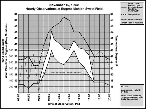
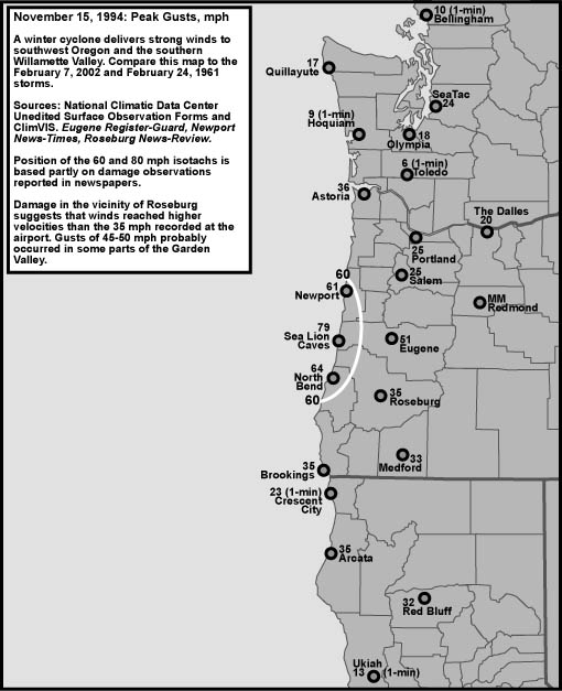
The November 15, 1994 windstorm was so localized to the south valley that, in the Oregonian, it only rated a small column in the Northwest section, page E2. For the February 7, 2002 event, this reporting pattern was more-or-less repeated, with an initial article on February 8, 2002 on page C9 in the Metro/Northwest section. Though, due to the magnitude and surprise nature of the 2002 storm, it merited a follow-up article the next day, and at least one special science article in later weeks [1]. Peak gusts, shown in Figure 16, reveal a storm significantly weaker than the event of 2002. When compared to Eugene's The Register-Guard printed the day after the 2002 SVS, the front page of the same journal for November 16, 1994 looks uncannily familiar. Alongside the headline "Wind hits the valley with gusto" is a photograph of a house that had its roof punched in by a toppled 100-foot-tall Douglas-fir [2] (used with permission © The Register-Guard). Winds, which reached 51 mph at the Eugene airport at 9:24 AM, broke trees and branches throughout the region. Among the scattered structures that were damaged, the home in the photograph was probably the most severely wrecked. Another house was struck by a maple to the tune of $50,000. A U. S. Bank building under construction on 8th and Willamette shed a flurry of sheet metal before the gale, causing the closure of the former street. A few hundred customers of the Emerald People's Utility District and Eugene Water & Electric Board had their power severed by the wind. At the Venetia-Elmira area, a transformer was simply yanked from its pole, which apparently forced a road closure. In Eugene, police directed traffic at intersections where the signal lights failed. A single injury happened when a strong gust prostrated a 96-year-old man in front of the Ya-Po-Ah Terrace retirement home. He was not severely hurt. On the coast, at the Lincoln County Courthouse in Newport, wind gusts reached 61 mph by 03:00 [3]. Commentary on the local nature of the gale during this November storm appeared in the Register-Guard [4]. "Eugene appeared to be at the center of the storm in the Willamette Valley," said a meteorologist for the National Weather Service, Eugene. Oregon's south and central coast was the only other location to be struck by high winds. Peak gusts reached 79 mph at Sea Lion Caves and 56 at North Bend [5]. Just six and-a-half years later, these same regions, save Newport, would be devastated by the archetype SVS. SVS feature one of five, high winds confined to the south valley, is met. One noticeable difference between the 1994 and 2002 scenarios is that the 1994 event was not a surprise to NWS forecasters: the Eugene-Springfield weather prognosis ran in the Register-Guard on November 15th was for southeast winds of 30 mph, gusting to 40 [6]. Not too far off the mark, especially when considering the fact that wind readings at airports are often higher than the tree-filled neighborhoods that surround them. Sustained winds of 30-45 mph with gusts to 70 had been expected on the Oregon coast, a prediction that is quite similar to the one made for the same region at 1:16 PM on February 7, 2002. There's probably a good reason why the 1994 storm was forecast so well-the cyclone that triggered these winds appears to have been broader, and was moving slower than the storm of 2002, giving meteorologists more time to make their predictions. This plodding nature will be looked at in more detail below. The article closed with the expectation of snow down to 500 feet elevation by November 17th, suggesting that cold air was being slowly pulled into the region. According to the NOAA Storm Event archives [7], the November 15th cyclone, who's effects lingered into the 16th, produced anywhere from 15 to 34 inches of snow in the Cascades. Importantly, about two inches fell on the lower foothills of western Oregon. This lowland snow "signature," of course, showed more strongly in the 2002 storm. Figure 1, below, a plot of hourly wind and temperature conditions at Eugene for November 15, 1994, was made using data obtained from the National Climatic Data Center (NCDC) [8]. The correlation between temperature and wind is striking. During the early morning, a north to northeast breeze persisted, and the temperature stayed in the mid 40s. By 07:50, wind direction had shifted to SSE, the velocity started to increase, and the temperature jumped sharply from 43° to 50° F. As the morning progressed, winds stayed SSE, reached 35-50 mph, and the temperature continued to climb. By noon, it was 59° F. Further study of the NCDC data shows that the subsequent drop to 54° correlates with some very light rainfall, at which time the winds go through a secondary peak, and then decline, along with temperature. This appears to be the mark of a weak frontal system. From 16:50 to 17:50, a fairly heavy 0.16" of rain fell, the temp dropped from 49° to 46° F, and winds shifted from ESE to NW. All the mark of low's passage right over Eugene and the arrival of a weak bent-back occlusion, and very similar to events at Eugene during the February 7, 2002. |
|
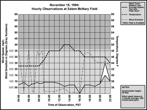
| On November 15, 1994, sunrise at Eugene was at 07:08, and sunset 16:48. The temperature rise, and wind escalation, fall neatly within that window. There is probably a level of coincidence working here, but it begs the question about how much of Eugene's strong warming was due to the solar "footprint," and how much was produced by warm air carried northward by the cyclone. In the middle of November, the sun at the latitude of Eugene is fairly low, so its influence probably wasn't as strong as it might seem. A plot of hourly data for Salem is provided in Figure 2, below, to help constrain the sun's impact on Eugene's temperature that day [9]. This plot also serves a dual purpose, as it provides a graph of conditions at a station north of the cyclone's center, demonstrating the lack of damaging winds in the north valley. |
|
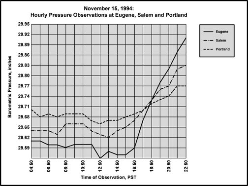
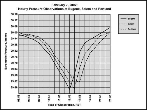
Salem was under the influence of a northerly zephyr during the entire time that Eugene was getting battered by a southerly gale, a striking contrast that places the cyclone's center south of Oregon's capitol. And Salem only managed a high of 50° F. The diurnal warmup at Salem is weak but fairly typical, and peaked at a time typical for an afternoon high, between 14:00 and 15:00. Eugene peaked at noon, somewhat early for a typical diurnal pulse. Both stations had the same minimum--43° F--and it could be surmised that Eugene, without the southerly winds, might have followed a similar climb to that seen at Salem. Sky conditions weren't drastically different at either location--lots of clouds in multiple decks, some broken. Thus, the difference in high temperatures probably reflects the additional heating from the warm air advection at Eugene: 9° F, part of which is probably due to downsloping off the southern ranges. Some of Salem's cooler temperature probably resulted from the north winds, which carried colder air southward from northern lands. Without this, Salem might have gotten warmer, which suggests that the warming benefit from the southerly winds at Eugene was probably less than what the simple calculation above suggests. In any event, owing to the sudden and high temperature rise, it seems that Eugene did benefit, at least in part, from warm air advection during the high winds. Salem's graph also shows the clear arrival of the bent-back occlusion with the onset of north-northwesterly winds after a period of calm. As with Eugene, the initial temperature fall from the afternoon high correlates with the onset of light rain. Precipitation gets heavier as the winds shift to the northwest, then west, and finally southwest, at which time the winds peak at 25 mph. The SW winds mark the time when the pressure gradient between Eugene and Salem had switched to positive, after being negative all day. The occurred when the low center passed Eugene and moved ENE into Central Oregon. Figure 3, below, is a plot of the hourly barometric pressure reading for Eugene, Salem and Portland in the NCDC data [10], which can be compared to Figure 4, below, which depicts the pressures at the same stations on February 7, 2002. Due to the larger swing of pressure in 2002, the scale of the chart had to be doubled to 0.06" per line instead of 0.03". The 1994 storm's broader, slower-moving nature is clearly shown (more on this below), with the time period of primary pressure declension off the chart to the left, and a long period of nearly flat pressures during the daylight hours. The compact and fast-moving 2002 cyclone produced sharp, inverted shark fins on the chart. Despite the dimensional differences, there's some significant barometric similarities between the two events. During the 1994 storm, Eugene shows a fairly rapid rise in barometric pressure that began with the arrival of the bent-back occlusion. Between 16:50 and 17:50, the barometer shot up 0.08"--about 1/4 the rate-of-rise seen in 2002, but still speedy. Salem's fastest rise was 0.05" an hour, and Portland's 0.03". The max rise figures for February 7, 2002 were Eugene ~0.33", Salem 0.21" and Portland 0.16" an hour [11]. For both storms, the magnitude of pressure change over a fixed time span decreased in a northward direction. This is the mark of a cyclone moving northeastward across the South-Willamette Valley and weakening. Another mark of the northeastward track is the negative gradients ahead of the low, with a sudden switch to positive as the cyclone's center moved across the valley and into the Cascades. |
|
| One pressure detail that is particularly striking about this storm in terms of agreeing with the February 2002 event is that North Bend experienced a significant pressure surge as the low center made landfall nearly on top of the station. I haven't made a graphic for this yet, so here are the numerical details from the unedited surface observation form obtained from the NCDC for November 15, 1994: |
|
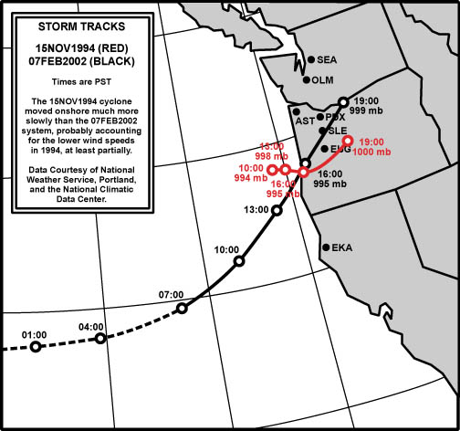
North Bend underwent a noteworthy pressure surge of 0.41" in 3 hours as winds shifted from south-southeast to west-northwest, the mark of a low center passing quite close, if not over, the station. The 0.21" in one hour is one of the fastest hourly pressure rises in the history of the station. The reading has been exceeded by the March 27, 1963 windstorm (0.22" in one hour), February 24, 1958 (0.23"), October 12, 1962 (0.26") and February 7, 2002 (0.42"). The rapid positive tendency for the 1994 storm at North Bend is in good agreement with the 2002 South Valley Surprise. It was mentioned that the wind data for Eugene and Salem put the low's center between the two stations at some point. The barometric traces, which show a low of 29.56" at Eugene, and 29.62" at Salem, suggest that the low didn't tack exactly between the two. The cyclone's center seems to have passed more closely to Eugene, maybe significantly south of Corvallis. Examination of NCDC copies of the surface observation charts for the November 15, 1994 time period, show the low moving nearly over Eugene, if but a bit south. They also show the system plodding slowly ESE offshore all day on the 15th, as depicted in Figure 5, below, which compares the two storm tracks. The 1994 storm underwent an acceleration as it dove inland, moving twice the distance of the last two time periods. This, plus some weakening, explains the sudden upswing in pressures seen in Figure 3. |
|
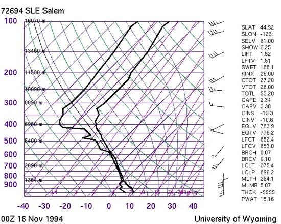
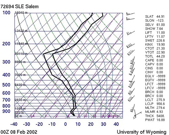
In terms of the low's track, there's an interesting bit of reporting from the Newport's News-Times [12]. At the Shilo Inn, the north end of the building had its siding stripped off. This is in sharp contrast earlier windstorms, which had peeled off the cover on the structure's south side. A change of wind direction, presumably out of the north quadrant, was cited for the difference. Even the director of Lincoln County Emergency Services commented on the unusual direction for the wind, noting the typical southerly gales for winter storms. He also said, "A lot of people who have been protected by hills or whatever in the past were surprised that they had some damage this time." This northerly direction supports the notion that the low's center tracked inland south of Newport. In seems that Newport and Lincoln City were probably hit with a fairly strong northwest surge associated with the storm's bent-back occlusion. Probably the largest difference between the two SVS events was the time span in which they occurred. If strong wind readings are defined by the hourly observations which include gust along with average wind speed, then, at Eugene, the February 2002 event lasted a brief three hours, compared to a whopping ten in November 1994. This difference was due to a slower track for the 1994 cyclone. The combination of slower speed, and weaker pressure differences most likely spared Eugene the severe blow seen in 2002, as energy wasn't as concentrated. The 2002 SVS's winds of 50 mph gusting to 70 hit with twice the force of the 1994 SVS's 35 mph gusting to 50. Before closing, it is helpful to look at the upper-air situation during the two different storms. Below are the skew-T plots for Salem, both obtained at 16:00 PST on the days of the storm (courtesy of the University of Wyoming), which happens to coincide with the time of landfall for the low centers (by coincidence, both storms wandered into Oregon's beaches at nearly the same hour). There's a striking difference between the two events. Upper-level winds, indicated on the right-hand side of the charts, were much stronger in the middle-to-upper atmosphere for the 2002 storm. Notice especially the light winds at about 7 km on during the November 1994 cyclone--winds were just 5-10 knots. During the February 2002 event, winds were 50 knots--around an order of magnitude faster! And higher up, from 11-16 km, winds were 25-40 knots for the 1994 storm, and 55-85 knots for 2002. The upper-air support for strong winds at the surface was significantly better for the later windstorm! |
Footnotes 1. On the official surface weather observation form for Roseburg, a gust to 30 knots was recorded on November 15, 1994, which converts to 35 mph. |
References [1] The articles are, "Storm takes mid-Willamette Valley by Surprise," Oregonian, February 9, 2002, Metro/Northwest section, Page E1. And "Surprise windstorm a puzzle for scientists," Oregonian, February 20, 2002, Science section, Pages C11-12. [2] Material for November 15, 1994 storm damage to Oregon's interior is from the Register-Guard, Eugene, November 16, 1994, in "Wind hits the valley with gusto," pages 1A and 4A. Oregonian, November 16, 1994, "Winds topple trees and lines in Lane County," Northwest section, Page E2. [3] Information on the November 15, 1994 storm damage to Oregon's coast, including Newport and Lincoln City, is from the News-Times, Newport, November 18, 1994, in "Wednesday morning wind storm takes swipe at county," pages A1 and A8. [4] Register-Guard, Eugene, November 16, 1994, Pages 1A and 4A. [5] Storm Event Archives, National Oceanic and Atmospheric Administration, for Oregon, November 15-17, 1994. Event title: High Wind/Heavy Snow. Data collected online. [6] Page 2A. [7] Storm Event Archives, National Oceanic and Atmospheric Administration, for Oregon, November 15-17, 1994. Event title: High Wind/Heavy Snow. Data collected online. [8] National Climatic Data Center, Unedited Surface Observation Form, for Eugene Mahlon Sweet Field, November 15, 1994. [9] National Climatic Data Center, Unedited Surface Observation Form, for Salem McNary Field, November 15, 1994. [10] National Climatic Data Center, Unedited Surface Observation Forms, for Eugene Mahlon Sweet Field, Salem McNary Field, and the Portland International Airport, November 15, 1994. [11] Eugene's figure is for a 48-minute period. Data from the National Weather Service, Portland office, collected online. [12] This information is from the News-Times, Newport, November 18, 1994, in "Wednesday morning wind storm takes swipe at county," and photo caption, bottom left, both on page A8. |
Last Modified: May 8, 2003 You can reach Wolf via e-mail by clicking here. | Back | |