The Double Windstorms of October 26-27, 1950 compiled by Wolf Read |
|
The great storms of October 26-27, 1950 were fickle with their maximum winds, striking some places sharply, and skipping past others. Some stations that did not receive a strong gale in the first storm were more severely afflicted in the second. Ultimately, however, it seems that this double-blow event was not as strong as the double-storm sequence during November 13-15, 1981. Across the region, peak gusts were generally higher in the first storm of the 1981 sequence when compared to the first event of the 1950 sequence, as indicated by an 11-station average of 65.9 mph compared to the ten-point lower average of 55.4 for the storm of October 26, 1950 [1]. The second storm moved in rapidly behind the first--peak gust times at Sea-Tac, for instance, were only twelve hours apart! This is one of the fastest second-storm arrivals among the few significant double-blow events of the 1950-to-present era. The double events of December 21-22, 1955, October 11-12, 1962 and November 13-15, 1981 ranged from 20-30 hours apart. These cyclones were generous with rainfall--in fact, too much so, producing many all-time October precipitation records over the 25th to 30th (as of the 1950 timefreame of the storms), especially in Northern California and Southwest Oregon, where daily and monthly records were shattered. The Eel and Smith Rivers in NW California flooded--this was the earliest flood on record for the Eel [2]. In Oregon, heavy flooding occurred along the Willamette at Eugene, the Coquille at Myrtle Point, the Umpqua in Douglas County, and the Rogue in the Medford-Grants Pass area. About 2,000 families had to be evacuated, and several towns were isolated for days. Total damage from these storms in Oregon amounted to about 2,000,000 in 1950 dollars [3]. California suffered about $500,000 from the wind alone, with $250,000 happening in Sacramento. Seven people were killed by the flooding and high winds. |
|
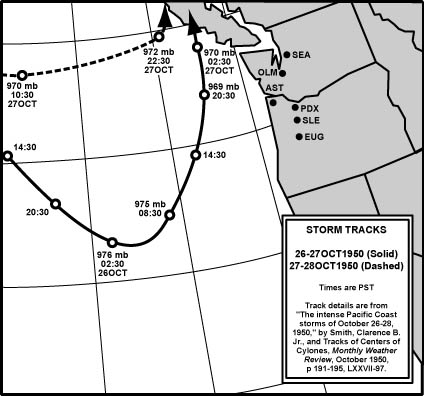
Storm Data Figure 1, below, plots the two storm paths from October 26-27, 1950. The first system's central pressure fell to 967 mb while the storm was tracking north off of Oregon, and the second 970 mb, both very low pressures for so early in the season, especially considering the region they passed through. The strong U-shaped curve of the first cyclone's trail has shown up at other times, including March 1, 1974. Source for the 1950 information: "The intense Pacific Coast storms of October 26-28, 1950," Smith, Clarence D. Jr., and "Tracks of Centers of Cyclones," Monthly Weather Review, October 1950, pp 191-195, LXXVII-97. |
|
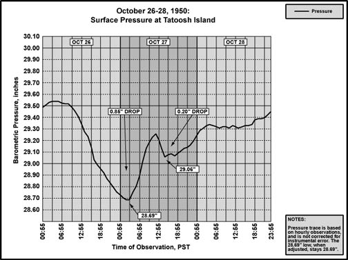
Figure 2, below, shows the 72-hour pressure trace for Tatoosh Island. With a reading of 28.69", the first storm produced one of the lowest barometric minimums in the history of Tatoosh Island, the mark of a very intense storm. The second storm had a much smaller declension, as the center did not track as close to the station. Source: hourly pressure data is from the National Climatic Data Center, unedited surface observation forms. |
|
Table 1, below, is a list of the lowest barometric pressures, and time of occurence, from the two storms. Readings in italics mark a station that had missing data at a critical time during the storm, and the values are extrapolated from nearby stations. The low readings produced by the first storm set many records as of the time period of the event. October monthly records were established for Arcata, Medford, Portland, Astoria (North Head) and Tatoosh Island. All-time record lows were established for Eugene, Salem, Olympia and Sea-Tac. However, many of these records would fall (and some fairly soon) to three later events: December 4, 1951, October 12, 1962, and December 12, 1995. For the first storm, the 11-station average minimum pressure of 28.91" is among the lowest in the 1950-to-present era. The October 26-27, 1950 value falls short of the 28.69" average produced by the December 12, 1995 windstorm, 28.85" from the Columbus Day Storm of 1962 and 28.90" from the December 4, 1951 windstorm. Source: Microfilm copies of the unedited surface observation forms, obtained from the National Climatic Data Center, and "The intense Pacific Coast storms of October 26-28, 1950," Smith, Clarence D. Jr., Monthly Weather Review, October 1950, pp 191-195. |
|
Table 1 Notes: [Overall] For storm #2, pressures in the far south, such as at Arcata and Medford, weren't changed much. The actual minimums and their timing are a bit speculative. [1] No sea level pressure data for Astoria on the surface weather observation forms for the 1950 timeframe. The data listed for Astoria is from North Head, Washington. Pressure was noted in 3-hour intervals, and the actual hourly minimums could be lower, and the timing of the minimums could be different. [2] The Portland surface weather observation forms for the time period of the storm are lost. Pressure data was obtained from the Local Climatological Data Monthly Summary, October 1950. In this publication, pressure was noted in 6-hour intervals, and the actual hourly minimums could be lower, and the timing of the minimums could be different. [3] No Quillayute data in 1950. The readings are for Tatoosh Island. |
Table 2, below, is a list of the maximum pressure gradients, and time of occurrence, for the two storms. Gradients during the first storm were quite high, right in the range for a good windstorm. None, however, are records. For the first of the October 1950 windstorms, the max gradient for the long ACV-TTI measure was 37.9 millibars (1.12") at 04:00 on the 27th, one of the steepest on record. For comparison, the 1962 Columbus Day Storm managed a peak ACV-TTI gradient of 32.3 mb (0.95") at 22:00 on the 12th, the October 21, 1934 windstorm generated an EKA-TTI gradient of 38.6 mb (1.14") at 13:00 on the 21st, the January 19, 1964 (ACV-TTI) and November 14, 1981 (ACV-UIL) windstorms produced 38.7 mb (1.14") at 16:00 on the 19th and 08:00 on the 14th respectively, and at 18:00 on December 12, 1995 (ACV-TTI) the gradient reached an incredible 39.5 mb (1.17"), the highest on record. Source: Microfilm copies of unedited surface observation forms, obtained from the National Climatic Data Center. |
|
Table 2 Notes: [1] Due to the 6-hour span between available pressure readings at PDX, gradients were extrapolated, and are probably low. Timing is probably off as well. [2] See [1]. In the case of this measure, no extrapolation was done. These are the maximum 6-hour gradients. |
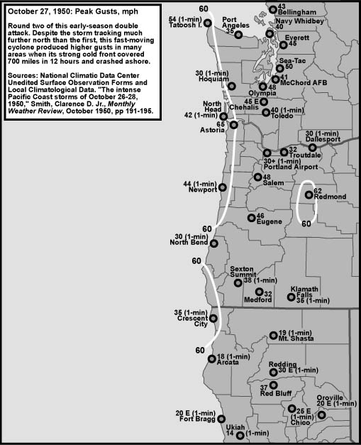
Peak Wind and Gust Table 3, below, details the peak winds for the first storm, October 26-27, 1950, at eleven key weather stations in the Pacific Northwest. "Peak Wind" is the highest observed 1-minute average, and "Peak Gust" is highest instantaneous speed (sometimes referred to as a peak 1-second gust). With an eleven-station average peak gust of 55.4 mph, this storm just makes the category of 55.0+ major events. However, compared to other storms that followed similar tracks, the October 26-27, 1950 gale ends up behind several, including December 12, 1995 with an average peak gust of 61.4 mph among the eleven stations, November 14, 1981 with 65.9, and October 12, 1962 with 80.5. Medford experienced a strong southeast gale during the early afternoon of October 26th, with 60 mph gusts. This event happened ahead of the incoming cyclone in the middle of the pressure declension phase, and during a period of light rain that appears to be associated with an incoming front. These southeasterly winds are somewhat akin to the peak east-southeast gust of 54 mph at Sea-Tac at 15:54 on October 26th in that both occurrences of strong easterly winds happened well ahead of the cyclone's closest approach, a typical feature at these locations when big storms move inside 130º west longitude. Source: All these readings are from the National Climatic Data Center, microfilm copies of the unedited surface observation forms, save Portland, which is from the Local Climatological Data monthly summary, October 1950. |
| Location | Peak |
Direction |
Obs Time of |
Peak |
Direction |
Obs Time of |
| California: | ||||||
| Arcata [1] | 40 |
SW |
21:11 HRS, 26th |
65 |
SW |
17:30 HRS, 26th |
| Oregon: | ||||||
| North Bend [2] | 31 |
WSW |
03:28 HRS, 27th |
40 |
WSW |
03:28 HRS, 27th |
| Astoria | 40 |
SW |
10:00 HRS, 27th |
60 |
SW |
10:00 HRS, 27th |
| Medford | 40 |
SE |
13:00 HRS, 26th |
60 |
SE |
12:45 HRS, 26th |
| Eugene [3] | 25 |
SW |
03:03 HRS, 27th |
45 |
SW |
03:03 HRS, 27th |
| Salem | 31 |
SSE |
01:28 HRS, 27th |
47 |
SSE |
01:28 HRS, 27th |
| Portland [4] | 50 |
SW |
MM, 27th |
66 |
SW |
MM, 27th |
| Washington: | ||||||
| Tatoosh I. [5] | 52 |
E |
16:23 HRS, 26th |
68 |
E |
16:23 HRS, 26th |
| Olympia [6] | 20 |
SSE |
05:28 HRS, 27th |
34 |
SSE |
01:05 HRS, 27th |
| Sea-Tac [7] | 40 |
SW |
08:38 HRS, 27th |
65 |
SSW |
07:53 HRS, 27th |
| Bellingham | 38 |
SSW |
09:09 HRS, 27th |
59 |
SSE |
08:50 HRS, 27th |
| AVERAGE | 37.0 |
SSW |
55.4 |
S |
Table 3 Notes: [1] Peak wind of 40 mph at Arcata is the last of two occurrences, the other having occurred at 17:30. [2] Gust not recorded at North Bend in 1950. Peak gust was extrapolated from the peak wind using a standard 1.3 gust factor. [3] Peak wind of 25 mph at Eugene is the last of four occurrences. [4] Surface observation forms lost for Portland during the 1950 timeframe. Peak wind of 50 mph is a fastest mile reading obtained from the Local Climatological Data monthly summary, Portland, October 1950. Peak gust of 66 mph also obtained from LCD. Direction of peak gust extrapolated from direction of fastest mile. Times were not noted in the publication. It is assumed that the peak wind and gust listed in the LCD occurred during the first cyclone, and not the second storm, which occurred later in the day. This assumtion is based on the fact that the first storm followed a path that was much more favorable for a high-wind-warning criteria event at Portland. And, at Troutdale, the closest official station to the Portland Airport, the winds from the first storm were clearly stronger than those from the second. [5] Gust not recorded at Tatoosh Island in 1950. Peak gust was extrapolated from the peak wind using a standard 1.3 gust factor. After the low had passed north and winds had shifted southerly during a brief period with a light breeze, the wind suddenly escalatd again, peaking at 49 mph out of the southwest at 09:25 on the 27th. [6] Peak wind of 20 mph at Olympia is the last of two occurrences, the being at 02:28. [7] Peak wind of 40 mph at Sea-Tac is the last of two occurrences, the other being at 07:55. Very strong east winds set up ahead of this storm, with a peak gust of 54 mph out of the ESE at 15:54 on October 26th. |
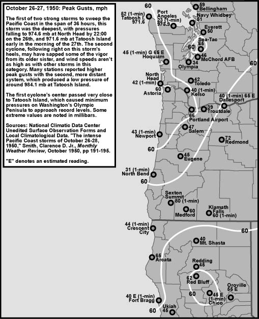
Table 4, below, details the peak winds for the second storm, which stuck late on October 27, 1950, at eleven key weather stations in the Pacific Northwest. This storm was generally weaker throughout the area of its effect, with notable exceptons being Astoria, Tatoosh Island, and Olympia. The eleven-station average peak gust of 45.7 mph puts this storm at the low end of the "moderate" category. The more northern track of this cyclone compared to the first event likely contributed to the lower average--wind speeds in the southern sector just didn't get that strong, for the storm was quite distant from these locations. However, places far north and close to the action, like Sea-Tac and Bellingham, simply weren't as affected by the second storm at the same magnitude of the first. Source: All these readings are from the National Climatic Data Center, microfilm copies of the unedited surface observation forms, save Portland, which is from the Local Climatological Data monthly summary, October 1950. |
| Location | Peak |
Direction |
Obs Time of |
Peak |
Direction |
Obs Time of |
| California: | ||||||
| Arcata [1] | 18 |
SE |
17:30 HRS, 27th |
23 |
SE |
17:30 HRS, 27th |
| Oregon: | ||||||
| North Bend [2] | 30 |
SW |
17:28 HRS, 27th |
39 |
SW |
17:28 HRS, 27th |
| Astoria | 45 |
SW |
15:00 HRS, 27th |
65 |
SW |
15:00 HRS, 27th |
| Medford [3] | 23 |
S |
14:00 HRS, 27th |
32 |
S |
14:00 HRS, 27th |
| Eugene | 33 |
S |
15:05 HRS, 27th |
46 |
S |
15:58 HRS, 27th |
| Salem | 38 |
S |
14:28 HRS, 27th |
48 |
S |
14:28 HRS, 27th |
| Portland [4] | 30 |
SSW |
16:00 HRS, 27th |
39 |
SSW |
16:00 HRS, 27th |
| Washington: | ||||||
| Tatoosh I. [5] | 54 |
SSW |
22:24 HRS, 27th |
70 |
SSW |
22:24 HRS, 27th |
| Olympia | 30 |
SSE |
14:28 HRS, 27th |
48 |
S |
16:03 HRS, 27th |
| Sea-Tac | 35 |
S |
17:25 HRS, 27th |
50 |
S |
17:25 HRS, 27th |
| Bellingham | 27 |
SE |
14:58 HRS, 27th |
43 |
SE |
14:58 HRS, 27th |
| AVERAGE | 33.0 |
S |
45.7 |
S |
Table 4 Notes: [1] Peak wind of 18 mph at Arcata is the last of four occurrences. Wind was too low for gust to be noted, and a peak gust was extrapolated from the peak wind using a standard 1.3 gust factor. [2] Peak wind of 23 mph at Medford is the last of two occurrences, the other having occurred at 12:29. [3] Gust not recorded at North Bend in 1950. Peak gust was extrapolated from the peak wind using a standard 1.3 gust factor. Peak wind of 30 mph last of two occurrences, the other having occurred at 16:28. [4] Surface observation forms lost for Portland during the 1950 timeframe. Peak wind of 30 mph was taken from the six-hourly observations printed in the Local Climatological Data monthly summary, Portland, October 1950. Peak gust not noted, and extrapolated from the 30 mph peak wind using a standard 1.3 gust factor. The peak wind and gust values are likely lower than what actually occurred. [5] Gust not recorded at Tatoosh Island in 1950. Peak gust was extrapolated from the peak wind using a standard 1.3 gust factor. |
Heavy Rainfall October 25-30, 1950 Figure 3, below, shows rainfall totals for the October 25-30, 1950 timeframe. Many places in Southwest Oregon and Northern California set 24-hour and monthly records. With 5.09", Bend, Oregon, normally shielded by the Cascade Mountains, had more rainfall than typically wet Portland and Salem, which had 2.38" and 4.17" respectively. Bend's total for the month of October, 5.88", is a record that still stands today. Other record October from 1950 that still stand include: Medford 9.16", Roseburg 12.53", and Brookings 21.93". In California, at least 34 stations established new monthly records during October 1950. This includes Eureka, which had 13.04", a record that stands today. This record is also 4.5" higher than the next wettest October for Eureka, and, a record 5.83" of that 13.04" fell in 24-hours, an all-time extreme that survived for 52 years, until 6.79" of rain fell in a single day during a minor windstorm on December 27, 2002. Gasquet had 26.10" of rain during October 1950, and Upper Mattole 25.62". Source: Western Regional Climate Center, Climatological Data Summaries (LCD), and "The intense Pacific Coast storms of October 26-28, 1950," Smith, Clarence D. Jr., Monthly Weather Review, October 1950, pp 191-195. |
|
References [1] Peak gust data is from the National Climatic Data Center, unedited surface observation forms (SWO), for Eureka/Arcata, Medford, North Bend, Eugene, Salem, Portland, Astoria, Olympia, Sea-Tac, Quillayute, Tatoosh Island and Bellingham, October 26-28, 1950. [2] The brief summary of storm damage is from "The intense Pacific Coast storms of October 26-28, 1950," Smith, Clarence D. Jr., Monthly Weather Review, October 1950, pp 191-195. See especially the first two paragraphs of page 191. [3] Cost of storm damage is from "The intense Pacific Coast storms of October 26-28, 1950," Smith, Clarence D. Jr., Monthly Weather Review, October 1950, pp 191-195. See especially the first two paragraphs of page 191. |
Last Modified: May 30, 2003 You can reach Wolf via e-mail by clicking here. | Back | |