The Powerful October 2, 1967 Storm King "Jr." compiled by Wolf Read |
|
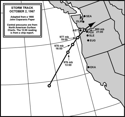
Introduction In early October 1967, an unusual event struck the Pacific Northwest: a deep low spun up far off of Northern California, then moved at fairly steady speed in a northeast direction, and landed on the north Oregon coast. As the storm moved into the Washington Cascades, south winds gusted 60 to 80 mph across the Willamette Valley, and caused the most damage since October 1962 for many places therein. Strong cyclones aren't unusual in the east Pacific during the winter, and they're fairly common in Alaskan waters in autumn. To have such a strong low develop so far south in the first days of October is a bit rare, though not entirely unprecedented. Big cyclones can start up near Northwest shores in August, and fairly powerful September tempests have pummeled the region on occasion, such as on September 7, 1951, when winds gusted up to 54 mph at the Seattle Naval Air Station. But not commonly. Not until the end of October, and more typically as late as early November, do the big sou'westers start making more regular appearances in Northwest climate history. But, like the pop artists of the day, cyclones during the 1960s didn't seem interested in being typical: they went for the outrageous. The Columbus Day storm of 1962 was also an early October windstorm. The March 27, 1963 event happened late in the season. With two major early-October gales, and one large springtime tempest, all in the narrow span of five years, it seemed to some Northwesterners that the weather had possibly gone haywire. Quite interestingly, a major windstorm swept through Northern California and Oregon on October 2, 1882, an event that is being studied currently, for it may have followed a similar path to its 1967 cousin. The early-season timing of the October 2, 1967 event contributed to a distinctive, but not unique, feature: thunderstorms. The sun's rays are still fairly strong in early autumn, certainly when compared to the dark winter months. This additional thermal energy appears to have helped convection before, during, and after the storm. Thunderstorms in various forms, and associated with different storm structures, struck nearly every Weather Bureau reporting station in the October 1st to 3rd timeframe, or at least passed close enough for lightning to be seen. The diurnal solar-thermal pulse was just one reason for the widespread development of cumulonimbus clouds. A large area of cold air aloft was pulled over the Northwest behind the low. A cold atmosphere high up is an unstable situation, and on October 3rd, it made for a literally explosive breeding ground for thunderstorms. This region of cold air, in association with the wind speed and direction signatures for stations in western Oregon, supports the placement of the October 1967 event in the same class as the January 1880 Storm King. The 1967 "Storm King Jr." didn't depress temperatures at the surface very much--there simply wasn't much cool air to be had so early in the season. As noted in the 1880 Storm King webpage, one distinctive aspect of the 1880 storm was the arrival of snow with the westerly flow behind the cyclone. Lowland snow did not happen anywhere during the 1967 storm, not even north of the low's track, where the coldest air would tend to reside. However, the cool air aloft that spread over the entire northwest on October 2nd and 3rd had that Storm King taint. In 1880, such an upper-level cold pool probably followed the main event. The unstable air may have been mixed down to the surface after the Great Gale, and contributed to the snowy problems. During the 1967 storm, it's fairly clear that very cold air didn't make it to the surface, not even during the heavier thunderstorms--but frozen precipitation did, of a unique variety. Hail. Large, damaging stones. And a tornado. These incidents will be examined more closely later in the discussion. For the Willamette Valley, the October 2, 1967 windstorm was probably the third most powerful event to strike during the 1950-to-present era--just barely behind the March 27, 1963 storm that followed a similar path, and, of course, largely behind the Columbus Day Storm. This, too, is examined in more detail further down this page. Interestingly, another strong event followed a similar track to the March 1963 and October 1967 events, this in February 1965. The 1965 storm produced a strong gale in the Willamette Valley, with gusts as high as 81 mph at Troutdale. With big Willamette Valley wind events triggered by cyclones following similar paths in the years 1963, 1965 and 1967, one is tempted to think that some kind of semi-permanent pattern had set up right after the Columbus Day Storm, and continued for at least a half decade. This may have been the case, but it would be hard to prove. And the pattern, if it was there, may have been in place for longer than five years. The storm on March 1, 1974 was of similar track-type to October 2,1967 and its close cousins. Detailed surveys of surface maps show some other lesser events in the period 1970-1975 as well. This could have been a Pacific Decadal Oscillation (PDO)-related pattern, one that may have shifted duirng the big 1976-77 transition from a cold-wet phase to a warm-dry one. The change appears to have reduced (but not eliminated) the frequency of lows following a landfall path between Newport and Astoria. However, this does not explain why such tracks appear rare in the late 1940s and through the 1950s, which also includes the PDO cold phase--1947-1976 are the accepted years among climatologists for the particular cold episode in question. It is possible that the Columbus Day Storm may have occurred during the transition phase of a climate oscillation that hasn't been identified yet. The October 2, 1967 windstorm made landfall as a 977 mb system. The Inauguration Day storm of 1993, which visited much destruction upon Western Washington, landed as a 976 mb storm. Here we have the results of two cyclones with similar intensities, but with tracks separated by about 150 miles in a north-south direction. Since most of Western Washington was spared destructive winds in 1967, one might look at the Inauguration Day storm as Washington's answer to the October 2, 1967 event. Readers are encouraged to visit the 1993 storm's web page for comparison to the 1967 event. In terms of peak wind speeds, the results were quite similar, but shifted north by about 150 miles for the 1993 gale. The March 26, 1971 storm also had a 978 mb central pressure as it raced northward off the Washington Coastline and landed on the tip of the Olympic Peninsula. Figure 1, below, details the October 2, 1967 storm's track, with central pressures and times noted. |
|
General Storm Data Minimum Pressures and Peak Gradients Table 1, below, is a list of the lowest barometric pressures, and time of occurence, for the October 2, 1967 windstorm. Though these readings are quite low for October, they aren't even monthly records, mainly due to the extreme pressures of the Columbus Day Storm just five years before. Portland and Salem had lower minima than Astoria, the mark of a low center passing very close to the Willamette Valley stations, while moving inland south of the Sunset Empire. Source: Microfilm copies of the unedited surface observation forms, obtained from the National Climatic Data Center. |
|
Table 2, below, is a list of the maximum pressure gradients, and time of occurrence, for the October 2, 1967 windstorm. With some exceptions, these gradients are strong, and a few are extreme. The EUG-PDX measure of +13.7 mb (+0.40") is the second steepest known for the time period 1948-2002--the December 4, 1951 windstorm holds this title with +15.2 mb (+0.45"). The PDX-SEA gradient of -7.4 mb (-0.22") is among the steepest negative gradients for the measure, but is not quite a record. The Columbus Day Storm produced a -7.8 mb (-0.23") PDX-SEA gradient at 14:00 on October 12, 1962. Close events include November 13-14, 1981 -6.5 mb (-0.19") at 17:00 on the 13th, and January 10-11, 1988 -6.0 mb (-0.18") at 03:00 on the 11th. The Columbus Day Storm also exceeded the October 2, 1967 AST-UIL gradient -6.0 mb (-0.18") with a reading of -9.2 mb (-0.27") at 14:00 on October 12th. A peak +13.7 mb EUG-PDX gradient and a maximum -7.4 mb PDX-SEA measure at 21:00 hours marks a very intense low, and nearly pinpoints the time that the cyclone's center passed just north of Portland. Many landfalling lows don't produce such extreme negative gradients north of their track centerline--often, it seems that landfalling cyclones dive inland at the base of a long trough of low pressure, which flattens out the pressure differentials north of the low. This happened to a lesser degree on October 2, 1967, and steep northerly gradients resulted. North winds set up in the region between Portland and Seattle in the 21:00 timeframe, but never got very strong, reaching 10-15 mph at times. The upper air support for north winds just wasn't there, as is usually the case. As an example of just what good upper air support can mean, storms with positive gradients of 7.0 to 8.0 mb for the PDX-SEA measure have generated south wind gusts of 40 to 50 mph, including the January 19, 1964 and February 13, 1979 events. Source: Microfilm copies of the unedited surface observation forms, obtained from the National Climatic Data Center. |
|
Table 2 Notes: [1] Max positive gradient was +4.0 mb at 13:00 on October 3rd. [2] Max negative gradient was -9.5 mb at 11:00 on October 2nd. [3] Max positive gradient was +5.5 mb at 01:00 on October 3rd. [4] Max negative gradient was -2.9 mb at 20:00 on October 2nd. [5] Max positive gradient was +2.6 mb at 00:00 on October 3rd. |
Pressure Tendencies The October 2, 1967 windstorm brought with it a significant "pressure couplet" over much of Western Oregon, with strong pressure surges (+3.0 mb and higher) at stations that fell within about 200 miles of the storm's center. Table 3, below, shows the maximum hourly changes in pressure for eleven key stations in the Pacific Northwest. The Willamette Valley and Oregon Coast witnessed especially strong pressure climbs with this event. Salem's peak 3-hour tendency was +13.3 mb (+0.39") from 20:00 to 23:00, and Portland's was +14.1 mb (+0.41") from 21:00 to 00:00. Despite the strength of some of the readings in Table 3, none are records. There's generally a good correlation between maximum winds and maximum pressure tendencies with this storm, save maybe Astoria, which had an active barometer without signficant winds because the low center passed south of the station. Source: Microfilm copies of the unedited surface observation forms, obtained from the National Climatic Data Center. |
| ||||||||||||||||||||||||||||||||||||||||||||||||||||||||||||||||||||||||||||||||||||||||||
Table 3 Notes: [1] The -2.9 mb hourly fall at Portland is the last of two occurrences, the other instance having occurred at 11:00. The +5.2 mb hourly rise is the last of two occurrences, the other instance having occurred the hour before. [2] The +3.1 mb hourly rise at Olympia is the last of two occurrences, the other instance having occurred the hour before. |
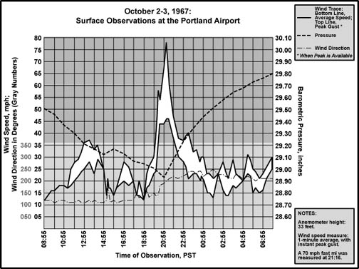
Peak Wind and Gust Table 4, below, lists the peak wind and gust for eleven key stations in the Pacific Northwest, their direction, and their time of occurrence. "Peak Wind" is a 1-minute average, and "Peak Gust" is an instant (approximately 1-second) average. By my own personal methodology, a wind event rates the term "windstorm" when the average peak gust of these eleven stations reaches 39.0 mph (gale force) or higher. The October 2, 1967 windstorm ranked as a moderate windstorm. Moderate windstorms have an average of 45.0 to 54.9, and major windstorms are those that reach or exceed 55.0. Only a handfull of storms have made the majors, including December 12, 1995, November 14, 1981 and October 12, 1962. This ranking favors those cyclones that follow a northward path close to the U.S. Pacific Coast, and for good reason--such storms affect the largest land area, and therefore are potentially the most destructive. The October 2, 1967 cyclone's eastward path near the Columbia River spared much of Western Washington a severe blow, and the storm didn't hit southern places like Arcata and Medford very hard, all features that lowered the rank of this intense storm. For select regions, such as the Willamette Valley and Oregon's south and central coast, the storm struck particularly hard, and was an event to remember. Source: National Climatic Data Center, undedited surface observation forms. |
| Location | Peak |
Direction |
Obs Time of |
Peak |
Direction |
Obs Time of |
| California: | ||||||
| Arcata | 23 |
220º |
14:58 HRS, 2nd |
37 |
140º |
08:55 HRS, 2nd |
| Oregon: | ||||||
| North Bend | 35 |
160º |
14:55 HRS, 2nd |
71 |
170º |
14:25 HRS, 2nd |
| Astoria [1] | 26 |
210º |
10:57 HRS, 2nd |
45 |
190º |
12:02 HRS, 3rd |
| Medford | 30 |
190º |
16:58 HRS, 2nd |
41 |
190º |
16:58 HRS, 2nd |
| Eugene | 41 |
180º |
18:58 HRS, 2nd |
58 |
180º |
18:09 HRS, 2nd |
| Salem | 48 |
170º |
19:45 HRS, 2nd |
68 |
170º |
19:45 HRS, 2nd |
| Portland [2] | 46 |
210º |
21:25 HRS, 2nd |
78 |
210º |
21:15 HRS, 2nd |
| Washington: | ||||||
| Quillayute [3] | 15 |
040º |
15:57 HRS, 2nd |
26 |
040º |
15:15 HRS, 2nd |
| Olympia [4] | 21 |
190º |
10:55 HRS, 3rd |
27 |
190º |
10:55 HRS, 3rd |
| Sea-Tac | 21 |
210º |
07:25 HRS, 3rd |
32 |
210º |
07:25 HRS, 3rd |
| Bellingham | 21 |
170º |
08:49 HRS, 3rd |
26 |
030º |
12:58 HRS, 2nd |
| AVERAGE | 29.7 |
177º |
46.3 |
156º |
Table 4 Notes: [1] Peak gust occurred during a post-low thunderstorm that dropped 0.6"-1.0" hail in the Astoria area and produced a tornado. This gust is considered part of the storm as it occurred in the pressure climbout phase. During the high wind period in the Willamette Valley, from about 16:00 to 23:00, Astoria's strongest gust was 32 mph out of 060º at 19:56 HRS. The direction of the 45 mph thundergust is extrapolated from the closest wind report on WBAN form A for October 3, 1967 (12:08) [2] Direction of peak gust at Portland extrapolated from direction of peak wind. Simply noted a south on WBAN Form B. [3] Peak gust at Quillayute is estimated from a peak fastest mile of 20 mph using a standard 1.3 gust factor. Direction of fastest mile stated as northeast, and 040º extrapolated from this information and direction of peak 1-minute wind. [4] Peak gust at Olympia is estimated from peak wind using a standard 1.3 gust factor. |
October 2, 1967 Third Strongest Willamette Valley Gale Since 1950? Table 5, below, compares the maximum winds measured at Eugene, Salem and Portland for the strongest storms of the 1950-to-present era and ranks them according to the 3-station average. Due to high variability around the means, this is a rough ranking. Only the Columbus Day Storm stands out significantly among the storms on this list. Of the other nine, the next four (ranks 2 to 5) are so close in their averages that they are essentially the same in strength--their averages cluster around 67.0. These can be considered the standard major windstorm for the Willamette Valley, with peak gusts generally falling between 60 and 80 mph at stations throughout the region. The return frequency for these big events is about once every ten years--in essence they represent the "storm of the decade." It is interesting, but perhaps not significant, that three storm-of-the-decade events happened in the 5-year span from 1962 to 1967. The final five storms (ranks 6 to 10) are also too close in their averages to be certain about their exact rankings--their averages cluster around 60.7. Eleven and twelve (04DEC1951 and 26MAR1971 respectively) have ranks in the range of 59, and can probably be grouped with these low 60s events. These storms can be consdered the standard strong windstorm for the Willamette Valley, with peak gusts generally ranging from 50 to 65 mph. They have a return period of about every 7 years. Note that there have been at least 21 events with a rank of 50.0 and above since 1950. As of 2003, that's an average return period of about once every 2.5 years for windstorms of moderate strength and higher. The Columbus Day Storm's significantly higher rank--35.0 points above the next strongest storm--is an indicator of a truly unique windstorm. There have been no other events like the 1962 storm in the 1950-to-present era, despite the fact that many big cyclones tend to produce peak gusts that cluster around specific ranges, like 67 and 61 mph. This is one of the reasons why I maintain that the Big Blow of 1962 should be put in its own category, especially when trying to determine peak gust potential from a new incoming cyclone. |
Top Ten Willamette Valley Windstorms since 1950 (3-Station Ranking) | |||||
Rank |
Date of Storm |
Peak Gust |
Peak Gust |
Peak Gust |
Average |
1 |
12OCT1962 |
86 |
90 |
104 |
93.3 |
2 |
27MAR1963 |
75 |
68 |
62 |
68.3 |
3 |
02OCT1967 |
58 |
68 |
78 |
68.0 |
4 |
14NOV1981 |
58 |
71 |
71 |
66.7 |
5 |
07JAN1961 |
81 |
60 |
55 |
65.3 |
6 |
01MAR1974 |
60 |
61 |
64 |
61.7 |
7 |
12DEC1995 |
49 |
59 |
74 |
60.7 |
8 |
07JAN1990 |
58 |
61 |
63 |
60.7 |
9 |
24FEB1958 |
62 |
58 |
61 |
60.3 |
10 |
22DEC1955 |
63 |
56 |
62 |
60.3 |
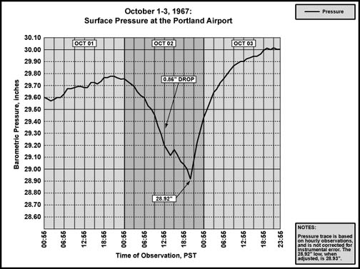
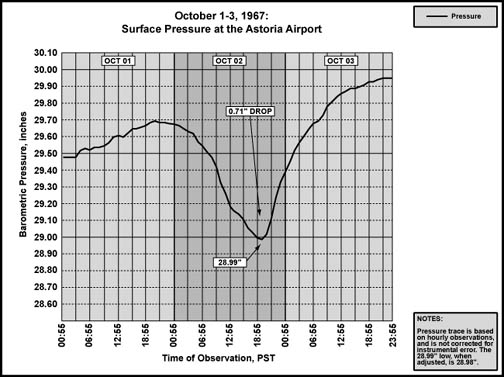
Storm Data Discussion Tables 1 through 5 show a number of very striking features for the October 2, 1967 windstorm. There is a concentration of high winds in the Willamette Valley, with gusts up to very damaging levels from Salem to Portland. Astoria, which typically shows zippy readings during winter storms, has a peak gust much lower than the valley stations. The maximum of 45 mph was kicked up by a tornado-spawning thunderstorm in the unstable environment behind the low. During the high wind period in the valley, from about 16:00 to 23:00 LST, Astoria's strongest gust was a mere 32 mph out of the northeast. Portland experienced the lowest pressure on October 2nd--even lower than Astoria, which, during the big storms, typically has some of the most depressed readings in the region. This is a clear indication that the cyclone's center passed closer to Portland. Figures 2 and 3, below, 72-hour pressure traces for Portland and Astoria, also reveal this fact. Portland's trendline is sharper, which more pointy features [1]. Astoria's is smoother, more curvy, the mark of a barometer that is further away from the steepest gradients of the storm. |
|
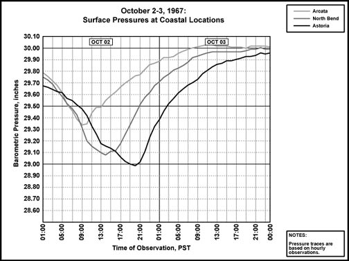
The gradients are a major feature of the 1967 event. The +13.7 mb (+0.40") difference between Eugene and Portland is the highest ever achieved for the region out of the storms examined in this book, where pressure data is available. Not even the Columbus Day Storm, which produced a peak of +9.6 mb (+0.28") in the hourly data, reached the extreme seen in 1967. A gradient of +13.2 mb (+0.39") between Portland and Olympia during the November 3, 1958 storm, which produced a +9.8 mb (+0.29") EUG-PDX slope, is probably the closest match for any interior section. As described on the Pressure Gradients page, the big windstorms tend to push the EUG-PDX gradient into the +9.0 to +10.0 mb (+0.27" to +0.30") range. This is the "sweet spot" for powerful winds in the valley. On October 2, 1967, the sweet spot was exceeded by a large margin. It's a wonder that the winds weren't stronger! Some of the other measures of gradient are also very high. The MDF-PDX value of +25.2 mb (+0.74") beats the Columbus Day Storm's maximum of +19.1 mb (+0.56") by a large margin. The closest event appears to be the Decembr 4, 1951 windstorm with a peak MDF-PDX gradient of +21.2 mb (+0.63"). The ACV-AST reading of +26.1 mb (+0.77"), which occurred at 20:00 on October 2, 1967, is no slouch. And the value for Arcata to Portland, a slighlty canted measure, reached a whopping +28.5 mb, (+0.84") at 21:00--this is nearly five millibars steeper than the strongest ACV-PDX reading during the Columbus Day Storm (+23.7 mb/+0.70"). Figure 4, below, tracks the storm's progress among three California and Oregon coastal stations in what I term a "pressure spectrum." The strong difference in the timing of the pressure minimums marks a cyclone with a signficiant northward component to its motion up to the time it made landfall south of Astoria. The minimum pressure at Quillayute (not shown) arrived at about the same time as Astoria an indicator that the low had aquired and increasing easteard component as it made landfall. |
|
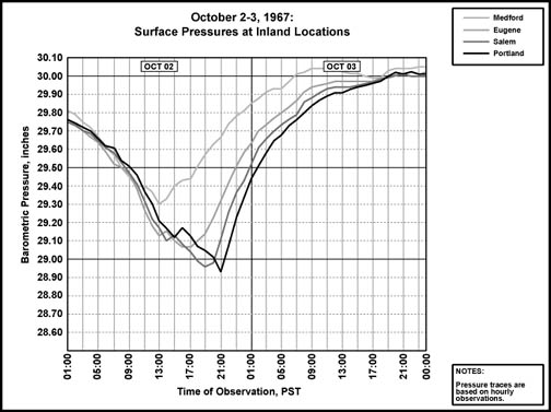
| Figure 5, below, is a pressure spectrum for four stations in Oregon's western Interior. A deepening, and steepening of the traces is evident in a northward direction, marking station proximity to the cyclone's center. The further north, the closer the station was to the core as the low trekked eastward into the South Cascades of Washington. A strong double-dip feature is evident at Willamette Valley stations. More on this below. |
|
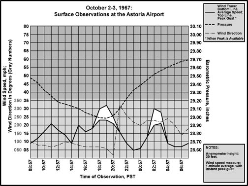
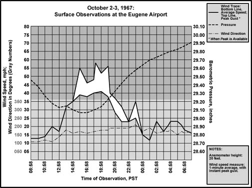
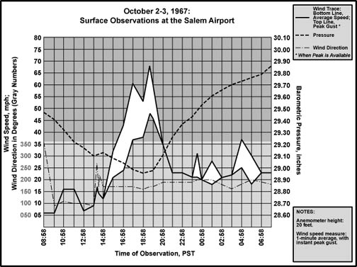
| The meteograms for Astoria, Eugene, Portland and Salem, Figures 6 through 9, below, show a number of intriguing properties, some of which bear strong similarity to the Storm King. However, the brief jump in barometeric pressures ahead of station minimums in the Willamette Valley--quite visible in Portland's 72-hour pressure trace in Figure 2, above, and in the pressure specturm in Figure 4, above--is a striking feature that was not evident in the pressure data for Portland on January 9, 1880. The double-dip feature for the October 2, 1967 storm will be examined first. This "double-dip" signature also appeared strongly during the Columbus Day Storm, and more weakly for some other events. The strength of the double dip in 1967, like 1962, warrants the close examination. |
|
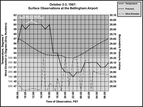
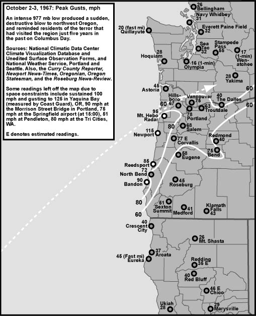
Moving from south to north in the valley, the brief barometric jump during the afternoon contrasts sharply against rapid pressure drops before, and again after, the sudden climb event. This feature shows up at Eugene around 14:00 LST, and amounts to a 0.02" rise in the hourly data. At Salem, the bound happened about an hour later, and is stronger, at 0.03". And, at Portland, the pressure jumped 0.05" during the 15:00-16:00 hour. The feature is missing at Astoria, though the slowdown in the rate of pressure fall between 13:00 and 15:00 might be considered a weak manifestation of the event. Weather conditions changed drastically during the hour that had the brief barometric jumps, especially at Salem and Portland. At Salem, the wind direction shifted from east at 9 mph, to west at 17 mph within a period of 21 minutes after the 13:58 observation. That's a striking change in direction. The same special report that noted the wind shift, which was at 14:19 LST, also noted a rapidly rising pressure, and that a thunderstorm with light rain was in progress. Just six minutes later, another special report was recorded: Winds had shifted to a little east of south and reduced to 15 mph, and a thunderstorm was right overhead, moving northeast. Heavy rain bathed the grounds and runway. At 14:30, the cloudburst had slackened considerably, and the wind had shifted to the southwest at 14 mph. The thunderstorm was now northeast of the station, still heading in a northeast direction. By the regular 14:58 report, the wind was again southerly at about 12 mph and precipitation had ceased. A whopping 0.26" of rain had fallen in the last hour (presumably, most of this within the 11 minutes from 14:19 to 14:30), and the temperature had dropped from 61° F at 13:58 to 55°. Clearly a front had passed, one that had enough instability to produce a line of thunderstorms. Within an hour of the 14:58 report, the barometer had resumed its fast plummet. Southerly winds escalated, and had reached 21 mph gusting to 32. The main wind event was almost upon Salem. We'll get back to this shortly. At Portland, a situation similar to Salem unfolded, but almost exactly an hour later--with about 49 straight-line miles between the two airports, a northward migration of 45-50 mph can be inferred. At 15:15 LST, winds at Portland were east-southeast at 14 knots, and a thunderstorm was overhead, moving northeast. A shroud of rain reduced visibility to the west, and a light precipitation tapped around the station. By 15:21, a special report noted that winds had shifted to the south, and had increased to a steady 21 mph, with occasional lightning in the clouds right overhead. The light shower continued. Just three minutes later, the rain had become a cascade, with the winds going southeast at 17 mph. Clouds had lowered to 500 feet. Brilliant flashes of electricity continued above. By 15:33, the breeze was back out of the east-southeast, continuing at 17 mph, and the thunderstorm had moved to the north-northeast, with visibility to the east now reduced. A moderate rain persisted at the airport, and the pressure was now rising rapidly. The regular report at 15:51 showed that the temperature had dropped from 59° F at 14:56 to 55° at the observation time, the wind continued east-southeast at 14 mph, and the rain had stopped, with 0.15" accumulated in the gauge during the last hour. There were breaks in the overcast. The front had moved on, and, as the pressure resumed its plunge, winds would gradually build toward a gale over the next four hours. Clearly, the barometric jumps were due to the passage of a cold front. Lower pressure tends to be favored along a storm's frontal line because it is where the strongest convection usually takes place. This distorts the tendency toward a perfectly circular isobaric structure around the cyclone. Note the tear-drop shape of the isobars in the illustration on jumping-the-gradient (ageostrophic flow) on the Pressure Gradients page, and that the points of the tear-drops are along a frontal boundary. What the pressure climbs on October 2, 1967 indicate is that, ahead of the front, the pressure fell at a rate above the basic fall that would have been produced by a perfectly symmetrical low, and the post-frontal jump was a kind of correction, putting the barometers on track with the rest of the cyclone's form. The damaging winds in the Willamette Valley during the 1967 cyclone show an interesting pattern. By counting the number of hours where the average wind was about 35 mph or more, a trend emerges. Eugene had six hours of strong wind, with a peak of 58 mph. Salem had four hours of strong wind, with a peak of 68 mph. And Portland barely managed two hours of strong wind, but the peak was a whopping 78 mph. In a line up the valley, the wind energy became more concentrated temporally, with correspondingly stronger peak velocities--the increase in peak wind force was by a factor of about 1.35 for each northward jump in location. A large part of the variance in duration probably has to do with the orientation of the pressure gradients. The further from the storm's center a station, the longer the time period it was subjected to the angle of gradient necessary for strong winds, because the pressure fields have and increasingly broader curve with distance from the center of the low. Since the distant "peripheral" stations were also in the relatively weaker gradient outside the storm's core, the winds weren't as strong. The maximum +13.7 mb (+0.40") gradient between Eugene and Portland averages to 0.13 mb (0.004") per mile. This gradient was fairly even across the valley, as indicated by the +6.2 mb (+0.18") SLE-PDX, and +7.5 mb (+0.22") EUG-SLE gradients at the same time (21:00 PST). However, note Eugene's weaker positive pressure tendency when compared to Salem and Portland. Judging from the timing of the initial south winds at Eugene and Salem, and comparing that to the estimated position of the low center along its track at those onset periods, it seems that the initial angle for strong winds was when the isobars fell canted beyond 45º of the valley's long axis. This also explains a southeasterly trend in wind direction at the beginning, which then shifted south as the low passed to the north. There appears to be another phenomenon that helped shorten the period of high winds in the Portland area. At Salem and Eugene, southerly winds began a climb to damaging levels right behind the barometric jumps that marked the frontal passage. This did not happen at Portland. After briefly flirting with a southerly direction during the line of thundershowers, Portland's winds resumed an east-southeasterly direction, and held relatively flat, but gusty, up until the last hour of the low's closest approach. There's a slow trend toward a south direction during the four-hour span between frontal passage and the onset of the stronger winds. The Columbia River Gorge is probably the main reason for the delay in strong winds. With the low more-or-less off to the west that afternoon, the gradient had a strong easterly component when the front moved through the valley. The Columbia River Gorge is a vast open channel through the mountains along a nearly perfect axis for easterly winds. The strong flow down the Columbia initiated by the easterly pressure gradient appears to have overpowered the southerly winds that were escalating further down the valley. In essence, Salem and Eugene were sheltered from significant influence from these dry, gusty winds by the Cascade Mountains. The easterly cap on the south winds at Portland probably lasted until the low had reached a point northwestward where the pressure gradient had a more southerly orientation. At that time, with the east winds decreasing due to the lack of an ideal gradient, the flood gates were opened and the southerly gale leaped into the Portland area. Another facet of this cyclone probably contributed to the "late" onset of winds in Portland. The front seems to have run ahead of the low. The cyclone's center was moving at about 25-30 mph at best estimate. As shown above, the front raced through the valley at about 45-50 mph relative to stations on a north-south axis, outpacing the parent low almost by a factor of two. The low was moving northeast, which further reduces the north vector of motion for the low center, making the difference in northward velocity even stronger. A clear indication of this disparity in motion is that pressure minimums happened more quickly after frontal passage for the southern stations: Eugene reached the lowest point in its barometric trace about three hours after the spike induced by the front. For Salem, this was four hours, and for Portland, this was five. The front arrived at a more optimal time for high winds, relative to the low center, with distance south in the Willamette Valley. The wind pattern shown in Figures 6 through 9, above, and the peak wind Table 4, above, matches what was described during the 1880 Storm King closely--but not perfectly. Starting with Astoria, there's a distinct lack of damaging winds during the 1967 cyclone (until the big thunderstorm on the following day), which fits the note printed in the Oregonian in 1880 that, "our town and county suffered less injury than almost any other" [2]. Inland, for both storms, Portland clearly had the strongest winds out of the three station locations, with velocities decreasing southward. At Salem, during the Great Gale of 1880, the tempest lasted about four hours, just like in 1967, and caused damage to structures. Eugene reported little damage in 1880, suggesting lower velocities than mid-valley northward just like in 1967, but offered no timeframe for the highest winds in 1880. At Portland, the strong south winds seemed to have lasted longer in 1880 than in 1967, about 3 hours, which was still less than Salem. Portland's winds in 1967 had a sudden onset, very much like the 15-minute leap from a 4-5 mph average wind speed to 39 mph reported by the Signal Service in 1880. The onset of winds more southerly than easterly happened roughly a couple hours ahead of the bottoms of both barometric traces, with the peak happening from a southerly direction, and a decrease in velocity as the winds became more southwesterly. When factoring in the rough resolution of the 8-point notation of airflow direction in 1880, the wind orientation traces between the two storms are strikingly close at Portland. The measured velocities at Portland are also quite comparable between the storms. An average 15-minute velocity of at least 50 mph was measured during the 1880 gale, with sustained bursts into the 60 mph range lasting for several minutes, and shorter gusts "of a few seconds" upwards of 70. During the 1967 storm, a fastest mile of 70 mph was measured, which can be taken as a 51-second average, and gusts, of course, reached into the upper 70s. It would be instructive to see what the 15-minute averages were during the 1967 tempest. There is other evidence for a pattern quite similar to the Storm King for the 1967 cyclone. In the October 5, 1967 issue of the Newport News-Times [3], this comment from a local resident, who suffered some damage to her home from the storm's 100-mph-plus winds, appeared in a caption on page 5: "It's the first time we've really had wind from the southeast." This observation bears remarkable similarity to a report from Newport to the Oregonian in 1880 that read: "We have just experienced one of the severest gales; nothing like it has occurred since the settlement of the bay. It was southeast . . ." Roseburg in 1880 had a strong, but not very damaging wind, probably in line with the 45 mph gust observed by Weather Bureau personnel in 1967. Light winds were observed in the Tenino area during the 1880 storm, which fits the breeze reported at Olympia in 1967. Nor were damaging winds reported from Seattle after the 1880 Storm King, which was also the case during the 1967 cyclone. A strong west to northwest gale was noted at a number of places ranging from Fort Clatsop to Kalama in 1880, and appears to be the result of the arrival of the bent-back occlusion to areas immediately north of the Storm King's center. This northwest gale toppled trees, damaged structures, and brought snow. There is little evidence for this kind of northwest wind attack from the 1967 storm. During the later windstorm, the bent-back arrived between 20:00 and 21:00 at Astoria, marked by a wind shift to the northwest, and a period of heavy rain that amounted to 0.45" in one hour. However, instead of striking with a cold gale, velocities decreased from 21 mph to 16 mph with the direction change from northeasterly to northwesterly. Temperatures hardly dropped with the arrival of the bent-back's precipitation (which started lightly at about 18:00)--a three degree fall at best, and after sunset. Reports of light damage throughout Columbia County in a Sentienl-Mist [4] article from October 5, 1967, also suggest that the kind of northwest wind strike seen in 1880 was lacking in 1967. Incidentially, a suggestion by the Assistant Forester for the Columbia County region which appeared in the same Sentienl-Mist article--about the winds appearing stronger in the valleys when compared to the mountains and thus sparing the region any major timber loss--is supported by the relatively low reading of 95 mph on Mt. Hebo (big cyclones which caused large windthrow, such as the Columbus Day Storm, pegged the 130 mph limit of the anemometer, and produced very high readings at other mountaintop anemometers such as Naselle). Judging by Medford Mail Tribune [5] reports (on October 3rd) of higher winds along ridgelines around the Rogue Valley, this was not the case in the far south end of the state, but seems to be so closer to the storm's center. This kind of pattern suggests that a large driver for the winds on October 7, 1967--especially in the Willamette Valley--was simply due to the strong gradient cutting across the mountain ranges, which caused the section of lower atmosphere hemmed in by the ranges to cascade northward towards the low center. This is opposed to a low-to-mid level jet being mixed down to the surface and kicking up powerful gusts, which still could have happened in some places. When low-to-mid level winds are being mixed down, there's no reason why they wouldn't also hit the ridetops. Based on my own observations of timber in the affected parts of the state, a similar pattern of limited winds in the mountains relative to the lowlands turned up in the February 7, 2002 windstorm. Despite suggestions to the contrary from some meteorologists, the pattern suggests that the primary driver of winds in this more recent storm probably was its steep gradient. Further discussion on this topic appears on the February 2002 web page. The near total lack of cold temperatures and lowland snow in the 1967 storm is probably the most striking difference when comparing the October cyclone to the Great Gale of January 1880. Though strongly cold air doesn't seem to have invaded the surface during the 1967 event, there's a lot of evidence supporting the idea that a broad field of cold air aloft was pulled over the Pacific Northwest behind the cyclone. Cold air has a tendency to sink due to a higher relative density, making for an unstable situation that breeds thunderstorms. When a block of cold air sinks, a corresponding mass must rise to fill in the gap. This is forced convection, and the typical result is the development of cumulus and cumulonimbus clouds. When sunshine warms the surface during this scenario, the temperature differential between the rising air and the cooler air aloft is strengthened, and the warm air updrafts are further energized. Full-fledged thunderstorms can result. Eugene experienced a period of steady, sometimes heavy rain that began with the evening gale on the 2nd, lasting from 16:00 to 09:00, with a total of 2.03". Later on October 3rd, as the clouds broke and allowed the sun's rays to warm the ground, temperatures climbed to 62° F and thunderheads appeared at all quadrants from about 10:00 to 18:00. A line of cumulonimbus appeared to the north and darkened the horizon late in that time period. Most of these storms developed over the mountains, and Eugene was spared any thunderstorms that day. Clearly, however, the atmosphere was ripe for the development of thunderstorms. Moving north, Salem had the same experience as Eugene, with less rain during the overnight period that accumulated 0.65" up to 09:00, and distant thunderheads being reported up to 16:00. Portland, which had 0.67" of rain in the 16:00 to 09:00 timeframe, also reported many distant thunderheads, with cumulonimbus clouds drifting overhead. Olympia had 0.70" of rain overnight, and mentioned "storming over hills west" at 09:58, with heavy cumulus and thunderheads all quadrants later in the period. Sea-Tac, which had just 0.46" of rain up to 09:00, reported rapidly developing cumulus by 10:35, with the southern horizon appearing dark. Rain showers of unknown type were seen from the south-southeast to southwest at 11:00, and visibility over the Cascades was reduced. By noon, the heavy clouds had moved into the northeast quadrant, and showers with very dark bases still resided to the south. A line of cumulonimbus passed over the airport at 16:00, with light precipitation amounts. At 18:00, with a line of cumulonimbus north through east, occasional lightning was observed, cloud to ground. At this time, winds began gusting to 24 mph out of the south after being fairly light all afternoon. With this information, it is clear that the atmosphere was quite unstable over much of the Pacific Northwest. But the heavier showers missed all five of the major inland weather stations. On the coast, things were a bit different, especially at Astoria. A decent 1.08" of rain fell in the overnight hours, which broke late in the morning. Within a half hour of the reported rent in the clouds, a strong shower pounced upon Astoria. Hailstones with diameters up to 5/8" crashed down around the airport between 12:00 and 12:05 PST, and wind gusts reached 45 mph at 12:02. The public reported stones to one inch in the vicinity, and a funnel cloud was spotted about three miles southeast of the airport, with some damage indicated. No lightning was reported with this violent cell. Astoria's tornado made the newspapers. The front page of the Oregonian of October 4, 1967 ran this headline [6]: "Twister Causes $50,000 Damage In Half-Minute Visit To Coast." The tornado formed over the ocean, then rumbled ashore at Sunset Beach around 13:00 PDT. The funnel, estimated at 200 feet wide, skipped through Camp Rilea and pounced upon the Astoria Country Club golf course, where it threw down over a dozen trees and blew apart an awning. Eleven houses near the course were damaged. Quillayute had a number of thunderstorms trundle past between 18:26 and 19:57, with occasional lightning in the clouds, mostly distant. None went right overhead, and no rain was recorded during that time period, though showers that moved in ahead of the lightning storms dropped 0.28" of rain between 13:00 and 17:00. Unlike Astoria, strong winds and hail were absent from these showers and subsequent thunderstorms, though such conditions may have prevailed in the local hills. Between the two stations, Hoquiam reported a thunderstorm from 13:45 to 14:57, with periods of moderate to heavy rain (0.96" between 09:55 and 15:52) and peak sustained winds of 26 mph out of 230º (no gust noted). In any event, even with these cold-air signatures, the October 2, 1967 storm clearly fell far short of the powerful winter effects created by the Storm King in 1880. Much of this probably had to do with the early October arrival of the 1967 cyclone. Weather conditions at Bellingham as the low passed far to the south, shown in Figure 10, below, are telling. As the storm dove inland during the afternoon and evening, a period of north to northeast winds picked up in the Bellingham area, reaching velocities as high as 26 mph (marked in white on the graph). After this burst, winds from the north continued, though at very light speeds. Temperatures during this north wind event stayed remarkably warm, holding around 60° F during the highest gust period, and even the nighttime low of 49° wasn't particularly cold. Temperatures would climb to 58° F the following afternoon, indicating that the storm's affect in this department wasn't very much. Had this cyclone struck later in the year, say January, and had cold arctic air been in place in the valleys of British Columbia at that time, the results would have been markedly different. Likely, the north to northeast flow would have pulled a parcel of the cold air down the Frasier River Valley, and temperatures at Bellingham would have plummeted well below freezing. Continuing with this hypothetical scenario, this pool of cold air might have been incorporated into the cyclonic flow of the storm, and pulled southward behind the low along the bent-back occlusion, similar to January 1880 and February 2002. Timing, in terms of season, seems to be the strongest explanation for the snowy difference between the Storm King and October 1967. |
|
There also seems to have been structural differences at the mid and upper levels, as indicated by the weak winds associated with the bent-back occlusion, and this, too, probably contributed to the warmer temperatures. Despite heavy rains with the bent-back arrival at some locations, such as Astoria, temperatures did not drop remarkably. Apparently the instability just didn't exist to mix down cold air from above, even with convection deep enough to produce the high rain rates reported. The peak winds between the Storm King and the October 2, 1967 cyclone, however, appear comparable. Considering the huge windthrow created by the 1880 storm, there is some evidence that the Storm King was still the overachiever in this category as well, at least for parts of the northern Willamette Valley. However, the heavy soil-weakening rains in early January 1880 muddy the waters, so to speak, when making this kind of comparison. The October 2, 1967 windstorm arrived after a long summer drought that persisted through September [8]. |
References [1] All data in the Storm Data Discussion section are from the National Climatic Data Center, unedited surface observation forms, unless noted otherwise. [2] For specific citations of the January 9, 1880 Storm King sources, please visit to the web page on the 1880 storm. [3] Photo caption, upper left, Newport News-Times, page 5. Microfilm copies from the Oregon Historical Society Archives. [4] "Weather's wet, windy and welcome," Columbia County Sentinel-Mist, front page. Microfilm copies from the Oregon Historical Society Archives. [5] "Storm Causes Some Outages, Uproots Trees," Medford Mail Tribune, front page. "No Significant Storm Damage Notes In Forests," Medford Mail Tribune, October 4, 1967, page A 13. Microfilm copies from the Oregon Historical Society Archives. [6] "Twister Causes $50,000 Damage In Half-Minute Visit To Coast," Oregonian, front page. Microfilm copies from the Oregon Historical Society Archives. [7] Drought information can be found in many newspaper articles from the time, including: Newport News-Times, October 5, 1967, in " 'Drought' Ends As Rains, Winds Whip Lincoln County Areas," front page. Columbia County Sentinel-Mist, October 2, 1967, in "Rain, but Rainier stays dry," pages 1 and 2 and October 5, 1967, in "Weather's wet, windy and welcome," front page. Medford Mail Tribune, October 2, 1967, in "Valley Gets Rain; Snow Falls Above 5,000 Feet," front page. Oregon Statesman, October 4, 1967, in "101-Day Bend Drought Ends," page 2. Microfilm copies from the Oregon Historical Society Archives. |
Last Modified: October 9, 2003 You can reach Wolf via e-mail by clicking here. | Back | |