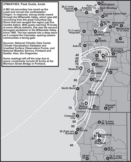
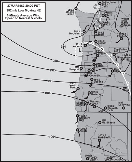
Comparative Examination of Windstorms

Class 2 Events

compiled by

Wolf Read

Class 2: Cyclones That Track Into Northwest Oregon

A typical track for Class 2 windstorms is northeast, with the low center landing between Newport and Astoria. This brings a Class 2 cyclone’s core very close to and also north of Portland, which can put the entire Willamette Valley under a storm’s most extreme south side. For the Valley, the sharpest pressure gradients have occurred during these storms, along with some fairly strong pressure couplets. These events have been second only to the Columbus Day storm in their effect across the Valley.

Very steep gradients suggest that wind velocities could be the strongest with these storms, but it appears that the northeast track doesn’t support high winds like a more northerly track would. This is primarily due to upper-air winds that aren’t parallel to the Valley’s orientation, being more SW to NE instead of the S to N that pushes a cyclone nearly due north like in a typical Class 6 situation. Indeed, on a northeast track, the storm’s overall momentum isn’t parallel to the Valley’s orientation, as it would be in a classic event like the Columbus Day storm. This limits support for south winds on the right side of the storm, again due to terrain factors. With such variables a bit out of phase, wind speeds appear to be tamed to a degree, but not enough to prevent some of the most extreme gales in the region.

A notable event outside of the modern time frame was the January 9, 1880 “great gale” or “storm king,” which is perhaps the most powerful Class 2 storm in Western knowledge. A particularly intense cyclone with a minimum central pressure of at least 955 mb as measured on two separate ships caught just off the Oregon coast, landed near Newport, then moved NE across the Coast Range, through the middle of Washington County and then between Vancouver and Kalama before racing across the Cascades. On a well-calibrated barometer operated by the U.S. Army Signal Service in Portland, the pressure fell to 967.3 mb, the lowest ever recorded at this location. A devastating gale swept western Oregon as this low moved inland. According to reports in the Oregonian, the impact was especially intense between North Bend and Newport on the Coast, and Corvallis and Vancouver inland. In the Willamette Valley, whole forests were swathed “like wheat before a reaper” according to one railroad engineer who traveled between Oregon City and Portland. Houses rolled off their foundations, telegraph service ceased and over 100 structures in Portland were damaged or destroyed. An intense west gale tore through the Columbia Gorge behind the low, with many trees breaking and raining down cliffs. Measured average wind of a few minutes duration reportedly reached 50 to 60 knots at the Signal Service office in Portland, and up to 80 knots at Umatilla. Heavy snow followed this event, reaching 10 to 15 cm in Valley locations.

04 Dec 1951

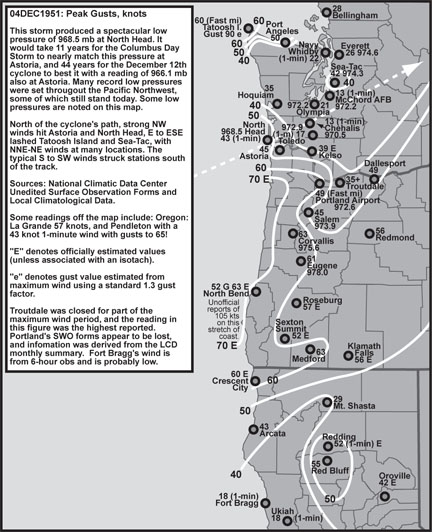
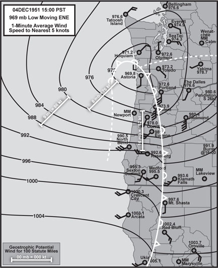
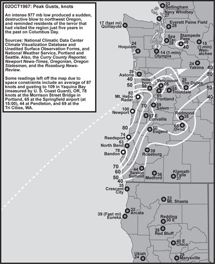
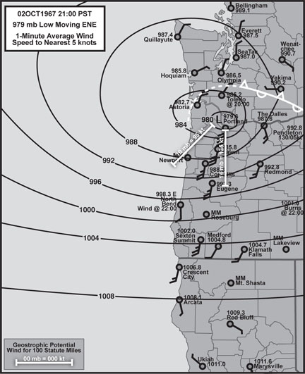
04 Dec 1951: This very deep 968 mb low moved right over Astoria and followed a ENE track into Washington. Record low pressures, if not all-time then for the month, were established in many areas of northwest Oregon and southwest Washington, including 968.5 mb at North Head, 970.5 mb at Chehalis and 972.6 mb at Portland. Pressure tendencies were quite strong with this event, especially in the pressure fall phase ahead of the low. Eugene showed an incredible drop of –6.1 mb/hr, and Portland –5.1 mb/hr: these values are on par with the Columbus Day storm. For the 1948-2004 time period, this 1951 cyclone produced the steepest Willamette Valley gradient, with a peak of +15.2 mb EUG-PDX. The measured geostrophic wind potential for the Valley, based on a +16 mb gradient over 100 statute miles at the time of the included surface map, was about 150 knots, implying the potential for 75-knot average winds near the surface. This potential was not realized, with 1-minute winds reaching 35 to 55 knots in the Valley, and 1-second gusts of 55 to 65 knots. Unofficially, gusts reached 105 knots on Oregon’s south coast. This storm was particularly damaging to timber in the Coast Range: At least 8 billion board feet of timber were toppled in Oregon in the largest windthrow event in about 40 years. For Oregon, this storm was perhaps the most powerful event of the 1950s, and was the "remembered storm" until the Columbus Day storm of 1962 claimed this status.

27 Mar 1963

27 Mar 1963: This storm was a 982 mb secondary spinup event in the base of a 972 mb Gulf of Alaska low. The secondary low followed a north-northeast track that took its center inland just north of Newport and then over Toledo, Washington. The storm’s springtime occurrence is of note, as is the fact that this storm struck only five months after the Columbus Day storm--the 1958-1967 timeframe had a particularly high windstorm frequency. The 27 Mar 1963 storm weakened as it traveled inland, which apparently resulted in a reduction of maximum gusts northward. The usual pattern in the Valley is the reverse, with maximum wind speeds generally increasing northward. Eugene’s peak 1-second gust of 65 knots would be the last time this location received winds in the 60-knot-range until the 07 Feb 2002 event produced a 5-second gust of 61. On the coast, a wind gust of 95 knots occurred at Newport. Pressure drops ahead of the storm were in the typical range for a strong Northwest storm, with many stations showing around –2.7 mb/hr. However, pressure climbs were quite strong, especially over Oregon, with North Bend showing a 1-hr rise of +7.5 mb, and Salem +6.3 mb. Compared to the 04 Dec 1951 storm, the geostrophic potential of the 27 Mar 1963 event was much less, with 10 mb over 100 statute miles across the Willamette Valley indicating a 95 knot 1-minute wind, which suggests a peak average wind of about 45 knots with gusts to 65 down in the lowest layers of the atmosphere. Therefore, the 1963 cyclone more closely realized its geostrophic potential than the 1951 cyclone. The more northerly track may, in part, explain the difference.

05 Feb 1965

05 Feb 1965: This storm moved inland over Astoria as barely more than a 994 mb open wave. Nevertheless, a particularly intense gradient set up along this storm’s south side, reaching +13.0 mb in the Willamette Valley. The geostrophic potential with this gradient was around 125 knots, indicating the potential for 60 knot 1-minute wind near the surface with gusts to 85. This potential wasn’t quite realized, with wind velocities in the 25 to 40 knot range and gusts of 50 to 60, and in the case of Troutdale 70 knots. The NE track (instead of N) likely contributed to the unrealized potential. Though this event was perhaps the least intense of the four described here, it was quite damaging in the narrow region that was effected: "Hundreds of trees blown down, many across power lines, some on cars and buildings, and many across highways causing the temporary closing of many roads. Large numbers of outdoor signs, roofs, and windows badly damaged or destroyed,” according to the National Climatic Data Center's Storm Data for 1965.

02 Oct 1967

02 Oct 1967: This 977 mb primary cyclone was perhaps the earliest strike in the storm season by any significant windstorm since 1948. This storm also capped the series of similar events 1963-1967 described here. The 1967 cyclone brought an incredible +13.7 mb gradient into the Willamette Valley, second only to the 1951 storm. The gradient’s geostrophic potential of 135 knots indicates the possibility of 1-minute winds of 65 to 70 knots with gusts of 90 to 95. In the Valley, Portland came closest to matching this, with a fastest mile of 61 knots, second only to the Columbus Day storm. The reported maximum gust, however, was 68 knots: this was the highest official reading in the Valley. On the coast, gusts reached as high as 100 knots at Newport and 78 at Bandon. Again, as with other storms of this track, the easterly component of motion indicates upper-air support that’s out of sync with the north-south mountain ranges, a fact that likely tempered the winds somewhat. This is a common theme among Northwest windstorms, one that appears to prevent a higher frequency of more intense windstorms such as the Columbus Day storm of 1962.

Notes

Other notable Class 2 events include 10 Nov 1951, 01 Mar 1974, 11 Jan 1988 and 08 Jan 1990.

Last Modified: September 21, 2007
Page Created: February 11, 2006

You can reach Wolf via e-mail by clicking here.

| Back |