Comparative Examination of Windstorms

Class 4 Events

compiled by

Wolf Read

Class 4: Cyclones That Track Into The Olympic Peninsula

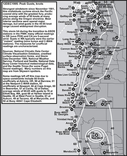
A typical track for Class 4 windstorms is northeast, with the low center landing between Hoquiam and Tatoosh Island, WA. This brings a Class 4 cyclone's core very close to and also north of Seattle, which can put the entire Puget Lowlands and Northwest Interior under a storm’s most extreme south side. For the Washington Interior, the sharpest pressure gradients have occurred during these storms, along with some fairly strong pressure couplets. These events have been second only to the Columbus Day storm in their effect across much of the Interior region.

Very steep gradients suggest that wind velocities could be the strongest with these storms, but it appears that the northeast track doesn’t support high winds like a more northerly track would. This is primarily due to upper-air winds that aren’t parallel to the interior-lowlands orientation, being more SW to NE instead of the S to N that pushes a cyclone nearly due north like in a typical Class 6 situation. One exception appears to be the Chehalis Gap in Southwest Washington. Sometimes intense SW winds are supported in the southern Puget Lowlands due to this large terrain gap, especially in the vicinity of Shelton and Olympia. On a northeast track, the storm's overall momentum isn't parallel to the general interior-valley orientation, as it would be in a classic event like the Columbus Day storm. This limits support for south winds on the right side of the storm, again due to terrain factors. With the gradient-orientation, terrain-orientation and upper-airflow variables a bit out of phase, wind speeds appear to be tamed to a degree, but not enough to prevent some of the most extreme gales in the region.

Even despite a track that brings the storm center in fairly close proximity, these storms tend to spare the Willamette Valley a major gale, though sometimes damaging gusts reach as far south as Portland and Salem. It appears that, in most events of this type, maximum winds reach about 35 mph gusting 50 in the Willamette Valley, compared to 45 mph gusting 65 in the Puget Lowlands. In a rough relationship, the deeper the low, the greater that chance that damaging winds will turn up in the Willamette Valley.

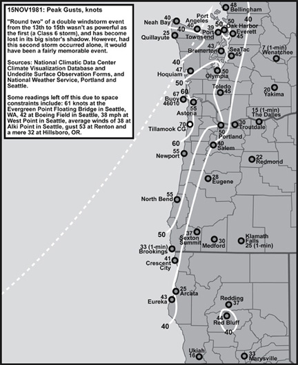
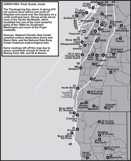
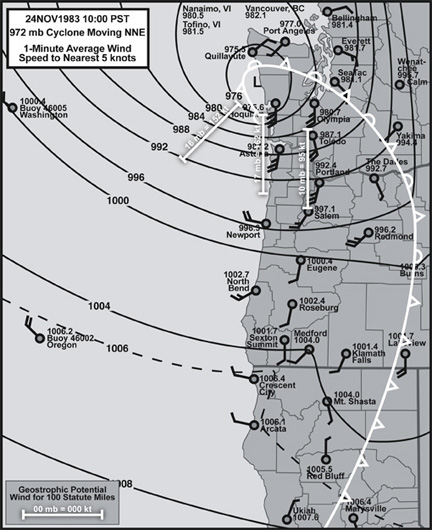
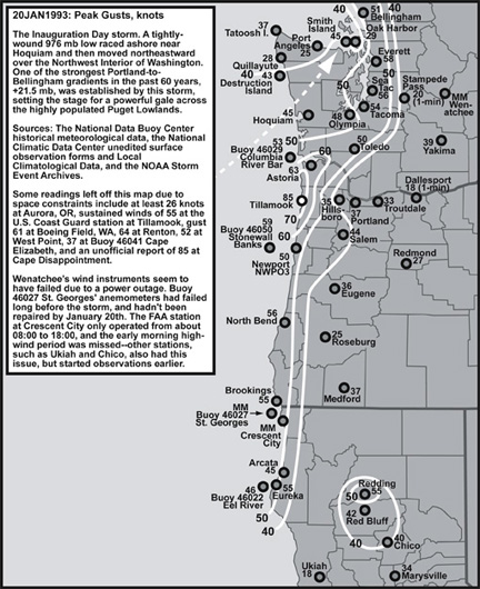
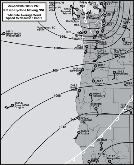
Of the four storm events shown below, the first three are of remarkable similarity in track and perhaps even developmental stage. The three scenarios provide a wonderful opportunity for comparison, especially in terms of differences in maximum wind speed distribution that may be associated with variation in cyclone depth at landfall (972 mb for 24 Nov 1983, 980 mb for 20 Jan 1993 and 987 mb for 15 Nov 1981) and also variation in other structural features (such as location and spread of strong gradients relative to the low center). Every cyclone is unique, a fact that is clearly demonstrated by these three "sister" storms.

15 Nov 1981

15 Nov 1981: A noteworthy event in part due to its close association with a much bigger storm that occurred the day before. Following closely on the heels of the massive 14 Nov 1981 Class 6 "Classic Event," this 987 mb low tracked inland just north of Hoquiam on a NNE path into Washington. The storm was a fast-mover, and this is reflected in some fairly intense pressure tendencies, including -4.7 mb/hr at North Bend as the low approached the station, and +6.8 mb/hr at Astoria as the low moved inland to the north. These pressure changes are sharper than this storm's much stronger 14 Nov 1981 predecessor. Typical of lows of this depth (say 980 mb and above), the strongest winds were focused in a fairly narrow region, generally from Newport, OR, to about Hoquiam, WA, and then inland in a northeast-trending swath and striking Portland, OR to Bellingham, WA, fairly strongly. This windstorm, though quite powerful, pales against the major blow from the day before.

24 Nov 1983

24 Nov 1983: A strong 972 mb cyclone moved inland just north of Hoquiam, WA, and delivered a damaging gale on Thanksgiving Day. This storm had a well-developed bent-back occlusion that swept the Southwest Washington coastline quite intensely. Peak gusts at Hoquiam were comparable to the Columbus Day Storm of 1962. Interestingly, maximum wind speeds at Quillayute, which ended up north of the low's landfall, were relatively gentle. The Thanksgiving Day storm of 1983 had a large area of tight gradient, and the low moved fairly quickly, resulting in a strong pressure couplet over much of the region. Pressure rises in excess of +4.0 mb/hr, and in some cases above +5.0 mb/hr, occurred in the Willamette Valley, Puget Lowlands and along the Oregon and Washington coastlines. Though this storm was significantly deeper than the 20 Jan 1993 event (detailed below), wind speeds were generally about the same, if not a tad slower (allowing for differences in the strike zone of highest gusts). Greater depth doesn't always mean steeper gradients. Indeed, there's plenty of evidence to suggest that once a cyclone gets underway, the gradient is somewhat independent of depth. Gradient seems more related to where the storm is in its developmental cycle. Peak gradients tend to occur around peak intensity, with a slow relaxation of pressure differentials afterward. Depth appears to determine how far from the center steep gradients will occur, with a greater reach for the deeper storms.

20 Jan 1993

20 Jan 1993: The well-known Inauguration Day Storm landed just north of Hoquiam as, perhaps, a 978 to 980 mb system. This event ranks among the most damaging windstorms in Western Washington. Unlike 24 Nov 1983, and perhaps more like 15 Nov 1981, the focus of the storm's fastest winds was along the north Oregon coastline. The Willamette Valley stations reported remarkably low wind speeds given the depth of this storm and the intensity of winds in the Puget Lowlands. Clearly, this low was quite compact, and the region of maximum gradient swept inland just north of Portland, OR, despite raking the coastline to the immediate west, due to the low's northeast track. Note the peak gusts in the Puget Lowlands, which are higher than those on the Washington coast, including Hoquiam. During the 20 Jan 1993 event, the Puget Lowlands, and Northwest Interior, received the most damaging gale since the massive 14 Nov 1981 storm. Some amazing pressure tendencies were observed on the coast, and inland, with the Inauguration Day Storm, including +8.0 mb/hr at Astoria, OR, +8.3 mb at Destruction Island, WA, and +7.0 mb/hr at Olympia, WA.

12 Dec 1995

12 Dec 1995: At 960 mb as it crossed the coastline, this incredibly large and powerful cyclone may have been the deepest storm to make landfall in Washington on record, and certainly for the 1948-present era. At one point offshore, the low had a 953 mb (28.14") central pressure. This event caused extensive wind damage from the San Francisco Bay Area northward into parts of extreme southwest British Columbia. The storm's area of effect, especially in terms of distribution of 50-knot-plus gusts, far exceeds the other three events explored on this page. Given this reach, the 12 Dec 1995 storm was very similar to the Class 6 "Classic Events." However, due to a track more NNE than N, the 1995 storm is put in Class 4. This distinction isn't clear-cut, and serves as a reminder that wind speeds can be fickle, even in big events, and there tends to be gray areas among classification bins. This storm appears to fit neatly between Class 4 and Class 6--some of this is clearly due to the storm's incredible depth. Like the other three storms on this page, the 12 Dec 1995 event brought with it a strong pressure couplet, with declensions generally in the -3.0 to -4.0 mb/hr range, and climbs generally in the +3.5 to 5.0 mb/hr range. Record low barometric pressures were set at many stations in Washington and in parts of Oregon.

Notes

Other notable Class 4 events include 24 Feb 1958, 26 Mar 1971, 21 Dec 1982 and 27 Dec 2002.

Last Modified: September 23, 2007
Page Created: September 23, 2007

You can reach Wolf via e-mail by clicking here.

| Back |