October 18, 2007 Gale

compiled by

Wolf Read

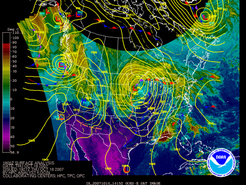
On October 17-18, 2007, a somewhat unusual "warm-core" (relatively speaking) extratropical cyclone developed far off the Oregon coast and moved northeastward over Tatoosh Island. This low developed from the remnants of tropical storm Linling. Another cyclone developed right on the heels of this tropically-fed low, cutting off a large supply of cold air that probably would have contributed to a much stronger storm. This resulted in a system that failed to show the classic comma-shape on satellite photos. Indeed, the low's center proved hard to find, even for National Weather Service Forecasters, as indicated in their forecast discussions. The development of a bent-back occlusion was largely arrested, a typical feature among high-wind-generating cyclones and often the region of strongest pressure gradient and wind speeds. However, the weak pool of cold air made for a very warm and blustery day in the Pacific Northwest, and a somewhat unique storm in that frontal boundaries were poorly defined. Indeed, it appears that the leading warm front had the strongest signature, a position usually held by a storm's cold front. As the warm front eroded a cold air pool in place at the surface, the strongest winds typically began, with the exception of some places favored for easterly winds ahead of the incoming low.

Figure 1, below, is courtesy of the Hydrometeorological Prediction Center, and shows the cyclone just off the Washington coast at 11:00 PDT on October 18, 2007. In the tight gradient south of the low's 986 mb (29.12") center, winds had reached damaging levels along the Oregon coast by this time.

Here are my journal notes:

October 18, 2007: Thursday

09:00 PDT: (Corvallis, OR) The HPC surface analysis for 12:00 UTC shows the low at about 46ºN and 130ºW with a central pressure of 984 mb. The low doesn’t have a very clean form—looks a little ragged with a stretched out front running far ahead of the center—but it clearly has some wind potential. Southerly winds have been escalating over much of western Oregon over the past few hours. At the Corvallis Airport, winds are now (09:15) at S 24 mph gusting 30 with the temperature up to 54ºF (from 48ºF at 06:55). So far, S winds have gusted to 35 mph at Eugene, 33 mph at Salem, and they're still ESE at Portland, with gusts up to 29 mph around 07:53. The coast is already getting pummeled. Newport reported SSW 43 mph gusting 64 at 07:32 and SSW 44 mph gusting 62 at 08:11. Apparently Hwy 20 is closed due to toppled trees across the roadway--heard this from a friend by e-mail. At Astoria, winds are just now shifting SE from a long period of easterlies. North Bend had a peak wind of SSW 36 mph gusting 55 at 08:35. Looks like winds are already diminishing on the south coast.

Barometric pressure is falling fastest at Tatoosh Island compared to more southerly stations, which suggests that the low is tracking NE and toward the tip of the Olympic Peninsula. At 09:01, the pressure at Tatoosh was 992.0 mb, down from 994.9 mb the hour before, with E winds of 49 mph gusting 57. Destruction Island shows 991.3 mb at 09:01, down from 993.4 the hour before. Winds have shifted from the E to SE in the last hour and are at 32 mph gusting 39. At Astoria, the barometer was 995.7 mb (29.40" alt) at 08:55, down from 996.5 mb (29.43" alt) the hour before. Winds are SE 7 mph. 09:50 PDT.

12:03 PDT: Interesting, in the last fifteen minutes or so, a big gust blew through OSU campus, tearing through the trees outside. I'm in Strand Ag Hall, at the Oregon Climate Service.

The 11:55 obs at CVO shows SW winds of 25 mph gusting to 37, for the highest value yet. And the temperature is 64ºF. Rockhouse 1, at 1,797 feet in the Oregon Coast Range perhaps 30 miles to the NW of here shows SW 34 mph gusting 56 with a temperature of 52ºF and 1.29" of rain in the past 24 hours. At 11:54, EUG showed 62ºF with SW 22 mph gusting 31. Valley stations are generally gusting 20 to 35 mph. Aurora had a gust to 38 mph at 10:50.

South winds are showing up in Washington's SW Interior as far north as Olympia now. Kelso was raked with SSE 26 mph gusting 43 at 09:55. And just recently, OLM had S 24 mph gusting 43 at 11:54 compared to SSW 9 mph at 10:54. SLP was 994.5 mb (29.37" alt) at the time of the 43 mph gust. Fort Lewis (GRF) also had winds of SSE 24 mph gusting 43 at 11:55 with a temperature spike up to 59ºF from 45ºF at 09:55. At 11:53, Sea-Tac Airport had variable winds of 3 mph with a SLP of 995.3 mb (29.37" alt), with the temperature starting to rise at 52ºF. Hoquiam had S winds of 29 mph gusting 49 at 11:27 with the temp up to 61ºF and the pressure at 993.1 mb (29.32" alt) during the 11:53 obs. SE winds of 10 mph gusting to 22 just picked up at Quillayute at 12:07--during the regular 11:53 observation, winds were NE 5 mph, and the pressure was at a low 988.8 mb (29.20" alt).

Looking south, Astoria is in the thick of things now: SSW 36 mph gusting 55 at 11:55, with a SLP of 995.9 mb (29.41" alt) and rising from a low of 994.7 (29.38" alt) the hour before. Peak wind 58 mph at 11:40, just into high-wind criteria. Tillamook RAWS shows 24 mph gusting 44 at 11:12, and at the airport, winds reached WSW 38 mph gusting 59 at 11:30.

This is quite the event for so early in the season. 12:26 PDT.

13:07 PDT: At 11:56, Astoria had a peak gust of 60 mph out of 200º. Mt. Hebo, by the way, had a peak gust of 83 mph at 10:49. And since I'm in Coast Range country, Rockhouse 1 showed SW 38 mph gusting 59 at 12:12.

Olympia and Tacoma McChord peak gusts are now at 46 mph, at 12:18 and 12:29 respectively. At the 12:01 observation at Tatoosh Island, E winds continued at 43 mph gusting 48 and the barometer continued to fall at 988.1 mb, down from 989.3 mb the hour before. Peak easterlies so far have been 51 mph gusting 59 at the 10:01 obs. At 12:01, Destruction Island had a barometer of 987.9 mb with SE winds of 44 mph gusting 48. At the recent 13:01 obs, the barometer was rising at 988.4 mb with winds at SSE 38 mph gusting 41. Looks like the low is beginning to move ashore. 13:14 PDT.

13:38 PDT: Surface pressure down to 987.0 mb at Tatoosh for the 13:01 observation. East wind 44 mph gusting 47.

Rockhouse1 now SW 44 mph gusting 65 at 13:12. Wind still quite gusty here, tearing the yellow leaves from the trees at times and rushing quite loudly.

At 13:06, winds were S 33 mph gusting 49 at Fort Lewis. 13:42 PDT.

14:05 PDT: Went out to get a little lunch. The quad is littered with many dead branches and twigs, along with a vast carpet of leaves. A large tent is being put up for an upcoming event--the 30-35 mph gusts probably aren't helping any. The air feels very warm, and a little muggy. During gusts, the wind streams through the trees loudly. Many leaves have found their way inside the building at the various entrances as students stream in and out to attend classes. 14:07 PDT.

21:36 PDT: Looks like a developing storm in the heels of today's event cut off the cold air inflow, and prevented the storm from getting any stronger than about 986 mb. The low filled fast as it moved northeastward over the tip of the Olympic Peninsula. At 16:00, it was analyzed at 993 mb by the HPC with the center just south of Vancouver, BC.

However, though winds in the north Willamette Valley weren't particularly strong, the system had some punch in the Western Washington interior. Olympia's peak was already noted at about 46 mph. However, not too far away, Fort Lewis had a S gust to 58 mph at 13:40. This is probably the highest gust reported in the Puget Lowlands on official anemometers. Tacoma McChord had a peak gust of S 48 mph at 13:00 and then again at 15:49 out of the SSW. Sea-Tac, which had a high of 60ºF during this warm storm, had a fairly punishing peak gust of SW 53 mph at 16:09. Renton showed S 46 mph at 15:21. Boeing Field peak at just S 41 mph at 14:21 and again at 15:24. Quite a disparity there between these stations, and a reflection of very gusty and fickle winds. Peak 2-minute velocities at both Sea-Tac and Fort Lewis were around 30 mph in the reports, despite gusts into the 50s. Such gustiness is similar to the Columbus Day storm, though the velocities are much lower. Everett, Paine Field, got a substantial blow from this storm, with gusts of 40 mph and higher from 13:53 to 19:53, and a peak gust of SSW 56 mph at 15:49. According to NWS, Seattle, it looks like a mesolow set up in the lee of the Olympics and enhanced the winds in the north Sound region. Further north, the winds were reduced: Arlington's peak was S 41 mph at 15:35 and Bellingham had a brief attack of SE to S winds that peaked at SE 51 mph at 15:50. Low pressure occurred at 15:53 and reached 991.2 mb (29.25" alt).

On the north coast, Quillayute didn't have particularly strong winds, peaking at S 29 mph at 14:41. Likely a close proximity to the filling low center contributed to this. Low pressure reached 988.4 mb (29.19" alt) at 12:53. Hoquiam had a peak gust of S 56 mph at 13:55. Low pressure at Tatoosh was 987.0 at 13:01 as mentioned before with winds going from E to ENE to NNE to N to NW to SW then S and SSE over consecutive hours beginning with the 14:01 observation and not getting that strong (SW 13 mph gusting 23 at 18:01 for example). Looks like the low center went right over Tatoosh.

There were many reports of downed trees and broken power lines in western Oregon and Washington. A power outage in Kelso left about 4,000 residents with darkened homes. METAR data interruptions in places like Olympia suggest outages. Gusts into the 50-mph range with many trees still full of leaf are likely to result in widespread disruption as branches and trunks fail under the load. I noted some big branches, one from a large sweet gum near 29th and Jefferson, down around town. The peak winds at Corvallis Airport reached SW 28 mph gusting 39 at 14:15, among the strongest in the Valley.

The developing storm that cut off the cold air to today's system is now approaching the coast. A broad shield of rain, sometimes moderate to heavy, has spread over Oregon and Washington. I'm listening to the water plunk around the house as I write these words. Temperatures have lowered considerably, with 57ºF at CVO at 21:55. We've had 0.17" of rain in the last hour, and the altimeter reads 29.61" and falling at a pretty good clip, from 29.65" at 20:55. Winds are SE 3 mph.

This next system, which may arrive as a strong open wave, could bring in a tighter gradient over the Willamette Valley as the triple point moves ashore in the vicinity of Astoria. It could also arrive as a cyclone. The back edge of the system, demarked by a strong dry slot, is just now crossing 130ºW. Buoy data for 46005 and 46002 aren't revealing super-fast development with this system. Nothing jumping out. Indeed, the barometer at 46002 showed a minimum pressure of 29.57" at 18:00 and winds have now picked up to WNW 27 mph gusting 31 during the 21:50 observation, with a barometer of 29.66" and rising 0.05" in the past hour. Lowpres at 46005 was 29.42" at 19:50. We'll see how this system develops overnight. 22:30 PDT.

October 19, 2007: Friday

08:33 PDT: (Corvallis, OR) The second weather system did not undergo cyclogenesis as it washed ashore. The triple-point crossed the coastline between Newport and Astoria and tracked ENE inland. Places south of this point received some southerly winds that accompanied warmer air for a few hours before the cold front pushed inland and knocked temperatures down.

The warm air signature was fairly strong at Eugene, where the temperature climbed from 57ºF at 00:54 to 61ºF by 02:52 with S winds of 9 to 10 mph. At the 02:52 time stamp, W winds had arrived and they eventually escalated to 15 mph gusting 25 by 04:54, with the temperature dropping back to 57ºF. Minimum pressure was 999.9 mb (29.53" alt) at 01:54 just before the west winds arrived. By 07:54, the temperature was down to 50ºF and the barometer had risen to 1009.7 mb (29.82" alt) and winds were back to S at 7 mph. Rainfall with this storm was quite heavy at times, with 0.36" falling in the hour ending 00:54, and 0.20" to 0.34" falling from 21:54 to 23:54. The 24-hour total ending at 04:54 this morning was 1.68".

The outcome of the storm here in Corvallis was similar, with a peak temperature of 61ºF, modest winds, a minimum pressure of 29.52" (alt), a peak 1-hr rainfall rate of 0.36" (ending 00:55), and 1.35" in the 24-hrs ending 04:55. The Finley National Wildlife Refuge station showed 0.39" of rain in the hour ending 00:45, with 1.55" accumulating in the 24-hours ending 04:45. At Salem, the warm air signature was not as strong, with a high of 58ºF at 04:56 from a cooler 54ºF at 02:40, and it was of shorter duration. Max winds SW 16 mph gusting 24 during the warmest phase at 04:56. Lowpres 998.9 mb (29.50" alt) at 00:56. Peak 1-hr rainfall 0.14" at 23:56 with a 24-hour total of 0.74" ending at 04:56. The warm signature is barely noticeable at Portland, with a temperature climb from 55ºF at 04:53 to 57ºF by 05:10 as S winds briefly escalated to 15 mph. Lowpres was 29.51" (alt) at 01:53. Interesting--no standard hourly SLP readings (in mb) are being reported at PDX at this time. Peak 1-hr rain 0.10" at 05:53 yesterday as the moderate windstorm moved toward the coast. The 24-hour total ending at 04:53 was 0.58".

During yesterday's wind event, the peak gust at PDX was SW 36 mph at 15:24. The peak gust at HIO was SW 32 mph at 12:49. During the afternoon, as the blustery winds blasted leaves and branches from the trees, temperatures became quite warm, though perhaps not that unusual for a mid-October day. The table below lists some of the inland highs:

High Temps During the 18 Oct 2007 Wind Event
Location
Max Temp
Portland
65ºF
Salem
63ºF
Corvallis
66ºF
Finley WR
65ºF
Eugene
65ºF
Roseburg
69ºF

That about covers the latest round of weather. Yesterday, while I was at the OCS, a friend and I both commented on how this October is really feeling like a November. It seems we're about three to four weeks ahead on the arrival of winter weather. 09:06 PDT.

October 18, 2007: Comparative Meteorological Details
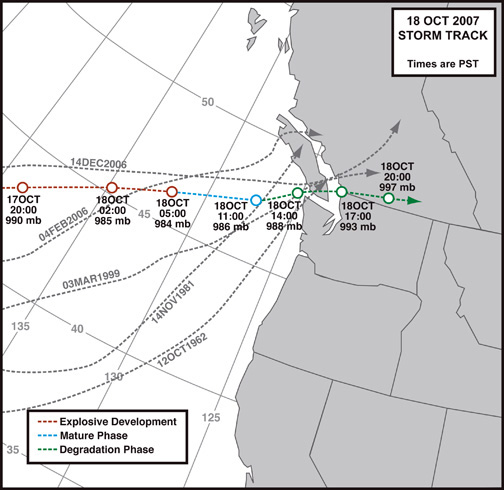
Storm Track


Figure 2, above, outlines the storm track for the October 18, 2007 windstorm. Positions were based on Hydrometeorological Prediction Center surface maps, and water vapor satellite photos collected from the NWS at the time of the storm. Compared to many past windstorm events, some of which are included in the figure, this cyclone developed at a much higher latitude, and followed a more easterly track. Thus sparing most of California, and parts of Oregon a more serious hit. Interestingly, the October 18, 2007 storm closely followed the track of the December 14-15, 2006 windstorm.


General Storm Data

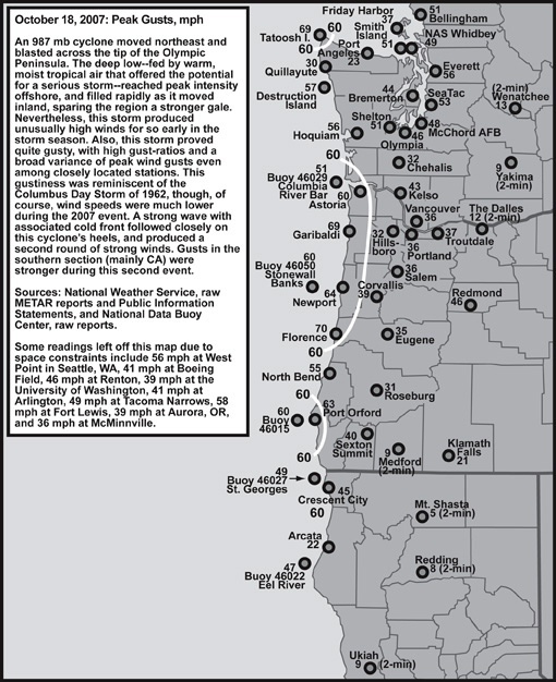
Peak Wind and Gust

Table 1, below, lists the peak wind and gust for eleven key stations in the Pacific Northwest, their direction, and their time of occurrence. "Peak Wind" is a 2-minute average, and "Peak Gust" for many stations is a 3-second average. Over the past year or so, the NWS has changed its cup anemometers to sonic systems, and has adopted a 3-second gust in place of the 5-second gust that was instituted in the mid-1990s with the implementation of ASOS. For a given surge of wind, a 3-second gust on a sonic anemometer will tend to be higher than a 5-second gust on a cup anemometer. Indeed, a 3-second gust on the highly-sensitive modern systems may be close to replicating the 1-second "instant" gust on the analog equipment used by the NWS before the advent of ASOS. Keep this in mind when comparing the data for this storm to events in the past.

By my own personal methodology, a wind event rates the term "windstorm" when the average peak gust of these eleven stations reaches 39.0 mph (gale force) or higher. This ranking favors those storms that follow a northward path close to the U.S. Pacific Coast, and for good reason--such storms affect the largest land area, and therefore are potentially the most destructive. The October 18, 2007 cyclone did not follow such a path, tracking inland on a ENE-ward path across the Olympic Peninsula instead, and the focus of damaging winds was primarily in the northern part of the region under consideration.

With an average peak gust of 39.6 mph, the October 18, 2007 storm just made the "minor windstorm" category. Moderate windstorms have an average of 45.0 to 54.9, and major windstorms are those that reach or exceed 55.0. Only a handful of storms have made the majors, including December 12, 1995 with 60.5, November 14, 1981 with 65.9 and October 12, 1962 with 80.5.

The October 18, 2007 windstorm, is mainly noteworthy due to its early-season arrival. This kind of wind event would is more typical in the months of November through March. Gusts of 35 to 50 mph during early autumn are capable of causing significant power interruption and other wind hazards due to trees shedding dead and dying branch material that may have accumulated over the less windy summer season. Furthermore, deciduous trees generally haven't lost their leaves by mid-October, and all these little foils not only add extra weight (which means more stress on the trunk when the tree is leaning) to the tree, but also much more wind resistance than during leafless winter months. Roughly speaking, a windstorm with 35 to 50 mph gusts in mid-October probably has the potential for disruption similar to an event with 45 to 60 mph gusts in December. One ameliorating effect is the tendency for soils to be drier in October (end of dry season) than during the generally rainy winter months, which appears to result in a lower frequency of tree root-failures during early-season storms.

Location

Peak
Wind
mph

Direction
Pk Wnd
degrees

Obs Time of
Peak Wind
PST

Peak
Gust
mph

Direction
Pk Gst
degrees

Obs Time of
Peak Gust
PST

California:            
Arcata [1]

14

140º

07:53 HRS, 18th

22

140º

11:53 HRS, 18th

Oregon:            
North Bend

37

200º

07:35 HRS, 18th

55

200º

08:35 HRS, 18th

Astoria

36

200º

10:55 HRS, 18th

60

200º

10:56 HRS, 18th

Medford [2]

9

020º

11:53 HRS, 18th

12

020º

11:53 HRS, 18th

Eugene

24

190º

06:54 HRS, 18th

35

190º

06:48 HRS, 18th

Salem [3]

21

180º

10:56 HRS, 18th

36

170º

09:08 HRS, 18th

Portland

22

120º

08:54 HRS, 18th

36

220º

13:24 HRS, 18th

Washington:            
Quillayute [4]

18

200º

15:53 HRS, 18th

30

220º

14:59 HRS, 18th

Olympia

25

200º

13:01 HRS, 18th

46

180º

12:18 HRS, 18th

Sea-Tac

33

200º

13:53 HRS, 18th

53

220º

16:09 HRS, 18th

Bellingham

25

150º

15:53 HRS, 18th

51

140º

15:50 HRS, 18th

             
AVERAGE

24.0

164º


39.6

173º


Table 4 Notes:

[1] Peak gust at Arcata is the last of three occurrences in the METAR data, the other to occurring in the 05:53 and 07:53 observations.

[2] Peak gust at Medford is estmated from the peak 2-minute wind via a 1.3 gust factor. Peak 2-minute wind is last of two occurrences, the other happening at 10:53.

[3] Peak 2-minute wind at Salem is last of two occurrences, the other happening at 07:56.

[4] Peak 2-minute wind at Quillayute is the last of two occurrences, the other happening at 14:41.


Peak Gusts in the Seattle Area: 18 Oct 2007 A Strong Gale for Early Autumn

Table 5, below, lists Seattle-area peak gusts, in mph, for recent storms (those that have struck since ASOS was fully implemented). The data reveal that, for the greater Seattle area, the October 18, 2007 windstorm falls in the lower range of recent gales. However, it's early-season (mid-October) nature makes this event somewhat unique. October windstorms are rare, with the last significant event occurring on October 22, 1982, and only a scattering of big windstorms over the last six decades, including October 21, 1934, October 26, 1950 and October 12, 1962.

Storm
Tacoma McChord
SeaTac Airport
Renton Airport
Boeing Field
West Point
U of W ATG
Everett Paine
Average
18OCT2007
48
53
46
41
56
39
56
48.4
15DEC2006
69
69
51
56
70
55
66
62.3
04FEB2006
47
47
44
47
66
48
52
50.1
01JAN2006
41
49
40
40
54
40
45
44.1
25DEC2005
40
38
38
35
48
35
48
40.3
27DEC2002
51
52
49
48
59
56
58
53.3
16JAN2000
60
52
53
54
69
55
60
57.6
03MAR1999
55
60
51
52
68
MM
57
57.2

Last Modified: November 16, 2007
Page Created: November 7, 2007

| Back |