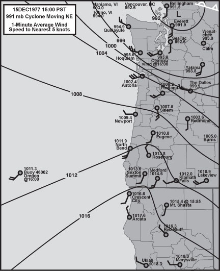
Comparative Examination of Windstorms

Class 3 Events

compiled by

Wolf Read

Class 3: Cyclones That Track Into Southwest Washington

The typical track for a Class 3 high-wind generating cyclone is NE, with a landfall between Hoquiam and Astoria. Often, this path brings the low center right over the Puget Lowlands. Interestingly, for the 1948-2004 time period, this path seems to have been less frequented than others, including Class 2. Storms following this track have also caused some of the more unusual high wind situations, including the production of damaging wind far south of the low. Two of these scenarios are included here: 24 Feb 1961 and 07 Dec 1968. The 04 Dec 1951 windstorm, placed in the Class 2 section above, is on the margin between Class 2 and 3 events for it appears to have tracked right over Astoria.

03 Nov 1958

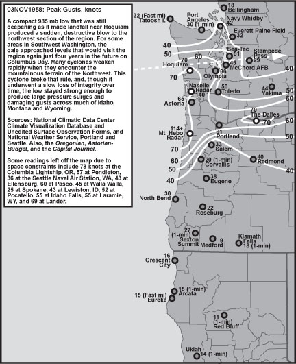
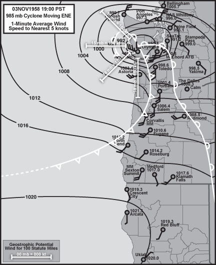
03 Nov 1958: This very intense 985 mb low moved ashore right over Hoquiam on a path that was nearly due east, which put the low just north of Olympia and between Sea-Tac and Tacoma on its way into the Cascades. Like the 10 Nov 1975 and 07 Feb 2002 events, the cyclone was developing explosively as it moved inland, making for a particularly aggressive windstorm. There’s evidence for a central pressure drop of at least 20 mb in six hours just before the low reached the Pacific Coast. The barograph trace at Hoquiam has a sharp "V" like a hurricane. Pressure tendencies at this location included -7.1 mb/hr as the low neared, and +13.9 mb/hr as the cyclone moved into the Puget Lowlands. Like Hoquiam, Olympia’s barometer recorded some incredible pressure changes, including a +9.8 mb/hr surge. During the space of three pressure observations--two hours--the HQM-OLM gradient shifted from -7.4 mb to +7.4 mb. Other notable pressure gradients include +35.2 mb ACV-HQM, +17.3 mb AST-HQM with -13.6 mb HQM-TTI at the same time, +13.2 mb PDX-OLM and +8.4 mb TDO-OLM (37 statute miles). These values suggest a geostrophic wind potential at around 200 knots. The predicted 100-knot 1-minute winds at the surface were not realized, being about 50% of expected, likely due to unfavorable track direction relative to terrain features; nevertheless, due to the storm’s intensity, wind velocities at some stations were among the highest in the period of record.

At Hoquiam, wind direction went through many compass points with this storm, starting out E as the low approached, shifting to a S whole gale for a brief time as the low’s leading front went through and then swinging W to NW at near hurricane force as the low passed to the east. For Hoquiam, 1-minute wind reached 45 knots with a gust to 70, on par with the Columbus Day storm. Olympia also went through a series of intense wind changes, with no less than three periods with significant acceleration, suggesting a very complex structure to this storm. Maximum winds, out of the south, reached 52 knots gusting 66, values second only to the Columbus Day storm. Also of interest was the particularly strong NW wind at Sea-Tac, with a gust to 51 knots, which suggests that a well-developed bent-back occlusion swept through the area. The storm’s focused area of wind attack is also noteworthy, with wind velocity decreasing quickly south of an Astoria to Portland line and north of Hoquiam to Seattle. Oregon’s south coast and northern California were barely even influenced by this cyclone. Aided by one of the highest positive AST-DLS gradients in the 1948-present time period, +8.8 mb, and the easterly track of the low, a particularly damaging westerly gale tore through the Columbia River Gorge. The Dalles reported its highest wind speed for any windstorm in this study, with winds of 52 knots gusting 70, values that apparently caused significant disruption to the region’s high-voltage electrical grid.

24 Feb 1961

24 Feb 1961: This situation is somewhat of a unique setup compared to many of the windstorms examined on these web-pages, and is a reminder that there is more than one way to generate a significant high wind event. A weak low that set up along a Pacific frontal boundary moved into southwest Washington. As the low did moved across the Cascades, a positive-tilt trailing front swept into Oregon. High winds struck much of southwest Oregon on this day, especially inland and at the higher elevations, such as in the Cascades. These S to SW winds reached velocities above 60 knots at Eugene as pressure gradients were relaxing and only about +1.2 mb for the EUG-PDX measure. Eugene appears to have been on the northern edge of a stronger gradient to the south, which was at +7.3 mb for the MFR-EUG measure during the period of maximum wind velocity at Eugene. Note, however, that this gradient, though fairly strong, isn't all that unusual for a winter storm--storms that produce much less wind. Perhaps one of the things going for this event is that the isobars appear to have aligned nearly perpendicular to the north-south trending valleys ahead of the front, a situation which strongly supports ageostrophic airflow. Also, given an elevated temperature at Eugene, 59ºF during the high wind period, there's evidence for some strong vertical mixing ahead of the boundary--downdrafts that could have carried momentum down from the upper atmosphere.

07 Dec 1968

07 Dec 1968: Like 24 Feb 1961, this is another case of a southwest Washington low that resulted in strong wind developing far south of the cyclone. In this case, a fairly vigorous gale swept inland in a strong pressure gradient field south of a triple-point that appears to have been in the initial stages of cyclogenesis. Likely, the warm air advection field contributed to the strength of the airflow by scouring out cold air trapped at the surface, taking away a boundary layer that could have acted as a shield against momentum mixing down from higher up. However, gradients were particularly intense with this system, and included +9.3 mb from EUG-PDX, which is a value comparable to many big windstorms such as 14 Nov 1981, and the ACV-AST measure peaked at +19.0 mb, with OTH-AST at +14.0, both quite strong.

15 Dec 1977

15 Dec 1977: This cyclone followed a path similar to 03 Nov 1958 (above), with a bit more northerly component to its track. Given some intense pressure gradients during the 1977 storm, such as +10.3 mb EUG-PDX and +30.0 mb ACV-AST, measures that are on par with many great storms of history including 12 Oct 1961 and 14 Nov 1981, it is a bit surprising that wind speeds weren't faster with this storm. Indeed, save for a small stretch of the north Oregon and south Washington coast, peak wind velocities in many areas weren't even comparable to the already-mentioned and very intense 1958 storm. The 1958 storm was undergoing explosive development as it rolled onto the coast. The 1977 cyclone was in a mature, degrading phase as it rolled ashore, and this likely accounts for the difference in wind intensity. Note that gale force winds extended further south of the 1977 low, probably because of the more northeasterly track, which broght the storm's center closer to Oregon's southern coastline. Astoria had a fairly strong pressure surge with this windstorm, peaking at +5.8 mb/hr, which correlates well with Astoria's fast peak gust, and a narrow belt of very tight gradient that developed on the south side of the cyclone's broad center, visible on the surface map provided above.

Notes

Other notable Class 3 events include 05 Nov 2005.

Last Modified: February 24, 2006
Page Created: February 11, 2006

You can reach Wolf via e-mail by clicking here.

| Back |