Two Windstorms in
Three Days a perspective by Wolf Read |
|
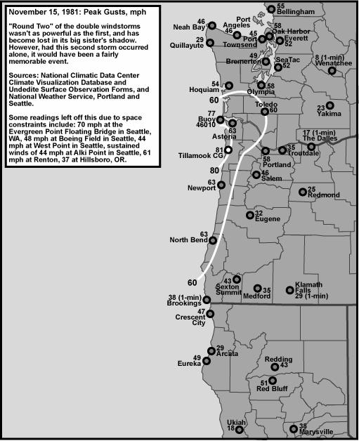
Mid-November 1981 had a particularly rare event: First, on November 13th and 14th (Fri and Sat), a major sub-960 mb cyclone developed, raced northward inside 130 W longitude, and delivered the strongest windstorm since the great Columbus Day storm of 1962 to the West Coast. A gale swept the San Francisco Bay Area, the Sacramento Valley, and northward, hitting typically sheltered places like Medford, then roaring across Oregon, Washington and into British Columbia. The 1981 storm had a broader reach than the 1962 event: high-wind criteria gusts extended east of the Cascade Mountains, as shown in Figure 1, above, with a gust to 59 mph at Yakima. Even Boise, Idaho, felt the fury of this storm, with its primary television broadcast antenna toppled by the wind. Peak winds west of the Cascades, though quite damaging, didn't reach Columbus Day levels at most locations. Second, right on the heels of the titanic "Friday-the-Thirteenth" storm, another strong cyclone, with at least a 983 mb center, developed and quickly shot into the Olympic peninsula on November 15th. This storm also carried strong gale inland. Though, for much of the Pacific Northwest, the wind speeds didn't reach the punishing levels of the storm's predecessor, as evidenced in Figure 2, below. The focus of this second storm was over a much smaller region, centered in Northwest Oregon and Southwest Washington. |
|
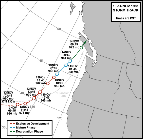
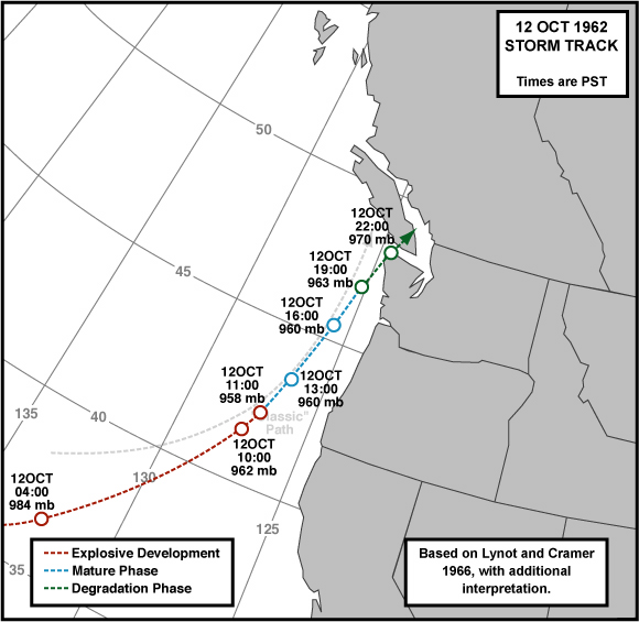
According to the National Climatic Data Center's Storm Data publication for November 1981, the two storms were responsible for at least 12 deaths in Oregon and Washington combined, tens of millions of dollars in damage to the two states, and power was terminated to hundreds of thousands of customers. Timber losses were high, but not as extensive as the Columbus Day storm--not even close, in fact. The Evergreen Point Floating Bridge (Hwy 520) suffered about $300,000 in damage as waves, swept by 75 mph wind gusts, slammed into the structure. According to insurance companies, the focus of damage occurred between Salem and Olympia and out to the coast. The Storm Data publication lists the minimum central pressure of the November 13-14, 1981 event at 956 mb (28.23") and the November 15th storm at 988 mb (29.18"). Other sources, including the National Weather Service, Portland, put the minimum pressure of the first storm at 958 mb (28.30"). For the November 15th storm, readings at buoy 46010 indicate a minimum pressure of at least 983.4 mb (29.04"); 983 mb is the value used on this website. This is a reminder that the exact central pressure of storms over the Pacific is hard to determine, and there can be considerable uncertainty in reported values. Figure 3, below, shows the track of the first, and deepest, cyclone. This storm essentially followed the "classic path," scraping the West Coast as it moved northward. Central pressure matched the depth of the great Columbus Day storm of 1962; however, the 1981 storm didn't track as close to shore as the 1962 catastrophe. The path of the Columbus Day storm is shown in Figure 4, below. The difference in track, among some other features of the 1981 storm, likely prevented the kind of wholesale destruction witnessed in '62. |
|
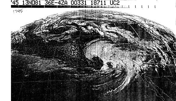
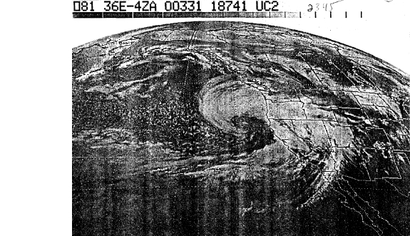
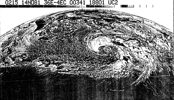
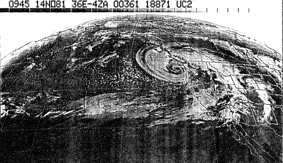
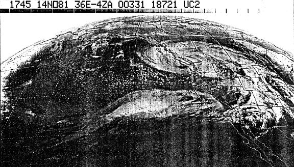
Storm Data Figures 5 through 9, below, are infrared satellite photos (Figure 7 is enhanced) of the November 13th-14th storm. These are scans of photocopies, which were kindly provided by Richard Halter (founder of the Oregon Tornado Chasers Society). The series tracks the development of the major windstorm from 11:45 PST on November 13th to 11:45 PST on November 14th. Note the November 15th storm developing right in the heels of the main event, quite visible in the last two images. The November 13-14 storm was quite organized, and developed the classic tightly wound spiral of sub-960 lows. |
|
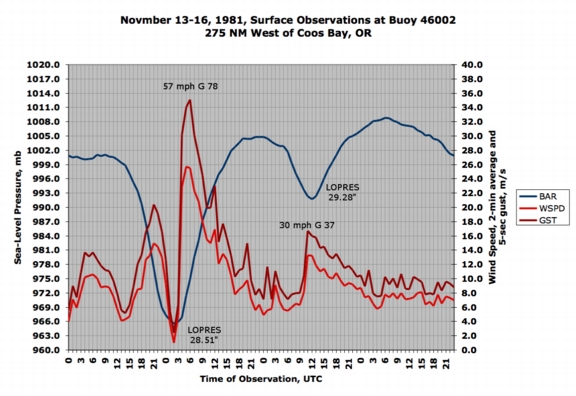
Figure 10, below, is a meteogram for Buoy 46002, located near 42.5 N and 130.4 W off the Southwest Oregon coast. Who said the Northwest doesn't get hurricanes? The low's center passed very close to this station, just to the east, and created a wind pattern that is reminiscent of the eye of a hurricane, with wind speed dropping dramatically. The low pressure near 965 mb would put this storm on the border between a category II and III hurricane on the Saffir-Simpson hurricane scale, if it were a true hurricane. A 5-second gust of 78 mph suggests the possibility of short ("instant" or 1-second) bursts in the range of 85 to 90 mph. The information in the graph is particularly important, for it constrains the cyclone's position for the time period 02:00 Z (18:00 PST), and informs that this storm tracked further to the west than the great Columbus Day storm. Figure 7, above, corresponds to the time period in question and allows the observer to see where the low center is in relation to the storm's spiral cloud structure. The November 15th storm skirted past station 46002 early in its development and didn't produce particularly strong winds. This situation changes dramatically for stations to the north, as will be shown below. |
|
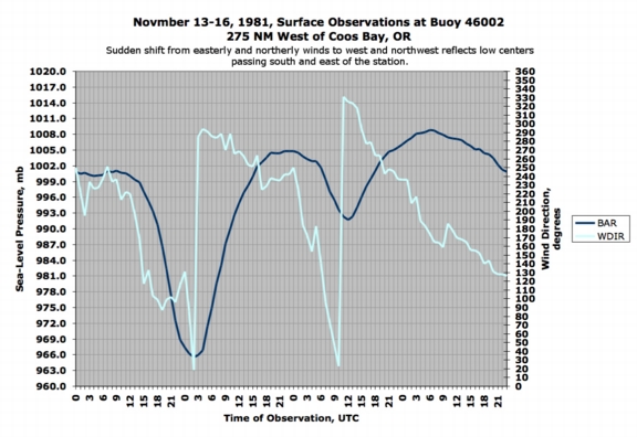
Figure 11, below, lets us know that the low centers of both storms did, indeed, track to the south and then east of the station 46002. Easterly winds shifting to near northerly put the low to the south of the station, then east. The dramatic shift to westerly marks the arrival of the bent-back occlusion, a region of the storm that can have a very strong pressure gradient and subsequently very potent winds. This feature has been called the "poisonous tail" of the midlatitude cyclone. The stinger is usually to the west and southwest of the low center. It struck station 46002 in full force on November 13th, with a sudden surge of wind into "storm force" category. |
|
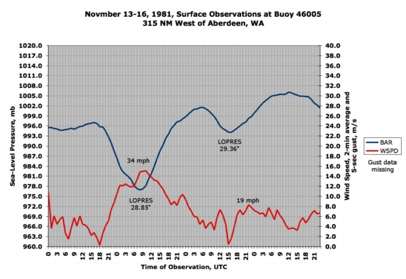
Figure 12, below, looks at the two storms' effects at buoy 46005 much further north, in this case, at about 46.1 N and 131.0 W, over 300 miles off of Aberdeen, Washington. Wind gust data is missing from this station, but wind speed shows the important detail. The November 14th low center tracked a distance east of the station that's similar to the distance that the Columbus Day storm would have tracked from station 46002 had the buoy been in place in 1962. The meteogram below shows approximately what would have happened at 46002 if the November 14th low had tracked as close to the coast as the Columbus Day storm. The result: less dramatic pressure swings and lower wind speeds. And, no dramatic drop in wind speed during pressure minimum. The November 14 cyclone's center was fairly far from station 46005. |
|
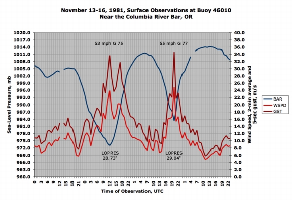
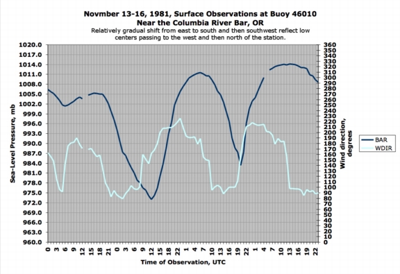
Figure 13, below, looks at the two storms' effects at a near-coast buoy, 46010, at the mouth of the Columbia River. Of note is the protracted period of gale-force winds (17.5 m/s is about 39 mph) during the first, deeper storm, and the sharp burst of wind during the second event, which actually resulted in faster speeds at this station. The second storm moved more quickly than the first. Also, notice the much deeper pressure trace for the 2nd storm when compared to the results from buoy 46002, in Figure 10 above. The November 15th storm had intensified considerably in the 8 hours between the pressure minima between the two stations. |
|
Figure 14, below, shows the wind direction progression at buoy 46010 during the two storms. In both cases, east winds gradually shift south and then southwest. Gradual is relative here--the shift from northerly to west and northwest at station 46002 happened within one observation period (1-hour), whereas the shifts below took more than one observation period in which to occur. These direction shifts are typical of coastal and inland stations during classic windstorm events, and are the mark of a cyclone center moving to the west and then north. |
|
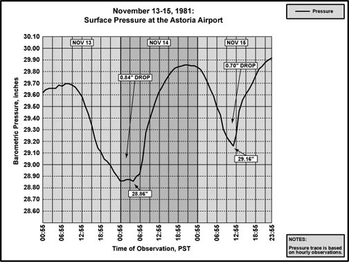
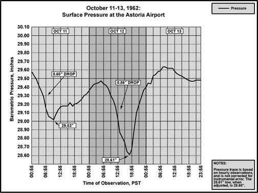
Figures 15 and 16, below, are two barograms for Astoria, one covering a 72-hour span for November 1981, and the other 72-hours for the Columbus Day Storm of October 1962. Note the much sharper, curve for the storm of 1962, a reflection of a system passing much closer to Astoria, and racing northward at a faster clip. Interestingly, the November 15th storm's trace isn't a far cry different from the Columbus Day Storm's trace (save for depth of fall). Tendencies were quite close between the two events, with a peak one-hour rise of 0.20" during the November 15, 1981 storm, and 0.23" during the storm of 1962. |
|
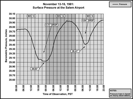
| Figure 17, below, is a barogram for Salem that covers a 72-hour span during the November 1981 storms. The first, larger event produced a broad U-trace similar to Astoria. The second event drew a trace much shallower and broader at Salem when compared to Astoria. The second low had a stronger northeasterly component to its motion than the first, and it made landfall on Washington's Olympic Peninsula. Ultimately, this path put the second low much closer to Astoria than Salem, and contributed to the strong differences in barometric tendencies. |
|
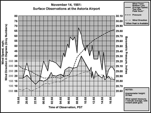
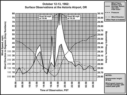
| Now to the meteograms. Figures 18 and 19, below, compare Astoria's wind and pressure conditions during the November 14, 1981 storm with the Columbus Day Storm. As with the 72-hour barograms, the faster swing in pressure for the 1962 storm is quite evident. The sudden, violent blast of wind during the 1962 Big Blow is also clear when compared to the more leisurely pace of the November 1981 storm. The energy of the Columbus Day Storm was concentrated in a narrower span of time, and the results were spectacular. The winds in 1981 lasted longer, but just didn't pack the punch of the 1962 event. |
|
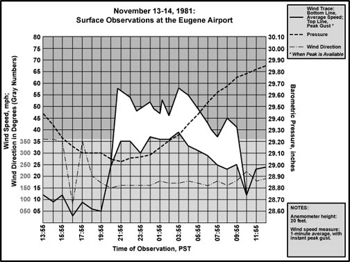
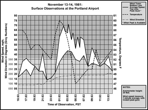
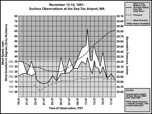
| Figures 20 through 22, below, track the November 14th storm's northward progress in the interior. The long period with gale-force wind gusts shows in all three, with the intensity at Sea-Tac somewhat reduced when compared to Portland. The November 14, 1981 cyclone began to weaken as it moved into Washington waters, and this probably spared the Seattle area somewhat--though a gust to 67 mph is fairly respectable. The Portland meteogram charts temperature instead of pressure, and provides a clear example of the temperature escalation typically seen during the onset of strong south winds during these storms. |
|
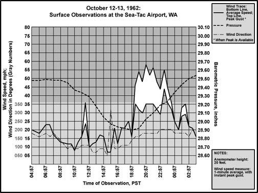
| This final meteogram, Figure 23, below, shows conditions at Sea-Tac Airport during the Columbus Day Storm for comparison with the November 14, 1981 chart above. Wind gusts were much lower during the Big Blow, one of many mysteries about the event. More discussion is below the meteogram... |
|
The two events, 1962 and 1981, behaved similarly at Sea-Tac, with wind direction changes and velocity escalations happening at similar positions along the prospective barometric traces. East winds gusted into the mid 30s as the pressure decreased, south winds arrived at the bottom of the pressure curves, with the highest winds achieved along the upswing. The Columbus Day Storm unfolded more rapidly, as evidenced by the sudden jump in average winds from 17 mph to 35 in a mere 30 minutes. It took a whopping six hours for the 1981 storm to accomplish a similar elevation in wind. The 1962 storm moved in so quickly that the entire barometric depression fits within the 24-hour chart. November 1981's barogram is a broad sweep that extends beyond 24 hours. To digress from the 1981 storm a moment, this contrast emphasizes one of the mysteries of the Columbus Day Storm at Sea-Tac: Energies were very concentrated during the 1962 event, yet there was no corresponding amplification in wind speed relative to other storms. Everything was in place for a major wind, as evidenced by peak gusts of 78 mph at Olympia, 85 at McCord Field near Tacoma, 81 at Paine Field in Everett. Yet the big winds generally skipped the Sea-Tac area. For what reasons? During Columbus Day 1962, the highest gusts at many stations, especially in Oregon, have been attributed to downdrafts along a highly unstable frontal boundary that coincided very closely with the time of minimum pressure, or more specifically, the time the storm was at its closest point to any given station. This is unusual, as frontal systems tend to run ahead of their parent lows in many windstorms, such as during the October 2, 1967. A frontal system arriving in phase with the storm's closest approach seems to have contributed to the Big Blow's punch. It seems that these downdrafts may have missed Sea-Tac in 1962. The Renton Airport, only a few miles east of Sea-Tac, had a peak gust to 100 mph in 1962, so it may have been a close call for SEA. However, the Renton Airport is located at the north end of the Kent Valley, along the south shore of Lake Washington, and its anemometer was at a height of 64 feet--all conditions favorable for high readings (I recall a March gale in 1986 that produced a peak gust of 43 mph at Sea-Tac, 59 at the Renton Airport, and 42 on my anemometer in the hills that brim the east side of the Kent Valley, for example). There is probably a more significant reason for the lower winds along the central Puget Sound. The front weakened as it moved into Washington--unlike Willamette Valley stations, there is no sharp pressure spike near the bottom of Sea-Tac's trace to mark the boundary's arrival. This probably contributed to the lower peak gusts at many Western Washington stations when compared to those in Northwest Oregon. In 1981, timing wasn't perfect either. A line of thunderstorms moved through the region as the cyclone moved northward into Vancouver Island, suggesting the possibility that they may have generated the higher peak gust at Sea-Tac when compared to 1962. The electrified squall arrived about 90 minutes after the airport's maximum wind velocity. Certainly, with the passage of the line, there was a corresponding elevation in winds (the second peak behind the main one in the meteogram), but the thunderstorms were clearly not responsible for the maximum velocity in 1981. In essence, the mystery of Sea-Tac's low wind speed in 1962, when compared to 1981, is still far from answered. There's enough of a disparity between the two storms, and readings around Sea-Tac Airport during the Columbus Day event, that suggests the possibility of equipment malfunction. |
General Storm Data Minimum Pressures and Maximum Gradients Table 1, below, is a list of the lowest barometric pressures, and time of occureence, from the two storms. As would be expected for cyclones moving northward offshore, the timing of the pressure lows generally occurred later for stations to the north. Exceptions appear in Washington, where Bellingham had its lowest reading an hour ahead of Sea-Tac. This is probably the result of the cyclone weakening as it moved offshore of Washington--as the storm's center had neared its closest point to Bellingham, it had weakened such that pressures had risen a few hundredths even though the storm was getting closer (in this case, close was about 100 miles off of Tatoosh Island). By 08:00 HRS, the time of Quillayute's lowest pressure, Bellingham's barometer had risen to 29.07". None of these minimums are lower than those produced by the Columbus Day Storm, the result of the 1981 low tracking further offshore than the 1962 tempest. Another indicator of this is the 28.85" 11-station average minimum pressure for the Columbus Day Storm, which is a full 0.15" lower than the November 14, 1981 storm's average minimum. The record-setting December 12, 1995 windstorm, which followed a similar track to the 1962 and 1981 storms, produced an 11-station average minimum that was 0.31" lower than the 1981 event! The 29.37" average minimum for the November 15, 1981 storm is in the range of many lesser windstorms. Source: Pressure minimums are microfilm copies of the unedited surface observation forms, obtained from the National Climatic Data Center. |
|
Table 2, below, is a list of the maximum pressure gradients, and time of occurrence, for the two storms. All these gradients were quite strong, but none achieved new records. The ACV-AST and OTH-UIL readings came within about 2.0 to 3.0 mb (0.06" to 0.09") of the all-time maximums produced by the December 12, 1995 windstorm (+33.9 mb / 1.00") and the October 21, 1934 event (+33.2 mb / 0.98") respectively. Source: microfilm copies of the unedited surface observation forms, obtained from the National Climatic Data Center. |
|
Table 2, notes: [1] Observations were not made from 23:00 to 05:00 each day at The Dalles, and the peak -13.0 mb gradient listed for AST-DLS occurred at 06:00, right at the beginning of observations--the actual maximum was probably higher during the observation "dead zone" before 06:00. |
Pressure Tendencies Table 3, below, lists the maximum hourly pressure falls and rises achieved during the November 13-14, 1981 storm for eleven Pacific Northwest stations. This storm had a strong effect on pressure tendencies throughout the region, the mark of a truly grand event. Source: microfilm copies of the unedited surface observation forms, obtained from the National Climatic Data Center. |
| ||||||||||||||||||||||||||||||||||||||||||||||||||||||||||||||||||||||||||||||||||||||||||
Table 3, notes: [1] Maximum hourly rise of +2.7 mb at Arcata is based on extrapolation from station pressure, for sea-level pressure data is missing from 16:50 to 20:59--the critical pressure climb phase for the storm at the site--due to apparent power outage. [2] The -3.7 mb maximum hourly fall for North Bend is the last of two occurrences, the other having occurred the hour before. [3] The -3.5 mb maximum hourly fall for Eugene is the last of two occurrences, the other having occurred the hour before. [4] The +4.1 mb maximum hourly climb for Salem is the last of two occurrences, the other having occurred the hour before. |
Table 4, below, lists the maximum hourly pressure falls and rises achieved during the November 15, 1981 storm for eleven Pacific Northwest stations. This storm produced some fairly quick pressure changes at stations such as North Bend, Astoria, and Olympia, but was no slouch overall. Like its day-earlier sister, a potent storm. Source: microfilm copies of the unedited surface observation forms, obtained from the National Climatic Data Center. |
| ||||||||||||||||||||||||||||||||||||||||||||||||||||||||||||||||||||||||||||||||||||||||||
Table 4, notes: [1] The +3.1 mb maximum hourly climb for North Bend is the last of two occurrences, the other having occurred at 09:00. [2] The -2.4 mb maximum hourly fall for Bellingham is the last of two occurrences, the other having occurred at 07:00. The +3.7 mb maximum hourly climb is the last of two occurrences, the other having occurred the hour before. |
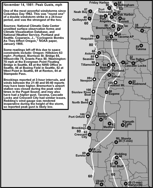
Peak Wind and Gust Table 5, below, lists the peak wind and gust from the first, and most powerful, storm, that struck on the 13th and 14th of November 1981. "Peak Wind" is a 1-minute average, and "Peak Gust" is an instant (approximately 1-second) average. By my own personal methodology, a wind event rates the term "windstorm" when the average peak gust of these eleven stations reaches 39.0 mph (gale force) or higher. The Inauguration Day storm ranked as a high-end moderate windstorm. Moderate windstorms have an average of 45.0 to 54.9, and major windstorms are those that reach or exceed 55.0. This ranking favors those storms that follow a northward path close to the U.S. Pacific Coast, and for good reason--such storms affect the largest land area, and therefore are potentially the most destructive. The November 13-14, 1981 windstorm followed just such a favorable path, and ranked far into the major category with an 11-station average peak gust of 65.9. The 1981 event is second only to the Columbus Day Storm of 1962, which had an 80.5 mph average peak gust. The average peak wind of 40.4 mph puts the November 13-14, 1981 windstorm in a rare category where maximum average winds across the stations reached into the gale force range. A value of 40.4 mph is all some storms can manage with peak instant gusts! North Bend had one of the most destructive winds in history with this storm. Noted gusts included: 61 mph at 21:23 on the 13th, 86 mph at 22:35, the storm maximum of 92 mph at 23:40, 81 mph at 00:22, 78 mph at 01:17, 71 mph at 02:02 and 66 mph at 03:22. Some of these gusts were significantly above the maximum burst of 81 mph during the Columbus Day Storm of 1962, and the damaging winds had a much longer duration during the 1981 storm. It is interesting that the peak wind and gust for the three Willamette Valley Stations happened at approximately the same time, right around 03:45 to 04:05. Both Salem and Portland reported lightning during the strong wind observations, and all three stations had light rain falling. Temperatures fell a few degrees after the ~04:00 observations. It appears that the maximum winds were associated with the passage of a fairly strong front that contained imbedded thunderstorms. The vertical mixing associated with such a boundary probably contributed to the powerful wind gusts, seen especially at Salem and Portland. Source: National Climatic Data Center, unedited surface observation forms. |
| Location | Peak |
Direction |
Obs Time of |
Peak |
Direction |
Obs Time of |
| California: | ||||||
| Arcata [1] | 29 |
220 |
20:09 HRS, 13th |
60 |
220 |
16:45 HRS, 13th |
| Oregon: | ||||||
| North Bend [2] | 58 |
200 |
00:37 HRS, 14th |
92 |
170 |
23:40 HRS, 13th |
| Astoria [3] | 40 |
230 |
09:55 HRS, 14th |
68 |
220 |
09:13 HRS, 14th |
| Medford | 40 |
190 |
20:55 HRS, 13th |
62 |
180 |
20:49 HRS, 13th |
| Eugene [4] | 39 |
170 |
03:52 HRS, 14th |
58 |
170 |
03:46 HRS, 14th |
| Salem [5] | 44 |
180 |
03:58 HRS, 14th |
71 |
170 |
04:06 HRS, 14th |
| Portland [6] | 44 |
180 |
03:53 HRS, 14th |
71 |
180 |
04:00 HRS, 14th |
| Washington: | ||||||
| Quillayute | 28 |
260 |
13:15 HRS, 14th |
48 |
230 |
13:13 HRS, 14th |
| Olympia [7] | 39 |
180 |
06:08 HRS, 14th |
64 |
180 |
03:26 HRS, 14th |
| Sea-Tac | 39 |
180 |
12:14 HRS, 14th |
67 |
180 |
12:11 HRS, 14th |
| Bellingham [8] | 44 |
170 |
11:55 HRS, 14th |
64 |
160 |
12:35 HRS, 14th |
| AVERAGE | 40.4 |
196 |
65.9 |
187 |
Table 5, notes: [1] Peak wind of 29 mph last of four occurrences. [2] Power failure from approximately 23:50 on the 13th to 00:53 on the 14th resulted in estimated wind direction readings. [3] Peak gust of 58 mph at Eugene was the last of two occurrences, the other having occurred at 21:43 on November 13th. [4] Power outage from 08:40 to 12:09 resulted in estimated wind direction during this time period, which includes the peak wind and gust noted in the table. [5] Peak wind of 44 mph at Salem was the last of two occurrences, the other having occurred in the hour before. [6] Power outage from 03:24 to 20:55 (with backup power finally working by 16:00) shut down the "multi-register wind speed indicator." Apparently redundant systems that didn't require outside power were available, as there is no indication of estimated wind readings. [7] Due to power outage from 03:24 to 14:35 at the Olympia station, wind direction and peak wind (note--not wind and gust) had to be estimated, this during the time of strong south winds. It's possible that the peak gust at Olympia was higher than the reported value. [8] Peak gust of 64 mph at Bellingham was the last of two occurrences, the other having occurred at 11:53 on November 14th. |
Table 6, below, lists the peak wind and gust from the second, less powerful storm, that struck on the 15th of November 1981. The numbers reveal a storm that was decently in the moderate category, with an 11-station average peak gust of 46.7. Had this storm not occurred one day after one of the strongest events since 1950, it probably would have been more significant, especially across much of Western Washington. The first storm certainly removed many trees and limbs that were waiting to fall--the second cyclone was left with the "dregs," and some weakened material from the first. Source: National Climatic Data Center, unedited surface observation forms. |
| Location | Peak |
Direction |
Obs Time of |
Peak |
Direction |
Obs Time of |
| California: | ||||||
| Arcata | 25 |
240 |
09:50 HRS, 15th |
29 |
150 |
03:50 HRS, 15th |
| Oregon: | ||||||
| North Bend | 29 |
220 |
10:55 HRS, 15th |
63 |
180 |
08:02 HRS, 15th |
| Astoria | 41 |
170 |
12:55 HRS, 15th |
63 |
170 |
13:08 HRS, 15th |
| Medford | 16 |
120 |
08:59 HRS, 15th |
35 |
120 |
08:46 HRS, 15th |
| Eugene | 22 |
210 |
13:55 HRS, 15th |
28 |
170 |
13:05 HRS, 15th |
| Salem | 30 |
190 |
11:58 HRS, 15th |
44 |
190 |
11:43 HRS, 15th |
| Portland | 35 |
190 |
13:11 HRS, 15th |
58 |
190 |
13:07 HRS, 15th |
| Washington: | ||||||
| Quillayute | 14 |
220 |
20:23 HRS, 15th |
29 |
210 |
19:49 HRS, 15th |
| Olympia [1] | 32 |
180 |
14:53 HRS, 15th |
58 |
180 |
14:25 HRS, 15th |
| Sea-Tac | 30 |
190 |
14:49 HRS, 15th |
52 |
190 |
15:23 HRS, 15th |
| Bellingham | 31 |
180 |
17:50 HRS, 15th |
55 |
170 |
17:01 HRS, 15th |
| AVERAGE | 27.7 |
192 |
46.7 |
175 |
Table 6, notes: [1] Due to power outage starting at 14:34, and continuing through the rest of the day, at the Olympia station, wind direction and peak wind (note--not wind and gust) had to be estimated, this during the brief time of strong south winds for the November 15th storm. It's possible that the peak gust at Olympia was higher than the reported value. In fact, a note on Olympia's surface observation form MF1-10B states: "Pk wind doubtful Col. 71. Could be higher." With a gust of 58 mph observed, this event was quite strong at Olympia. |
Table 7, below, compares the peak gusts of the November 14, 1981 windstorm to those of the legendary Columbus Day "Big Blow" of 1962, with differences in wind force listed. A positive number in the "Difference, mph" column below reflects a higher peak in the Nov 1981 windstorm, and negative reflects a stronger peak in the Columbus Day Storm. Data source: National Climatic Data Center, unedited surface observation forms. |
|
Unlike comparing the 1962 Big Blow with storms in the modern (post-1993) era, the methods of recording wind speed were similar between the 1962 and 1981 storms, offering a fairly straightforward comparison. The possibility of observer error exists in the storm data, and some recording problems were found in the 1981 surface observation forms. It seems that in the surface records for Sea-Tac, the peak gust was being reported as fastest mile--which is a significant error that's repeated at Sea-Tac for other storms in the early 1980s. This mistake also turned up at other stations in earlier storms, such as at Salem for the October 2, 1967 event. The fastest 1-minute and peak gust figures for Sea-Tac listed in the table were taken from the hourly observations, not the apparently erroneous daily summary. This was not the only mistake found in the surface observation forms for the November 14, 1981 windstorm. The sea level pressure readings for Olympia were in fairly serious error for the hours of 09:00-11:00--so much so that a barogram had to be consulted to obtain the values during the critical stage of the storm. Problems also occurred with Olympia's wind record in 1981. The power failed near the beginning of the gale, at 03:24 LST, and knocked out instrumental readings for wind velocity and direction. Wind data after that time up to 14:35 are estimated values. Olympia's tale of woe doesn't end here. The sling psychrometer was smashed at the height of the storm (perhaps the buffeting gale distracted the observer), and wasn't replaced until about two hours later. Astoria also suffered a blackout, which forced the estimation of wind readings for the 08:56 to 11:57 observation period. And at the Portland station, which during the Columbus Day Storm of 1962 had lost power to the gauges with the unfortunate loss of wind readings at the critical height of the storm, had the same thing happen again in 1981--at the exact moment that Olympia's current stopped! Portland's "multi-register wind speed indicator" was rendered inoperative. Emergency power, for some reason, wasn't running until eleven hours later. Fortunately, a backup anemometer of some kind was available, and wind readings weren't of the estimated variety. There are other potential sources of error that may not be so obvious. To quote from the March 1998 edition of the ASOS User's Guide:
Before the controlled automation of ASOS, comparing wind velocities for the same station without consulting the initials of who did the observing was an invitation for extra error. And, indeed, the exact methodology employed by one observer could have changed with time, or differed with other external factors such as stress, tiredness and illness. With 19 years between the two storms, it is highly unlikely that the same people were doing the observing, further adding to the possible source of error. A quick check of the Sea-Tac and Portland surface observation forms for October 12, 1962 and November 14, 1981 show that different people were on duty during the separate storms. Sometimes, as shifts changed, more than one person monitored events during a single storm. These people were trained weather observers, and this certainly reduced potential error, but most likely didn't eliminate it. Even with possible human-related inconsistencies, the wind data seems to put the Columbus Day Storm on top, as the readings produced by the Big Blow are significantly higher at many locations--save for some select places. Like with so many windstorms, it was again demonstrated on November 14, 1981 that regional difference can be significant, and one location might receive a marginal gale while another is pummeled with hurricane gusts. This even with a windstorm that produced a remarkable uniformity of peak winds among many stations (65-75 mph). The 1981 peak gust for North Bend is an example. The 92 mph reading is one of the highest winds on record for that station, and significantly exceeds the 81 mph peak for the Columbus Day Storm, and the 86 mph gust during the more recent Big Blast of December 1995. Wind velocities in the Willamette Valley for the 1981 storm are much lower than the 1962 Terrible Tempest of the Twelfth. |
Last Modified: July 9, 2004 You can reach Wolf via e-mail by clicking here. | Back | |